[Rooftop view of downtown Vancouver at night]
- AM1376-F44-: 2019-051.19
- Item
- [197-]
64 results with digital objects Show results with digital objects
[Rooftop view of downtown Vancouver at night]
[View from downtown looking southeast]
Item is a photograph taken from [Harbour Centre?] showing a view of downtown and the east end of False Creek around Main and Terminal Avenue. Photograph includes the Georgia Viaduct and in the foreground are buildings along Hastings, Pender, Cambie, Beatty Streets including the Sun Tower, Woodward's, the Dominion Building and part of Victory Square.
Item is a photograph taken from Harbour Centre [?] showing the downtown from Dunsmuir and Homer Streets, including the Beatty Street Drill Hall and former Canada Post office, the Georgia Viaduct and the north side of the False Creek in the foreground. The Cambie Street Bridge is centre, and the south shore of False Creek and City Hall and other buildings are visible in the background.
View from downtown looking east
Item is a photograph taken from Harbour Centre [?] looking east at Water Street and East Cordova Street, following the waterfront up to around Dunlevy Avenue. Buildings visible include the Hotel Europe marking the intersection of Carrall and Alexander Streets, former Public Safety Building, and St. James Anglican Church.
Item is a photograph taken from Harbour Centre [?] showing the north side of the False Creek in the foreground.
Item is a photograph taken from Harbour Centre [?] showing the downtown from Dunsmuir and Homer Streets, including the Beatty Street Drill Hall and former Canada Post office, the Georgia Viaduct and the north side of the False Creek in the foreground. The Cambie Street Bridge is centre, and the south shore of False Creek and City Hall and other buildings are visible in the background.
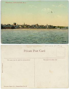
Aerial of Vancouver, B.C. [over False Creek]
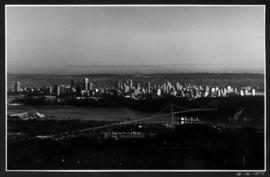
Item is a photograph showing the Burrard Street Bridge, former train trestle and the West End neighbourhood as well as other parts of downtown.
Aerial shot from over Stanley Park
Item is a photograph showing Coal Harbour (left) and English Bay (right) and downtown buildings centre.
Summer 1982 - Aerial shot from the south side of False Creek before Expo
Item is a photograph showing housing complexes along the south shore of False Creek and on the north side construction has begun for the Expo 86 site and BC Place Stadium is under construction, past the Cambie Bridge on the right.
Item is a photograph showing downtown Vancouver from English Bay with Beach Avenue and Jervis Street and the former Tudor Manor apartment building visible.
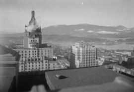
T. Eaton Co. : panorama shots of city and skyline from top of old Hotel Vancouver

T. Eaton Co. : panorama shots of city and skyline from top of old Hotel Vancouver

T. Eaton Co. : panorama shots of city and skyline from top of old Hotel Vancouver
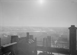
T. Eaton Co. : panorama shots of city and skyline from top of old Hotel Vancouver
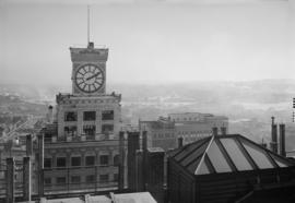
T. Eaton Co. : panorama shots of city and skyline from top of old Hotel Vancouver

T. Eaton Co. : panorama shots of city and skyline from top of old Hotel Vancouver

T. Eaton Co. : panorama shots of city and skyline from top of old Hotel Vancouver
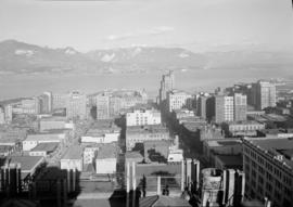
T. Eaton Co. : panorama shots of city and skyline from top of old Hotel Vancouver

T. Eaton Co. : panorama shots of city and skyline from top of old Hotel Vancouver

Immigration Building - flower display - Harbour Tower scenery - night view of Vancouver
Part of Harry Lin Chin fonds
Item is a film narrated by Harry Lin Chin in both Chinese and English. Film contains footage showing the demolition of the Immigration Building, magnolia trees, Vancouver Museum and parking lot, Vanier Park, Burrard Street Bridge, views of North Shore and West End from Vanier Park, views of North Shore, Burrard Inlet, Chinatown, and downtown Vancouver from the revolving Harbour Tower restaurant, and scenes aboard the sea bus.
![1) Howe Sound Cruise 2) [Grand Coulee Dam Construction] - SF/Golden Gate 3) Van Streets Pre-Royal...](/uploads/r/null/c/3/c/c3c817e4e62691cabc1e0625451afdcf9bc92e39d7d64d6603dfa99bf84ea84a/b8ba05ff-8100-4e8f-84ac-0b3b240b61ae-2013-062_142.jpg)
Part of City of Vancouver Archives sound recording and moving image collection
Item is a film containing footage of the Howe Sound cruise ship leaving the Burrard Inlet harbour in downtown Vancouver, the Marine Building, Hotel Vancouver, a cruise ship passing by Lighthouse Park and docking in Howe Sound, Britannia Beach, the Britannia Mine, the Grand Coulee Dam construction and land excavation. Film also shows a sequence at a zoo with tigers and bears, a car driving across the Golden Gate Bridge, Vancouver street scenes with flags and banners in preparation for the royal visit, City Hall and views looking north from the Burrard Bridge at downtown Vancouver.

Vancouver, B.C., Canada : the English Bay skyline at night
Item is a postcard printed with an image of the English Bay skyline at night. Caption on back of postcard: "The English Bay skyline at night is an impressive sight as the multi colored lights reflect on the waters. The row of chairlift lights on Grouse Mountain are visible for miles on clear evenings."

View from roof garden, Hotel Vancouver
Part of Bertram Emery fonds

Top of Taylor Way - clearing for BP and Capilano Golf Course
Part of City of Vancouver Archives sound recording and moving image collection
Item is a film containing footage of the clearing and construction of British Properties and the Capilano Golf Course. The film also shows views of downtown Vancouver from the harbour and street views of downtown Vancouver.

N.Y., clearing Br. Properties and Capilano, shots around Vancouver
Part of City of Vancouver Archives sound recording and moving image collection
Item is a film containing home movie footage showing New York from a boat, fishing, children and family playing outdoors, mountains, views of downtown Vancouver from a boat and from above, an outdoor meal and clearing of the British Properties.

Part of Yaletown Productions Inc. fonds
This item consists of raw footage featuring B.C./Expo 86 aerials; shot in 35mm and transferred to one inch tape. Original negative no longer exists and only video footage survives. Some of this material was used in Yaletown Production's video postcard series. Includes nighttime footage of downtown Vancouver.
![Conference Hangar #3 doctors [12 of 32]](/uploads/r/null/f/3/f/f3f42dd8dfc9375daeafa65b06c8a9abe09bd59ba7588ab49ca3c431dd16a8ec/97c63cca-8a69-43ef-8d24-633a04ecf233-2011-130_142.jpg)
Conference Hangar #3 doctors [12 of 32]
Part of Habitat Forum photographs
Item is a photograph showing a view of downtown from the water.
![[View of] Downtown [Vancouver]](/uploads/r/null/d/2/c/d2c29f12b233a4c625b60e7ef1d46ee345f17c667d309d7ec9dc4409f344d198/8a99be21-2605-4b2f-93e7-f2c8706741ae-CVA293-075_142.jpg)
[View of] Downtown [Vancouver]
![[View of] Downtown [Vancouver]](/uploads/r/null/c/c/1/cc1de3393ac8f53278fc39aa085184d551318f8323cf61908b3092b569add053/0f3b47ab-21e5-4647-a4a5-b1a9df00ad66-CVA293-075_142.jpg)
[View of] Downtown [Vancouver]

Downtown buildings at night from Hallelujah Point

Downtown buildings at night from Hallelujah Point
![[Downtown buildings at night] from Hallelujah Point](/uploads/r/null/3/c/7/3c7720e60b0972d26fdc2539afea5c9c49e27f085295d8d8f8600ab64f00c366/33acfefe-c307-490c-9031-cbc998039f83-CVA293-025_142.jpg)
[Downtown buildings at night] from Hallelujah Point
![[Downtown buildings at night] from Hallelujah Point](/uploads/r/null/a/5/6/a5671e90548f3d81dee3269383829a7559227501f3e12753a6a028a2bc2d6733/47a986b9-7978-4f1c-90da-dc6f3a85037a-CVA293-025_142.jpg)
[Downtown buildings at night] from Hallelujah Point
![[View of West End and downtown Vancouver] from Spanish Banks](/uploads/r/null/a/0/c/a0ce93b95f18ded5e0f176207bfb577d71c51392df94f5ce8c813377f3034dae/007d7e98-e91d-4f0c-98e5-dac656083dd8-CVA293-010_142.jpg)
[View of West End and downtown Vancouver] from Spanish Banks
![[View of West End and downtown Vancouver] from Spanish Banks](/uploads/r/null/8/3/c/83c17ad4f8b09fa6d9a6eda8bedaf78994ad0eac446e7f38e8bf4c3599ac68e9/85ece1d8-570d-4727-9996-27438585ad1c-CVA293-010_142.jpg)
[View of West End and downtown Vancouver] from Spanish Banks
![[View of West End and downtown Vancouver] from Jericho Beach](/uploads/r/null/c/a/5/ca5163e9892bf6259ec84d90b8e3e898653f45baa2a7ec8cc19024521e671b08/9f8fd423-f1b0-47df-97a7-ff91438a7b7a-CVA293-009_142.jpg)
[View of West End and downtown Vancouver] from Jericho Beach
![[View of West End and downtown Vancouver] from Jericho Beach](/uploads/r/null/d/3/3/d33c3994292fc6045d8f4be61d6da457dc7a1f6f33a92e9d3a980312369122a5/32a9ac85-4277-4eca-8424-fa17c600a662-CVA293-009_142.jpg)
[View of West End and downtown Vancouver] from Jericho Beach
![Fairyland, B.C. [View of the West End and downtown Vancouver taken at night from Jericho Beach.]](/uploads/r/null/d/f/a/dfac1737c680e690f5df79ec74560374b99585d3e61e6432c9ee22069f7f6da3/399457d4-0f6d-4823-929a-1cde999e64c6-CVA293-008_142.jpg)
Fairyland, B.C. [View of the West End and downtown Vancouver taken at night from Jericho Beach.]
![Fairyland, B.C. [View of the West End and downtown Vancouver taken at night from Jericho Beach.]](/uploads/r/null/a/8/e/a8e3a495f59bcd444d67c1f58f4e6637f2b485e6b359321dfad9189cbbe72abe/4aa2b5c6-07eb-41a9-8034-9911274f8595-CVA293-008_142.jpg)
Fairyland, B.C. [View of the West End and downtown Vancouver taken at night from Jericho Beach.]
View of Lions Gate Bridge, downtown and West End from West Vancouver

View of Lions Gate Bridge, downtown and West End from West Vancouver

Aerial view of Burrard Street and surrounding area
Part of City of Vancouver fonds
![Aerial of Vancouver [looking across False Creek to downtown]](/uploads/r/null/4/a/f/4afc9e796fba938d8c20f811a6931cd1465924c5f88c79fe4b20a0917bc57573/54f347ac-0258-4ebf-9162-a8b64c1f6af9-CVA306-16_142.jpg)
Aerial of Vancouver [looking across False Creek to downtown]
Part of Greater Vancouver Visitors and Convention Bureau fonds

Part of Greater Vancouver Visitors and Convention Bureau fonds

Part of George Thompson fonds
![Vancouver, B.C. [View of downtown (Ailsa Lodge), Coal Harbour and Stanley Park]](/uploads/r/null/6/3/9/639be563fcca94701436caa27c2e67f7d7fea5ac6d8bd3edd5806930da05dddc/d0bd6cfd-b64c-4d4e-a785-4716ad3db5af-CVA298-004_142.jpg)
Vancouver, B.C. [View of downtown (Ailsa Lodge), Coal Harbour and Stanley Park]
Part of George Thompson fonds
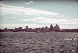
View of downtown from Burrard Inlet
Part of Leopold Bentley family fonds

View of Canada Place and Downtown Vancouver
Part of City of Vancouver fonds