
- COV-S20-: CVA 433-1
- Item
- [ca. 1947]
Part of City of Vancouver fonds
Part of City of Vancouver fonds

Part of City of Vancouver fonds

Part of City of Vancouver fonds

Part of City of Vancouver fonds
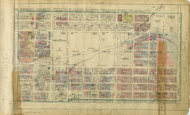
![General plan - sheet 11 [Arbutus Street to Celtic Avenue to Fraser River]](/uploads/r/null/3/f/d/3fd9a37e7d563f1ab5ea2d9d72418a55895d86310b0a78eab48407b8b835b701/136e3b9b-509e-4f21-94e7-d53135afd227-LEG1153_142.jpg)
General plan - sheet 11 [Arbutus Street to Celtic Avenue to Fraser River]
Part of City of Vancouver fonds

Part of City of Vancouver fonds

Part of City of Vancouver fonds

Part of City of Vancouver fonds

Part of City of Vancouver fonds


Part of City of Vancouver fonds

Part of City of Vancouver fonds

![Zoning [and sectional plan of Vancouver] : supplementary information for sheet 1](/uploads/r/null/1/5/d/15df26b8db6e8b8e67bda7138640fbae6cb21d51022fd1ab76864f56dc74af56/471c151f-eeca-4878-9a4b-e412f7f36b5e-LEG1319_142.jpg)
Zoning [and sectional plan of Vancouver] : supplementary information for sheet 1
Part of City of Vancouver fonds
Item contains annotations relating to zoning by-laws depicted on sheet 1 of sectional map.
![Zoning [and sectional plan of Vancouver] : [Boundary Road to Burrard Inlet to Slocan Street to Tr...](/uploads/r/null/3/f/b/3fb71b15f36af671916516be0d1960b01cda0c8d93ea0e65d6d12fa3800f1b34/0cc6de25-668e-4d35-a558-59c07ae76905-LEG1319_142.jpg)
Part of City of Vancouver fonds
![Zoning [and sectional plan of Vancouver] : [Boundary Road to Triumph Street to Slocan Street to C...](/uploads/r/null/6/1/1/611306d71d5389b090e2a6db2f164506db822fab5adc56e43bceb5d810d550e6/235e2070-7e08-4bd6-9fa6-e9a268eeb925-LEG1319_142.jpg)
Part of City of Vancouver fonds
![Zoning [and sectional plan of Vancouver] : [Slocan Street to Eighteenth Avenue to Knight Street t...](/uploads/r/null/c/3/7/c370aa4081a5e8439e0ff91f67426cd3dbff113f196299063d997fed8e4f975f/2aa98b14-2348-45b8-8d98-ffe2d1792e49-LEG1319_142.jpg)
Part of City of Vancouver fonds
![Zoning [and sectional plan of Vancouver] : supplementary information for sheet 7](/uploads/r/null/c/5/d/c5d1ce97048cd576e241c40ba7cafd4121efe3f81e2d64115faf75ea3ba6a71b/e2e127d0-af55-4c88-be07-1fcf4e27f94f-LEG1319_142.jpg)
Zoning [and sectional plan of Vancouver] : supplementary information for sheet 7
Part of City of Vancouver fonds
Item contains annotations relating to zoning by-laws depicted on sheet 7 of sectional map.
![Zoning [and sectional plan of Vancouver] : supplementary information for sheet 8](/uploads/r/null/2/1/9/21994b4d1731b88a93eab05595cbb4c6feaa9244d95410764154a17ca77176ec/4415afed-c3e6-4543-84fc-99971dc76f97-LEG1319_142.jpg)
Zoning [and sectional plan of Vancouver] : supplementary information for sheet 8
Part of City of Vancouver fonds
Item contains annotations relating to zoning by-laws depicted on sheet 8 of sectional map.
![Zoning [and sectional plan of Vancouver] : [Clark Drive to Burrard Inlet to Carrall Street to Kee...](/uploads/r/null/0/7/3/07343150b80da66a67dc09ec8f384ea40250f04a90135f49d168a251d4e4a629/2ad806b1-231b-47bc-ba5e-971d90b28287-LEG1319_142.jpg)
Part of City of Vancouver fonds
![Zoning [and sectional plan of Vancouver] : supplementary information for sheet 13](/uploads/r/null/8/1/5/8159acedc9381f501a3828674f6454d7c8f52c04b6864743b8c525638e5252a2/08785813-5a5b-47ac-a0b3-bab25c589cb2-LEG1319_142.jpg)
Zoning [and sectional plan of Vancouver] : supplementary information for sheet 13
Part of City of Vancouver fonds
Item contains annotations relating to zoning by-laws depicted on sheet 13 of sectional map.
![Zoning [and sectional plan of Vancouver] : supplementary information for sheet 14](/uploads/r/null/5/2/c/52cfd574e3f7c211b6e91a88937c14cc0a831e5e7461c7fb206f374041137720/53de5983-114f-4d08-a4e6-86bbd08e7d6c-LEG1319_142.jpg)
Zoning [and sectional plan of Vancouver] : supplementary information for sheet 14
Part of City of Vancouver fonds
Item contains annotations relating to zoning by-laws depicted on sheet 14 of sectional map.
![Zoning [and sectional plan of Vancouver] : supplementary information for sheet 15](/uploads/r/null/0/2/8/0284fa4f53fd690adc878ed7b0e00e6b164ce209e81e4242b02d718f7b0dff90/05e042bf-7a8c-499e-8f9c-b6914257f21f-LEG1319_142.jpg)
Zoning [and sectional plan of Vancouver] : supplementary information for sheet 15
Part of City of Vancouver fonds
Item contains annotations relating to zoning by-laws depicted on sheet 15 of sectional map.
![Zoning [and sectional plan of Vancouver] : [Oak Street to Fourth Avenue to Maple Street to Sixtee...](/uploads/r/null/d/8/3/d83c503d6c6b2b5f31c09989a2de72abd18ec92c458b10211a2a2eaad488e478/fac24afc-05ae-4115-bcf5-1dd4c02c434b-LEG1319_142.jpg)
Part of City of Vancouver fonds
![Zoning [and sectional plan of Vancouver] : [Trafalgar Street to Sixteenth Avenue to Wallace Stree...](/uploads/r/null/6/d/e/6dea1a52ef90573edd751280e053d4bb2e6efbeac6251e0539c425f185942bb2/aef1e547-299c-45ca-adf4-cb54fc664cb6-LEG1319_142.jpg)
Part of City of Vancouver fonds
![Zoning [and sectional plan of Vancouver] : [Cambie Street to Fifteenth Avenue to Granville Street...](/uploads/r/null/c/e/8/ce89e627ac11a5d1595a6c5a5a4d6db1f0e33553a61efb18ab23add4aabd6a4e/9e9c4b5e-4f8a-47ac-9e39-646ae2d2816b-LEG1319_142.jpg)
Part of City of Vancouver fonds
![Zoning [and sectional plan of Vancouver] : [Wallace Street to Twenty-ninth Avenue to the Universi...](/uploads/r/null/4/6/1/46142fbbcb2eb5915bdb38c2a8f829ff05452ad54ad196115900fd739bf9f852/ff233104-5fda-49f3-9e62-79b70104a194-LEG1319_142.jpg)
Part of City of Vancouver fonds
![Zoning [and sectional plan of Vancouver] : [Macdonald Street to Forty-ninth Avenue to Wallace Str...](/uploads/r/null/9/b/e/9be793b7dee726af3512f1e5c54f8fb9336563e8f67b72993d5ee8f1edbf148e/0e4a2fb8-ad2e-469c-a9a2-dbccd8d99418-LEG1319_142.jpg)
Part of City of Vancouver fonds
![Zoning [and sectional plan of Vancouver] : supplementary information for sheet X](/uploads/r/null/d/a/9/da971cdec9733f9cd02db256192709035525a3d1dcbf7345138db784eefedd4e/00589e53-3b43-4bb1-983d-533a60521184-LEG1319_142.jpg)
Zoning [and sectional plan of Vancouver] : supplementary information for sheet X
Part of City of Vancouver fonds
Item contains annotations relating to zoning by-laws depicted on sheet X of sectional map.
![Zoning [and sectional plan of Vancouver] : [Ash Street to Fifty-ninth Avenue to Cornish Street to...](/uploads/r/null/4/7/d/47dffc9b481f5b2587fab7e715a81624e47ed6e22a0f8924748e7f4863ed335f/039085c5-3dd0-4789-9c76-5ab1038157a7-LEG1319_142.jpg)
Part of City of Vancouver fonds
![Zoning [and sectional plan of Vancouver] : supplementary information for sheet Z](/uploads/r/null/1/b/7/1b731c46965252a73a05ea6ae6fde5d7bee3edd2ce6918f3145fd196fdb192c0/2108bc3f-ca24-4cd7-abaf-98d4d01a8296-LEG1319_142.jpg)
Zoning [and sectional plan of Vancouver] : supplementary information for sheet Z
Part of City of Vancouver fonds
Item contains annotations relating to zoning by-laws depicted on sheets V and Z of sectional map.
![Zoning [and sectional plan of Vancouver] : supplementary information for South Vancouver section ...](/uploads/r/null/f/c/c/fccaf1995bf5af8f2255b8b674742f568490c9345cb33aa45e01975dd57dc485/605b2c7d-cd66-4d7f-97e3-271b1fda7f72-LEG1319_142.jpg)
Part of City of Vancouver fonds
Item contains annotations relating to zoning by-laws depicted on sheet 1 of South Vancouver sectional map.
![Zoning [and sectional plan of Vancouver] : [Bruce Street to King Edward Avenue to Prince Edward S...](/uploads/r/null/d/d/2/dd2ed325848d3ac32bd219882aa73a93579dc4d8fe65cdfffe816830ebed3973/7edc1ef3-4043-4ccb-8e4c-32773cdd9ffc-LEG1319_142.jpg)
Part of City of Vancouver fonds
![Zoning [and sectional plan of Vancouver] : supplementary information for South Vancouver section ...](/uploads/r/null/2/6/0/2608d0d63481e3c8978db3be443e9b66d7234ec083a47d75000e1ef86da9ef76/4965a245-9306-4c79-b75e-0a261b934ce2-LEG1319_142.jpg)
Part of City of Vancouver fonds
Item contains annotations relating to zoning by-laws depicted on sheet 5 of South Vancouver sectional map.
![Zoning [and sectional plan of Vancouver] : [Bruce Street to Thirty-fifth Avenue to Prince Edward ...](/uploads/r/null/3/d/a/3daa9b206617226e50b095cc8603fdae767b3fc414c195916f05b66e295fdead/4a609b32-6f5b-429b-a5bb-9b2ecef4c865-LEG1319_142.jpg)
Part of City of Vancouver fonds
![Zoning [and sectional plan of Vancouver] : [St. George Street to Forty-seventh Avenue to Cambie S...](/uploads/r/null/3/9/4/3941a4fe4a112dc53ad93bb5a5ef103cf034b473debbf376f05d2c3d456dabdb/1db7e5aa-a53b-4bbc-9651-21067e7a026b-LEG1319_142.jpg)
Part of City of Vancouver fonds
![Zoning [and sectional plan of Vancouver] : [St. George Street to Fifty-eighth Avenue to Ash Stree...](/uploads/r/null/f/d/0/fd040366ef532467eded717fb492810507a7765ff1aebea743bdea53ff5c99b5/9e11c01b-096c-4c73-9e56-7dd0ece8a85f-LEG1319_142.jpg)
Part of City of Vancouver fonds
![Zoning [and sectional plan of Vancouver] : [Boundary Road to Fiftieth Avenue to Raleigh Street to...](/uploads/r/null/6/5/b/65bbd9f1763982aae0e8cc3f391040ca152c3d54f827b433660452db2f46cca2/70572df7-147c-4c2f-bdca-d1a4411454cf-LEG1319_142.jpg)
Part of City of Vancouver fonds
Item is a map showing the area located north of sheet 18.
![Zoning [and sectional plan of Vancouver] : [Boundary Road to Sixty-fifth Avenue to Vivian Street ...](/uploads/r/null/1/e/3/1e30fdaa9b73eb9bd49b193a7ebb4665b5ba524b0f8f82e32afcdfb2190b2d1b/64a6753d-caf0-4726-8c27-21e998252b68-LEG1319_142.jpg)
Part of City of Vancouver fonds

Vancouver section 2 supplementary information
Part of City of Vancouver fonds
Part is a sheet showing information noted about assessments and other information relevant to Vancouver section 2.

Part of City of Vancouver fonds
Part is a section depicting the area bounded by Boundary Road to Triumph Street to Slocan Street to Charles Street. The sheet has been extensively annotated, with colour coded areas to depict land use, status of lots as tax sale properties for sale, sewer and water lines, as well as other colour codes that are not noted on the legend at the front of the volume.
Part of City of Vancouver fonds
Part is a section depicting the area bounded by Boundary Road to Seventh Avenue to Slocan Street to Seventeenth Avenue.

Vancouver section 7 supplementary information
Part of City of Vancouver fonds
Part is a sheet showing information noted about assessments and other information relevant to Vancouver section 7.

Vancouver section 10 supplementary information
Part of City of Vancouver fonds
Part is a sheet showing information noted about assessments and other information relevant to Vancouver section 10.

Vancouver section 11 supplementary information
Part of City of Vancouver fonds
Part is a sheet showing information noted about assessments and other information relevant to Vancouver section 11.

Part of City of Vancouver fonds
Part is a section depicting the area bounded by Clark Drive to Burrard Inlet to Carrall Street to Keefer Street. The sheet has been extensively annotated, with colour coded areas to depict land use, status of lots as tax sale properties for sale, sewer and water lines, as well as other colour codes that are not noted on the legend at the front of the volume.

Vancouver section 13 supplementary information
Part of City of Vancouver fonds
Part is a sheet showing information noted about assessments and other information relevant to Vancouver section 13.

Part of City of Vancouver fonds
Part is a section depicting the area bounded by Oak Street to Fourth Avenue to Maple Street to Sixteenth Avenue. The sheet has been extensively annotated, with colour coded areas to depict land use, status of lots as tax sale properties for sale, sewer and water lines, as well as other colour codes that are not noted on the legend at the front of the volume.

Vancouver section 17 supplementary information
Part of City of Vancouver fonds
Part is a sheet showing information noted about assessments and other information relevant to Vancouver section 17.

Vancouver section 19 supplementary information
Part of City of Vancouver fonds
Part is a sheet showing information noted about assessments and colour coding relevant to Vancouver section 19.