
- AM1533-S2-4-: 2009-005.508
- Item
- Oct. 2002
Part of Dunbar History Project fonds
Item filed under Transportation. Courtesy of Angus McIntyre.
16 results with digital objects Show results with digital objects
Part of Dunbar History Project fonds
Item filed under Transportation. Courtesy of Angus McIntyre.
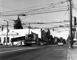
Bus turning at 41st and Dunbar
Part of Dunbar History Project fonds
Item filed under Transportation. Courtesy of Angus McIntyre.

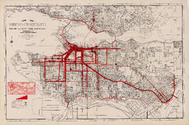
Item is a copy of a City of Vancouver Engineering Department map showing streets, railways, parks and golf courses. Indicates dedicated and undedicated streets open to traffic, streets open to restricted traffic only, and private roads.
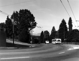
Dunbar bus line near 16th and Dunbar
Part of Dunbar History Project fonds
Item filed under Transportation. Courtesy of Angus McIntyre.

Part of William Eadington Graham fonds
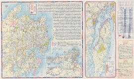
Guide map : Vancouver, New Westminster, Burnaby and North Shore municipalities
Item is a City Map and White Print Co. street map of Vancouver, Burnaby, New Westminster, North Vancouver and West Vancouver, annotated to show traffic density along major arteries. Various locations along the arteries are marked, but the significance of the markings is unclear. A small key map showing Vancouver in relation to the rest of the lower mainland has also been added to the base map.

Part of City of Vancouver Archives technical and cartographic drawing collection
Part contains a street map of downtown Vancouver, a street map of Vancouver and the Fraser Valley, detail maps showing traffic interchanges corresponding to numbers on the Fraser Valley map, and general tourist information.
Maps of Victoria and Vancouver Island, mileage chart and traffic routes
Part of City of Vancouver Archives technical and cartographic drawing collection
Part contains a street map of Victoria with street index, a map of Victoria and vicinity showing major roads, a map of Vancouver Island showing highways, a mileage chart, and traffic rules for Vancouver and Victoria.
![Miscellaneous [62 of 130]](/uploads/r/null/8/1/8188d9aec918cc18cb75058001f00de01675516acbf2c0f39f06582937e5a24c/8cb4b933-9f90-456a-ba04-5f2b46af16a0-A64395_142.jpg)
Part of City of Vancouver fonds
![Miscellaneous [63 of 130]](/uploads/r/null/9/6/96623c98a13aedc7ae70f9e6ec79ed30251102ea13173ac54eb8ed09931e6a8f/77ef8e3e-8048-4338-92b8-f5e801233b38-A64396_142.jpg)
Part of City of Vancouver fonds

One way streets : Illustrated map of Downtown Vancouver
Part of City publications collection
Part contains an illustrated map of Downtown Vancouver showing traffic flow along new one-way streets. Illustration has been annotated with address block numbers and continuations of streets directly east of Main Street.

One way streets : illustrations of special intersections
Part of City publications collection
Part contains pamphlet cover and illustrations showing traffic flow at the intersections of Robson Street and Cambie Street, Richards Street, Water Street, and Cordova Street, and Beatty Street and Pender Street
![[Parked cars and traffic along Coal Harbour drive in Stanley Park]](/uploads/r/null/c/5/c5be25876b1c17f1c614adb676f2a0f28c1d3b8df339a6e0f732ec112a8fdcd6/b428e1a2-1889-4172-b990-fb35675401e7-A10515_142.jpg)
[Parked cars and traffic along Coal Harbour drive in Stanley Park]
![[Parked cars and traffic along Coal Harbour drive in Stanley Park]](/uploads/r/null/3/3/3328d7acba0c795b9ef14261febb27a3a6b7daae5b4162bb186d02fddb876269/67cbfa8b-a88c-4c15-aed3-786c156b738a-A10516_142.jpg)
[Parked cars and traffic along Coal Harbour drive in Stanley Park]
![[Police officer, pedestrians, and traffic on Cambie Street near 12th Avenue]](/uploads/r/null/c/d/cdd1aade114ad7a3db2a6c536b43eeac4b2ba0a1739a0bbb23ad52daecc132e7/0d62707e-c9c3-46f4-a399-c5b318f73176-A13130_142.jpg)
[Police officer, pedestrians, and traffic on Cambie Street near 12th Avenue]

Streetcar at Broadway and Alma
Part of Dunbar History Project fonds
Item filed under Transportation.