![[View of East Pender Street at night]](/uploads/r/null/7/4/74ecbde63e3b15ee111f752cc895b59d5ee6630cac77ae06770c70d47789c874/f5ee10f4-9215-4ece-8efc-26a986c27303-A59340_142.jpg)
[View of East Pender Street at night]
- COV-S511---: CVA 780-475
- Item
- [between 1960-1980]
Part of City of Vancouver fonds
Photograph also shows the neon Ho-Ho Chop Suey Restaurant sign (102 East Pender Street)
72 results with digital objects Show results with digital objects
[View of East Pender Street at night]
Part of City of Vancouver fonds
Photograph also shows the neon Ho-Ho Chop Suey Restaurant sign (102 East Pender Street)

Part of City of Vancouver Archives technical and cartographic drawing collection
Item is a map of Chinatown showing streets, buildings and the number of stories in each building. Includes the area bounded by Taylor Street, Hastings Street, Gore Avenue and Keefer Street. The Provincial Historic Site Boundary, designated February 2, 1971, is drawn on the map.

Part of City of Vancouver Archives technical and cartographic drawing collection
Item is an annotated photocopy of a map of Chinatown showing streets, buildings and the number of stories in each building. Includes the area bounded by Taylor Street, Hastings Street, Gore Avenue and Keefer Street. The Provincial Historic Site Boundary, designated February 2, 1971, is drawn and indicated on the map. Notations pertaining to the boundary and the indication of the number of stories in each building appear on the map.
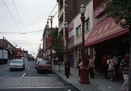
![[Pender Street in Chinatown]](/uploads/r/null/c/b/cb1d98486f1b728ae7a994d5ca397aab82be17ad425c9853e950d3d60e94a5ae/15334845-bc64-473f-8f8c-c68f0f807f2f-A16547_142.jpg)
Part of City of Vancouver fonds
Photograph shows storefronts of Yucho Chow Photograph Supply House, Canadian Scharlin Bros. Ltd. and Kwong Wing Barber Shop.
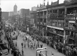
V.J. Day Chinese Dragon Parade
Photograph shows the Chinese School and Lee Buildings and the Sun Tower in the background.
Label on verso of print reads "Chinese Victory Day Celebration / The Dragon Parade / Vancouver, B.C. / August 17, 1945"

V.J. Day Chinese Dragon Parade

Yip Sang is the fifth person from the left.
![[Kuo Min Tang Chinese Nationalist League of Canada, Fourth Convention 1929, Jan. 20th to Jan. 31st]](/uploads/r/null/7/3/73285ec9ed59e296741e4058fb1e3089ddfcd91e46379adcaec57e34cd85acd9/a14bfb57-e229-4465-a9df-cebc423927bb-A72940_142.jpg)
[Kuo Min Tang Chinese Nationalist League of Canada, Fourth Convention 1929, Jan. 20th to Jan. 31st]
Item is a group portrait of men and a few children taken in front of the Manton Co. Ltd. store building at 296 East Pender Street.
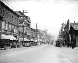
East Pender Street - Chinatown
Part of City of Vancouver fonds
Photographs shows East Pender Street with the Kam Gok Yeun Restaurant in the right foreground.

East Pender Street - Chinatown
Part of City of Vancouver fonds
Photograph shows East Pender Street and Columbia. The Sun Tower is in the background and the Chinese Benevolent Association Building is to the right.

Part of Stuart Thomson fonds

North east corner Columbia Street and Pender Street
Part of Stuart Thomson fonds
Part of Stuart Thomson fonds

Royal Bank corner of Main and Hastings
Part of Stuart Thomson fonds

Part of Stuart Thomson fonds
Also included in shot is McQueens Produce Co. Ltd.
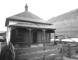
Photograph shows a small wooden house with a covered porch and a small fenced yard.
![[108 East Pender Street and 112? East Pender Street], Chinatown](/uploads/r/null/1/f/1f7a35c54945dcee9cf5150590c85a4694d3c7762a5d62efa5d0d5a7a2519e96/eaa11563-77e8-41f7-8c27-43613a47e57e-A02776_142.jpg)
[108 East Pender Street and 112? East Pender Street], Chinatown
Photograph shows Chinese Benevolent Association building, and an adjacent building, housing Oriental Art and Curios, and Ho Ho Chop Suey restaurant.
![[500 block of Carrall Street, looking north toward Pender Street]](/uploads/r/null/9/a/9a9637ab9dd6ff4452a96eae8e10ab0c3e594b6b66f64e852b56356705cbf638/f6b3daa8-b13f-4ee7-8bfd-ad0953b0e7b1-A02411_142.jpg)
[500 block of Carrall Street, looking north toward Pender Street]
Photograph shows carts, pedestrians, and buildings along the street, including the Chinese Empire Reform Association of Canada.
![[Looking north towards Pender Street along the west side of the 500 block of Carrall Street]](/uploads/r/null/9/3/93da6423bc029b02798603c4e3491c95cda7f913626589952b37f3a047ac856e/46cff22f-8189-4fae-910a-fdd17238b5e9-A02412_142.jpg)
[Looking north towards Pender Street along the west side of the 500 block of Carrall Street]
Photograph shows bicylist, carts, pedestrians, and buildings along the street.
![[Businesses and produce carts on 400 block of Carrall Street]](/uploads/r/null/b/a/ba3afb730e1d31aa6078c129eb52b155aa07a1972b6501f71677e094c1072fe6/10eb7a0e-9980-4c7f-a8eb-700e6b0a58e5-A02353_142.jpg)
[Businesses and produce carts on 400 block of Carrall Street]
Photograph shows several horse-drawn carts in front of a commercial block. Businesses in the buildings include: Kwong Fat Yuen Co., Sam Kee and Co., Sun Sun Fine Tailoring.
![[View of Dupont Street, later Pender Street, Chinatown area]](/uploads/r/null/6/0/606e8b9b8cb0818a46e021cda095c9662964079d95d2021f028ca4b94e14f67b/c1f3750a-82c7-4c2c-b0c6-f71c0fff69c5-A02361_142.jpg)
[View of Dupont Street, later Pender Street, Chinatown area]
Photograph shows carts, people, and a dog in the middle of the street. Various commercial buildings are also shown.
![[Market Alley]](/uploads/r/null/b/5/e/b5e0f5134f23640814e22d684bc2058e045d9af39bc2516503531b6b6e78eafc/e7afd632-4e33-4313-93a2-e1572569d69e-CVA260-1581_142.jpg)
Part of James Crookall fonds
Photograph shows a sign for the Sing Lung Laundry
![[Market Alley]](/uploads/r/null/0/e/8/0e8f2ace975a000fd935f4b9eef78acf661d8737a18e8c8e03180d8fac56aef5/32d8ffc9-8cba-483c-a55e-998a4bc19b41-CVA260-1545_142.jpg)
Part of James Crookall fonds
![[Crowds on Pender Street celebrating VJ Day]](/uploads/r/null/a/9/9/a991a667134ec81d73fd0e43cb35f65786fe7932651f4ad86a15bc18ec83b0ef/c475885b-6e4c-43eb-b7ab-4749b5006cfe-CVA260-1414_142.jpg)
[Crowds on Pender Street celebrating VJ Day]
Part of James Crookall fonds
Photograph shows James Crookall holding a copy of the Vancouver Sun with the headline "Official Peace"
![[A parade celebrating VJ Day on Pender Street]](/uploads/r/null/6/9/5/6950ec243113934ac6ba2b533ebb6ee37a932787e8bfdc1ce53afe22fc60297d/e0189c62-fd54-4b9a-9b3b-cb2487f6373b-CVA260-1413_142.jpg)
[A parade celebrating VJ Day on Pender Street]
Part of James Crookall fonds
Photograph shows a woman holding a copy of the Vancouver Sun with the headline "Official Peace"
![[A parade celebrating VJ Day on Pender Street]](/uploads/r/null/d/2/c/d2c624cbb295abd99dfcbce8c9a1d74acfe126849e3a820934416699ae942dfe/f70c97f4-1855-4fbd-9fae-db43dc0444e9-CVA260-1412_142.jpg)
[A parade celebrating VJ Day on Pender Street]
Part of James Crookall fonds
![[Chinese] funeral, Dupont Street (later East Pender Street)](/uploads/r/null/9/3/939dca7f6b043a4f4bd3da8ac11c8dceff7a20d780af37df7263b87af9fd713c/771f7033-ab4f-452b-975b-cae55abc7079-A70857_142.jpg)
[Chinese] funeral, Dupont Street (later East Pender Street)
Part of H.A. Price collection
Photograph shows the casket being transported in a horse drawn wagon past Fou Chong Ladies and Gents Tailor.
![[Chinese] funeral, [in the unit block] Dupont Street (later East Pender Street)](/uploads/r/null/2/7/27afba6a85132da9df669ff01695646fa82d54a8076e48ee3e158cd41bedc283/387bfc44-9c20-4616-8097-8d263c4b2117-A70541_142.jpg)
[Chinese] funeral, [in the unit block] Dupont Street (later East Pender Street)
Part of H.A. Price collection
Photograph also shows Yip Sang, second man lower left and buildings in the unit block of Dupont (East Pender Street) including the top portion of the Wing Sang building (51 East Pender).
![Beautification Problems - #1 [9 of 18]](/uploads/r/null/5/d/5dca1fe9ec7fdcddb0166393d8ebcb7c9819054ffbe43b49c8e0102918d0075e/e34cde91-7019-4f67-9a27-257b58976c42-A68611_142.jpg)
Beautification Problems - #1 [9 of 18]
Part of City of Vancouver fonds
![Beautification Problems - #1 [7 of 18]](/uploads/r/null/f/9/f9b98aefc3518bd032ac849980f288fcd965bd99fc6000fd3c3780cdaf96f6c3/280426b4-7d63-4ee2-a24f-516650a2eb0c-A68609_142.jpg)
Beautification Problems - #1 [7 of 18]
Part of City of Vancouver fonds
![Beautification Problems - #1 [8 of 18]](/uploads/r/null/6/8/68c9cbe7b96f8cce87131ae501c7c8df439c703b4576c1bf1ab9908e372a30f5/50971e31-3afa-4b89-b7f8-beb8b00db483-A68610_142.jpg)
Beautification Problems - #1 [8 of 18]
Part of City of Vancouver fonds
![Beautification Problems - #1 [3 of 18]](/uploads/r/null/d/3/d37918eff78b336271d18b497530fe3e53c7a87241747e9cff01d1879585c484/d2c9e688-d1e0-41e0-ad5e-3ff12bf04fe7-A68605_142.jpg)
Beautification Problems - #1 [3 of 18]
Part of City of Vancouver fonds
![Miscellaneous [109 of 130]](/uploads/r/null/b/1/b1fc79bd50c6d7638eb43a204f4f9905534e9fc0637359fb4d73ab9ab40d0f24/844caafa-0f63-43f1-846e-ca75e012ca62-A67541_142.jpg)
Part of City of Vancouver fonds

Part of City of Vancouver fonds
![Local Improvements [10 of 11]](/uploads/r/null/e/c/ecadaccfde51ff99da8a8377e926c9a7026763ccb3d4d808f2ad51dd5f3819b3/1a3482f5-5161-41dc-896e-bad89ca55f31-A66576_142.jpg)
Part of City of Vancouver fonds
![[Mel Yip standing in front of window of the Wing Sang Company Building at 51 East Pender Street]](/uploads/r/null/b/0/b0cf0dc2bc938d7e5866b6a80e3535a06ddc5f4c74ba218f7f3bc673b5805dc1/8866a29f-8d1c-4e41-977a-6e4a4430b8cd-A70544_142.jpg)
[Mel Yip standing in front of window of the Wing Sang Company Building at 51 East Pender Street]
Mel Yip is a grandson of Yip Sang.
![[Looking west from Main Street along the 100 Block of East Pender Street]](/uploads/r/null/6/b/6bb6339b8a98b030d2058b44345d057f6722c1ca1c88073fc820a42cecb63554/2012b211-0c2b-4a3f-8668-15e901e335bc-2011-068_142.jpg)
[Looking west from Main Street along the 100 Block of East Pender Street]
Photograph shows Bamboo Terrace, Mings, Chung King Chop Suey and other businesses and the Sun Tower in the background
![[Buildings on the north side of the 100 Block of East Pender Street]](/uploads/r/null/d/d/dd653bb6cf20b79e113c193fdff90700a64dfbc000b2bbb2fbde65c680623154/01490dd3-0d22-42c9-bddc-2c00ef5d4706-2011-068_142.jpg)
[Buildings on the north side of the 100 Block of East Pender Street]
Photograph shows part of the Chinese School building and the Lee Building
![[123 East Pender Street, Mon Keang School]](/uploads/r/null/4/1/41c77cc48f29b76316f4e0d93011dd2278ce280fc03705c93bad1698e836a43e/5b9244b7-1648-442f-9dfd-d921a5d63b6d-A70080_142.jpg)
[123 East Pender Street, Mon Keang School]
Part of William Eadington Graham fonds
![Tel[ephone] kiosk](/uploads/r/null/8/5/854985ab008ab8020a24d231cc8b49f59ade264fdd469ac84a788ee1f3f5f5df/9405472d-e26a-4a99-bf03-6b5cdb78890c-A59346_142.jpg)
Part of City of Vancouver fonds
Item is a photograph of a Chinese-styled telephone booth.
![[View of East Pender Street at night]](/uploads/r/null/4/5/4567057890860c08ba1bd0789387e24d2f94dd1dbf88cdd5f58182807913d83a/ae901d04-cea5-46c8-978c-acfe01af9c6e-A59341_142.jpg)
[View of East Pender Street at night]
Part of City of Vancouver fonds
Item is a photograph of buildings and businesses along Pender Street including Ming's Restaurant (147 East Pender Street) and the Sun Tower (100 West Pender Street); neon signs are visible.
![[Group photograph of boys and young men on Pender Street]](/uploads/r/null/8/c/8cb05aecad43407aaf38f453abe31901d9ea9bfb67c7c66308c5739f1d4c0e48/ae888492-e49c-4add-84a6-7b7df43203ea-A72201_142.jpg)
[Group photograph of boys and young men on Pender Street]
Photograph shows a large group of boys and young men (some in scout uniforms) standing on Pender Street. The Peking Chop Suey House in the Chinese Freemason's Building at 1 West Pender Street appears in the background. Approximately half of the photograph is missing.
![[Yip Sang with children and family members in front of Wing Sang Company building at 51 East Pender]](/uploads/r/null/f/4/f4e0f636f02f8bf3f04800aa5fa69e34f3a54ca31bcd7af362a1961e71b04f9e/ba070627-f845-473d-9018-3ab7c409260c-A72190_142.jpg)
[Yip Sang with children and family members in front of Wing Sang Company building at 51 East Pender]
Item is a photograph of a photograph showing the Wing Sang Building prior to its expansion in 1901. Individuals identified are: Yip Sang (far left), his number seven son Yip Kew Hong (holding Yip Sang's hand) and his number six son Yip Kew Gin (second from the right).

Photograph shows the Wing Sang Building prior to its expansion in 1901. Yip Sang is on the far left.
![[Canton Alley]](/uploads/r/null/8/8/8854bad410df2a72779b09bd8a9091d40f6289e711835cb4bbd085afd90b6428/3e85ba2f-44e4-4064-ade5-a4a17ac6c346-A63452_142.jpg)
![View of Main [Street] and Pender [Street] inter[section] from 100 block Pender [Street]](/uploads/r/null/2/2/224af7459e895153a2041251eba0bd96405a995510e243a26009d9d3296cce79/157f22c9-caac-4540-801c-f5eb96ad78a6-A59345_142.jpg)
View of Main [Street] and Pender [Street] inter[section] from 100 block Pender [Street]
Part of City of Vancouver fonds
![[View of East Pender Street at night]](/uploads/r/null/4/7/472e36804ff8b8b973a69d97343b6b23df959c448fcecfcdc8da81499bb8ed50/734f9b9c-1c06-4273-b792-d1fa7a840e10-A59343_142.jpg)
[View of East Pender Street at night]
Part of City of Vancouver fonds
Photograph also shows buildings and businesses along Pender Street including the Bamboo Terrace Restaurant (155 East Pender Street), Ming's Restaurant (147 East Pender Street), and the Sun Tower (100 West Pender Street)
![[The Royal Bank of Canada at 400] Main [Street]](/uploads/r/null/3/1/31b178a91e7348d2de6feb9d95952c62c2c18be8c121d855bf053bc1ea11b6a8/b66308ef-73d7-4f77-b104-2b1eed777693-A59342_142.jpg)
[The Royal Bank of Canada at 400] Main [Street]
Part of City of Vancouver fonds
![[Street in Chinatown]](/uploads/r/null/7/9/79304d705765515f8c1fab72b5a2ae9346fa227f62882074a2d9538a7edb131c/cc57fe39-8ba1-4a37-9e00-78bd45793a97-A59339_142.jpg)
Part of City of Vancouver fonds
Photograph also shows Marshall Wells Limited (549-573 Carrall Street)
![[View of the 100 block East Pender Street]](/uploads/r/null/9/e/9e8996571e649a6910459ecf12df1286ad79a82f4ab904dcd921f258254d920e/ead7e79f-1461-4feb-9201-f40e0c8cf168-A59338_142.jpg)
[View of the 100 block East Pender Street]
Part of City of Vancouver fonds
Photograph shows 116 East Pender Street, the Chinese Benevolent Association (108 East Pender Street) and the Sun Ah Hotel (100 East Pender Street)