
- COV-S597-F1-: 2019-102.07
- Item
- June 1975
Part of City of Vancouver fonds
Item is a photograph showing the marina looking northwest with the Burrard Bridge in the background.
943 results with digital objects Show results with digital objects
Part of City of Vancouver fonds
Item is a photograph showing the marina looking northwest with the Burrard Bridge in the background.

Part of City of Vancouver fonds
Item is a photograph showing the marina looking northwest with the Burrard Bridge in the background.

Part of City of Vancouver fonds
Item is a photograph showing the view from Anderson Street at Granville Island looking west towards the 1500 block of Island Park Walk. Boats are also shown in Fishermen's Wharf.

Part of City of Vancouver fonds
Item is a photograph showing the view from the seawall at the 1500 block of Island Park Walk. Boats are also shown in Fishermen's Wharf.
![Fir [Street] and 4[th Avenue intersection, 3 of 4]](/uploads/r/null/3/4/7/347fbe61da599fc949abd73351c74c6b903e6281d414326d457f6baad11d9a2f/b525cf91-6509-4e27-8a3d-485434091a32-2019-103.0642_142.jpg)
Fir [Street] and 4[th Avenue intersection, 3 of 4]
Part of City of Vancouver fonds
![Fir [Street] and 4[th Avenue intersection, 4 of 4]](/uploads/r/null/e/9/e/e9e89e26eff0765d776e5f8b453182b7df6c5243b7df25f40f07824906ab6b65/a3445d86-40e8-4592-b6cc-ec10063bb8e6-2019-103.0644_142.jpg)
Fir [Street] and 4[th Avenue intersection, 4 of 4]
Part of City of Vancouver fonds
![[North-bound view of Stanley Park Causeway]](/uploads/r/null/3/7/c/37c7c88cab0cca4dbf7f18a14d422b08eac593f411b9d187b7c44cf6ea7b99c7/61696b28-0fda-4920-ad1b-6b05335a248e-CVA1095-00566_142.jpg)
[North-bound view of Stanley Park Causeway]
Part of City of Vancouver fonds
![[View of Lions Gate Bridge from Stanley Park]](/uploads/r/null/6/5/e/65eb22cd806d83d976f34f90d16e6df9e406ea4f2cd42f9d8e6cc713442a4435/ed2e6151-010e-4037-ba31-74c9758b7909-CVA1095-00567_142.jpg)
[View of Lions Gate Bridge from Stanley Park]
Part of City of Vancouver fonds
![[North end of Oak Street Bridge]](/uploads/r/null/6/c/8/6c8815bc29a455f7a6869e35447b02eb51b787bd3ef8b350a847151c0733854c/89154a87-8e10-4335-b196-a90a2912a63a-CVA1095-01088_142.jpg)
[North end of Oak Street Bridge]
Part of City of Vancouver fonds
View of the Oak Street Bridge taken from Eburne Park.
![[Dedication plaque for the construction of the Burrard Bridge]](/uploads/r/null/7/7/d/77d318c0c5187a095acee61542bcf9469ba4c742074f0269c3523cc19cccf652/4fbaafd9-5f36-46f0-9cdd-859773a27632-CVA1095-01166_142.jpg)
[Dedication plaque for the construction of the Burrard Bridge]
Part of City of Vancouver fonds
![[North end of Burrard Bridge]](/uploads/r/null/8/8/d/88df8cb35881fa60d8534635db1ddc94dbaf003a3dd6383e9fad02e549501cdb/3fbd50bd-7899-4556-acc2-f2f3966c8e4e-CVA1095-01167_142.jpg)
Part of City of Vancouver fonds
Item is a photograph that depicts a view looking south over the Burrard Bridge.
![[View of BC-99 and Oak Street Bridge]](/uploads/r/null/4/5/8/458b5c3aa806b1876ce89d19c5995c3674bf2f5ce63fef81450a44a02f73f06e/69af4c29-e135-4608-9de7-23b4220e84db-CVA1095-02761_142.jpg)
[View of BC-99 and Oak Street Bridge]
Part of City of Vancouver fonds
![[1010 Beach Avenue - Essington Seafood Restaurant]](/uploads/r/null/8/d/7/8d7bc1e891340ef66dcf7e81148ced311fe0f2875e0f2ea854fb9304e71b8bf3/d8ba7a78-1193-4249-9a71-8ef9f93b3d8c-CVA1095-06514_142.jpg)
[1010 Beach Avenue - Essington Seafood Restaurant]
Part of City of Vancouver fonds
![[View southwest from Oak Street Bridge, 1 of 5]](/uploads/r/null/a/9/4/a94e0e3d0d3d39d5131673b634304dd181cada1d6e2ff3e2c4fd2515657a3e7f/7b14a261-66b3-46ce-b707-dbdb4b8625f9-CVA1095-07206_142.jpg)
[View southwest from Oak Street Bridge, 1 of 5]
Part of City of Vancouver fonds
![[View of industrial lots and Oak Street Bridge]](/uploads/r/null/8/0/9/8096f58aa5ccedbb062a4543b4c18a785dd65508fb988a993beab06159b1a40e/799e1642-30ea-4f93-a844-ece853314904-CVA1095-07262_142.jpg)
[View of industrial lots and Oak Street Bridge]
Part of City of Vancouver fonds
![[View of industrial buildings and Oak Street Bridge]](/uploads/r/null/b/9/b/b9b1054fad0b2e80f94276ea3fa24e412dafa55084b05c52f8a5b632611eb1e5/5179aac2-ed62-4e53-a747-8c7ebe7237a0-CVA1095-07263_142.jpg)
[View of industrial buildings and Oak Street Bridge]
Part of City of Vancouver fonds
![[Keefer Street parking lot, 1 of 2]](/uploads/r/null/b/8/f/b8fcc8fbb02c370b4e1b9f8b5fdb4129ffad0bf1fe29aa70b6a164f47043fb97/e35ef3f6-f7b3-4e89-8b5b-52f2bc7ba9c9-CVA1095-08565_142.jpg)
[Keefer Street parking lot, 1 of 2]
Part of City of Vancouver fonds
Item is a photograph that depicts a parking lot in front of an overpass.
![[Keefer Street parking lot, 2 of 2]](/uploads/r/null/8/8/c/88c9b96a18916fc7c901bd97e5072ad287046681b615277fb36dc4fe3a3953ac/5ec0cbf6-ecd6-4f1c-b1a4-8552746194b6-CVA1095-08566_142.jpg)
[Keefer Street parking lot, 2 of 2]
Part of City of Vancouver fonds
Item is a photograph that depicts a parking lot with a sign for the Vanport Hotel visible behind it.
![[Buildings and bridge, 1 of 2]](/uploads/r/null/4/b/7/4b746d60a5edcad5541e0ec05bcd8d839b4335381479f366269d050f7f1df6b9/98aa5923-5c95-49ce-b711-4724c905436c-CVA1095-14682_142.jpg)
[Buildings and bridge, 1 of 2]
Part of City of Vancouver fonds
![[Buildings and bridge, 2 of 2]](/uploads/r/null/2/3/3/233119e90a202a70b6aaf8538578b58683dc17af05d65653af449d9b3aa593ea/28d287c7-9b0d-4bdd-a364-ac4123dd1f72-CVA1095-14683_142.jpg)
[Buildings and bridge, 2 of 2]
Part of City of Vancouver fonds
![[Burrard Street Bridge, 1 of 3]](/uploads/r/null/8/2/7/8272b00c7778bee0357fc7fdaeb93e9009fb5d4ad2b00865251e9730d3fd3666/d74bdc73-21ac-4cbe-a77f-aefb7ea6e743-CVA1095-15066_142.jpg)
[Burrard Street Bridge, 1 of 3]
Part of City of Vancouver fonds
![[Burrard Street Bridge, 2 of 3]](/uploads/r/null/b/7/1/b71695b76d79c18cfe3eca173064b375f56c794b93c98642faf7bf8753a0845a/703e5e4b-b9be-424d-a557-3bddc16cdf6b-CVA1095-15068_142.jpg)
[Burrard Street Bridge, 2 of 3]
Part of City of Vancouver fonds
![[Burrard Street Bridge, 3 of 3]](/uploads/r/null/1/d/7/1d744db11b4d7423fbffc805972c5694e3a1fab315ac73ae3ae3f7f6205014ae/620998a7-dd5f-4266-ae95-45faccfd905f-CVA1095-15069_142.jpg)
[Burrard Street Bridge, 3 of 3]
Part of City of Vancouver fonds
![[View looking south from the north end of the second Granville Bridge]](/uploads/r/null/a/c/acf4d1c8aea3aa91ce69f0e772e25c42e06280ab6fdc8ffd7237b665cecdbe3a/5747d652-05a3-4b69-95e4-8849829ea0ae-A47613_142.jpg)
[View looking south from the north end of the second Granville Bridge]
Part of City of Vancouver fonds
Photograph shows part of the Continental Hotel and the National Furniture clock
Part of City of Vancouver fonds
Part of City of Vancouver fonds

Part of City of Vancouver fonds

Part of City of Vancouver fonds
Boats on shoreline under north end of Burrard Bridge
Part of City of Vancouver fonds

View looking east toward Granville Bridge
Part of City of Vancouver fonds
Item is a photograph showing the shoreline underneath the Burrard Bridge and the view looking east toward Granville Bridge; taken from under north end of Burrard Bridge.

View of shoreline from Burrard Bridge
Part of City of Vancouver fonds
Item is a photograph showing a view looking down on shoreline from Burrard Bridge at the foot of Beach Avenue on east side of Burrard Bridge.

Partial view of shoreline from Burrard Bridge
Part of City of Vancouver fonds
Item is a photograph showing a partial view looking down on shoreline from Burrard Bridge at the foot of Beach Avenue on east side of Burrard Bridge.

Partial view of shoreline under Burrard Bridge
Part of City of Vancouver fonds
Item is a photograph showing a partial view of shoreline under north end of Burrard Bridge.

View of buildings on shoreline from Burrard Bridge
Part of City of Vancouver fonds
item is a photograph showing the foot of Beach Avenue, the shoreline on the north side of Burrard Bridge and Granville Bridge to the east.

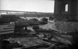
View of boats and debris under Burrard Bridge
Part of City of Vancouver fonds
Item is a photograph showing a cluster of boats, sheds and debris at the foot of Beach avenue, taken from Burrard Bridge.
![[Aerial view looking west over Granville Island]](/uploads/r/null/d/5/d5e5021eedf545a1ee16153e245643d67a63469ee5d43b1eeee58dd438678103/8fac530f-b053-43dc-9ffa-94995fd358d1-A49645_142.jpg)
[Aerial view looking west over Granville Island]
Part of City of Vancouver fonds
Oblique view showing the Granville Bridge, the Kitsilano Trestle Bridge, the Burrard Bridge and log booms in False Creek

Part of City of Vancouver fonds

Part of City of Vancouver fonds
Item is a photograph showing a rescue attempt underway on First Narrows Bridge.

Part of City of Vancouver fonds
Item is a photograph showing a rescue attempt underway on the First Narrows Bridge.

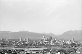
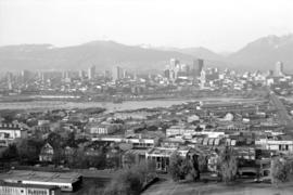
Downtown cityscape over Mount Pleasant, Fairview, and False Creek
Part of City of Vancouver fonds
Item part is a photograph of downtown Vancouver, including a view down Cambie Street across the Cambie Street Bridge, and adjacent neighborhoods in Fairview and Mount Pleasant.

Downtown cityscape over Mount Pleasant, Fairview, and False Creek
Part of City of Vancouver fonds
Item part is a photograph of downtown Vancouver, including a view down Cambie Street across the Cambie Street Bridge, and adjacent neighborhoods in Fairview and Mount Pleasant.

Downtown cityscape over Mount Pleasant, Fairview, and False Creek
Part of City of Vancouver fonds
Item part is a photograph of downtown Vancouver, including a view down Cambie Street across the Cambie Street Bridge, and adjacent neighborhoods in Fairview and Mount Pleasant.
Downtown cityscape over Mount Pleasant, Fairview, and False Creek
Part of City of Vancouver fonds
Item part is a photograph of downtown Vancouver, including a view down Cambie Street across the Cambie Street Bridge, and adjacent neighborhoods in Fairview and Mount Pleasant.

Downtown cityscape over Mount Pleasant, Fairview, and False Creek
Part of City of Vancouver fonds
Item part is a photograph of downtown Vancouver, including a view down Cambie Street across the Cambie Street Bridge, and adjacent neighborhoods in Fairview and Mount Pleasant. The Granville Street Bridge and the Burrard Street Bridge are visible at the far left.

Downtown cityscape over Mount Pleasant, Fairview, and False Creek
Part of City of Vancouver fonds
Item part is a photograph of downtown Vancouver, including a view down Cambie Street across the Cambie Street Bridge, and adjacent neighborhoods in Fairview and Mount Pleasant.

Downtown cityscape over Mount Pleasant, Fairview, and False Creek
Part of City of Vancouver fonds
Item part is a photograph of downtown Vancouver, including a view down Cambie Street across the Cambie Street Bridge, and adjacent neighborhoods in Fairview and Mount Pleasant.
Downtown cityscape over Mount Pleasant, Fairview, and False Creek
Part of City of Vancouver fonds
Item part is a photograph of downtown Vancouver, including a view down Cambie Street across the Cambie Street Bridge, and adjacent neighborhoods in Fairview and Mount Pleasant.

Downtown cityscape over Mount Pleasant, Fairview, and False Creek
Part of City of Vancouver fonds
Item part is a photograph of downtown Vancouver, including a view down Cambie Street across the Cambie Street Bridge, and adjacent neighborhoods in Fairview and Mount Pleasant.