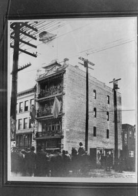
![[Chinese] funeral, [in the unit block] Dupont Street (later East Pender Street)](/uploads/r/null/2/7/27afba6a85132da9df669ff01695646fa82d54a8076e48ee3e158cd41bedc283/387bfc44-9c20-4616-8097-8d263c4b2117-A70541_142.jpg)
[Chinese] funeral, [in the unit block] Dupont Street (later East Pender Street)
- AM358-S1-: CVA 152-79
- Item
- [ca.1889], copied 1996
Part of H.A. Price collection
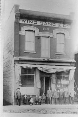
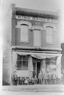
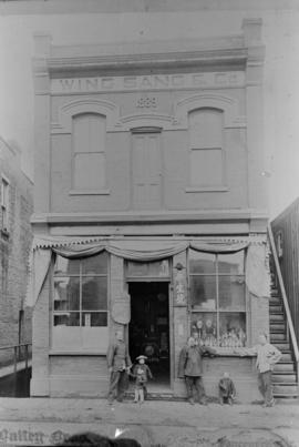
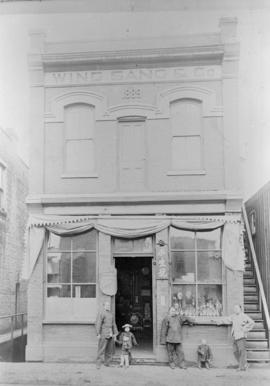
Photograph also shows Yip Sang, second man lower left and buildings in the unit block of Dupont (East Pender Street) including the top portion of the Wing Sang building (51 East Pender).
![[Chinese] funeral, Dupont Street (later East Pender Street)](/uploads/r/null/9/3/939dca7f6b043a4f4bd3da8ac11c8dceff7a20d780af37df7263b87af9fd713c/771f7033-ab4f-452b-975b-cae55abc7079-A70857_142.jpg)

![[View of a large building, possibly a school]](/uploads/r/null/9/c/9c6d7582f292818dce4c71d56b5294775e82ba1128cb6b89062718ff736e2943/fea18c89-ebb2-456f-b2bf-abcd82a7fc59-A72148_142.jpg)
![[View of people standing in front of some buildings]](/uploads/r/null/8/e/8e134d5bd48218204d177e24e11dc672f95da300d046c3a22c5bd967bd68965f/7fd2eee3-260c-4f62-9340-6e6fccba5207-A72147_142.jpg)
![[View of building]](/uploads/r/null/4/e/4ed7f12ebba48b897567090a2463650ca2b2043ed796de794fa4e77d1c8eeef0/7bdf69f5-50d3-4114-8159-fe64800aa415-A72149_142.jpg)
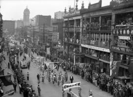
![[Parade in Chinatown on Fisgard Street, Victoria B.C.]](/uploads/r/null/d/f/df52ac83c2a724922392475c57efacc14d06832497a4c5673ef0b80809f3768f/b94bfbbd-e552-4a4f-bb46-8929393fd8f4-A37334_142.jpg)


![[View of corner of shallow building at Pender and Carrall Streets]](/uploads/r/null/5/b/5bb89725538db2f3552a7f75247d566e687aa70959379566c8136990b3e1fbca/47fec339-a695-479e-8998-af4e74e7d3d4-A08842_142.jpg)
![Class of 1936, slide-tape show [23 of 67]](/uploads/r/null/2/2/7/22750fe981b0045edd717111694083543b629d6e7b84adb258872e80c784ba8b/fc6ee310-2cf6-4911-8303-1280c04499e6-2008-010_142.jpg)
![Class of 1936, slide-tape show [24 of 67]](/uploads/r/null/3/f/e/3feae53821d35c8c43cd38c11c96daba1a6053b26ebabdb57b61a5e74299afa3/0558619f-afdc-46a4-b28c-10353a4e05ba-2008-010_142.jpg)
![Class of 1936, slide-tape show [61 of 67]](/uploads/r/null/9/b/9/9b90eda8abaaed606fbdfab6c5265992e5199f3027dd7ba4bdfc3ae6125d0ea3/c532fdc3-c599-4c74-8c46-1a1d585cda60-2008-010_142.jpg)
![Old Bldg. in Chinatown [Pender St. and Shanghai Alley]](/uploads/r/null/3/3/33f4fff712ef2e431e582e7b9a98f418829fcea9d7642e18d0c079405b95b015/02242b59-6e20-462a-9388-e82f3519704a-A21596_142.jpg)
![[View of the 100 block East Pender Street]](/uploads/r/null/9/e/9e8996571e649a6910459ecf12df1286ad79a82f4ab904dcd921f258254d920e/ead7e79f-1461-4feb-9201-f40e0c8cf168-A59338_142.jpg)
![[266-268 East Pender Street - Seasonal Seafood Market and Dollar Meet Store]](/uploads/r/null/a/2/1/a211a1b66aa1b4e8159ea87771215baf32aac4fbe7481423f43a896ca206fa9b/16b55aa0-d73a-40ac-91ea-ad985a436dbe-CVA1095-08648_142.jpg)
![[252-256 East Pender Street - Le Kiu Importing Co. Ltd. and Jade Palace Restaurant]](/uploads/r/null/4/5/1/4518d4cfb881fe333f7a32475a9230de3e5fcb11f1eaef5519fb806f7206e5da/6c6476ff-d975-4d12-88a2-69a892bbda8b-CVA1095-08652_142.jpg)
![[256-264 East Pender Street - Le Kiu Importing Co. Ltd., Wankow Travel and Hotel Sydney]](/uploads/r/null/5/2/4/524b83fedeb2ea90fa543fa312cf955a1f6791c176af13094c3739550b62284c/388a68f2-ee7e-47fb-9869-954c03f50073-CVA1095-08650_142.jpg)

![[280-288 East Pender Street - Pender Seafoods Limited, Wing Hing Co. Ltd.]](/uploads/r/null/b/d/1/bd10eb42ff9273c8bd6cdbe921de97dbced0a57ae14b564e4034d9689b1abfea/13f1a20c-2bbb-491c-b297-0732592f24d8-CVA1095-08654_142.jpg)
![[280 East Pender Street - Wing Hing Co. Ltd.]](/uploads/r/null/5/2/f/52f23ebb7856cc2c1f8a2ccd2fe41c11a6560020252a99169a971464c74c0ee7/4536ec91-afa9-4ad2-8f18-8f197955a566-CVA1095-08655_142.jpg)
![[276-278 East Pender Street]](/uploads/r/null/7/a/f/7af7bb3208c9283745f32a7ef1e035fa947d007c9e0807137ebff916669c9460/2bc621a4-3ab5-4dc8-93d2-8f2b5f84f449-CVA1095-08656_142.jpg)
![[View of East Pender Street]](/uploads/r/null/f/5/f5fd6eb10ecf9a112b56291868c4ca0d1f30fb9b406a719b8443330dbffb4916/b5457b24-3eb1-4f92-9bcc-877ce6d12f62-A59321_142.jpg)
![[Street in Chinatown]](/uploads/r/null/7/9/79304d705765515f8c1fab72b5a2ae9346fa227f62882074a2d9538a7edb131c/cc57fe39-8ba1-4a37-9e00-78bd45793a97-A59339_142.jpg)
![[Chinatown intersection]](/uploads/r/null/8/b/d/8bdbd28200959b797a94cbdeb30e65127da1bbaf3256587883173873dced44b4/61175fe6-ff1f-4834-84a6-92bddb277ab8-CVA1095-08658_142.jpg)