
Mount Baker, from Victoria, B.C.
- AM1052-: AM1052 P-871
- Item
- 1919
Item is a postcard printed with an image of a painting depicting Mount Baker as seen from the water near Victoria, B.C.
127 results with digital objects Show results with digital objects
Mount Baker, from Victoria, B.C.
Item is a postcard printed with an image of a painting depicting Mount Baker as seen from the water near Victoria, B.C.
![[Lake Terrell in Whatcom County]](/uploads/r/null/2/2/2223e2313d4eb14277ea1f4ce3a6deab7ce88c988a6a741e894d461b467c2d2b/1e783d26-377f-4cfa-9940-0c8a79154760-A33354_142.jpg)
[Lake Terrell in Whatcom County]
Part of Major Matthews collection
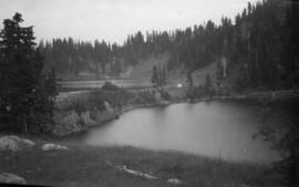
Twin Lakes from Mt Winchester, Mt Baker National Forest
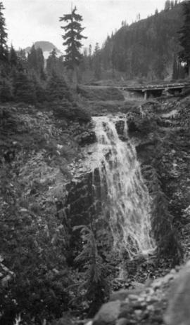
Galena Falls - Mt Baker National Forest

Wildlife : Hurricane Ridge, olympic marmot
![Veratrum [at] Mount Baker, Washington](/uploads/r/null/9/c/9c38d8792e2c86902dfa539e3525cd77be414e011c9d1cb0f371b8c9955f3f75/086b1136-c8a9-4d27-abb1-601c25f41ce1-A58335_142.jpg)
Veratrum [at] Mount Baker, Washington
![Phyllodoce empetriformis, Hurricane Ridge - Olympic Pen[insula]](/uploads/r/null/e/2/e2214854c50ece5526d274af6b748ec02f81df8f96d535fc5831ecd0e298f7ce/c231e151-61e8-4dfb-b2e4-4f15c426fce0-A57201_142.jpg)
Phyllodoce empetriformis, Hurricane Ridge - Olympic Pen[insula]
![Orthocarpus imbricatus : owl's clover [at] Hurricane Ridge](/uploads/r/null/2/3/23d6ad2373cdf9b28420acef1c262e781de9e62098aa8ac5edc6160421f07ce5/21890175-83db-46ce-83f3-bdc27c9a7246-A56773_142.jpg)
Orthocarpus imbricatus : owl's clover [at] Hurricane Ridge

Galena Creek, Mt Baker National Forest Reserve
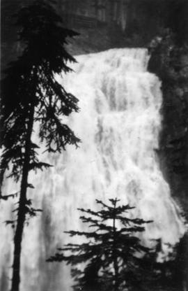
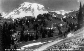
In Mount Rainier Park : Narada Falls
Part of William Orson Banfield fonds

In Mount Rainier Park : Narada Falls
Part of William Orson Banfield fonds

In Mount Rainier Park : Paradise Inn in winter, Rainier National Park
Part of William Orson Banfield fonds
![In Mount Rainier Park : getting it out [removing the snow from Myrtle Kilpatrick's neck]](/uploads/r/null/b/5/7/b57ced6faca5ae521a5f70775d7e5b175888475207ac9cf13d2899cdd47448a7/2348fbb4-f1dc-4db7-a08a-d72a67b9d9ca-CVA289-002_142.jpg)
In Mount Rainier Park : getting it out [removing the snow from Myrtle Kilpatrick's neck]
Part of William Orson Banfield fonds
In Mount Rainier Park : On Alta Vista near the Paradise Inn
Part of William Orson Banfield fonds
![The road at summit [of] Blewet Pass](/uploads/r/null/8/7/a/87af9a01f91e6a639af597d399c2e04b941e6bb36f49e35531f96a2c196a342f/6eb5986e-f3e3-4be3-8663-3b8cfd485586-CVA289-004_142.jpg)
The road at summit [of] Blewet Pass
Part of William Orson Banfield fonds
![[Columbia Gorge Hotel] and garden](/uploads/r/null/e/e/2/ee2003be0ffaf1d109c4a8fc42712c58d3411c739f7509ef851cd46f055fb8f2/f39d9893-f052-4b8e-a999-d012268b5c59-CVA289-004_142.jpg)
[Columbia Gorge Hotel] and garden
Part of William Orson Banfield fonds
![Cloud Cap Inn, M[oun]t Hood](/uploads/r/null/c/3/1/c312ea1285c10b4806d007ac20223e4d5e45ff822506f5a5913446df5899e1bc/bb39cd62-e9bf-449a-b9bc-4050c2712672-CVA289-004_142.jpg)
Part of William Orson Banfield fonds
![M[oun]t Hood](/uploads/r/null/f/f/a/ffa40e15d75e58107cf469529306b57965f1d07e8852c92312aa0e657790e20d/f2d5e63d-7a89-4e1d-a7ba-7d56f8254194-CVA289-004_142.jpg)
Part of William Orson Banfield fonds

Part of William Orson Banfield fonds

Part of William Orson Banfield fonds

Part of William Orson Banfield fonds

Part of William Orson Banfield fonds
![View on the Chuckanut Drive, Pacific Hiway [Highway]](/uploads/r/null/0/a/1/0a1f1953636564ca1646814e64cd543aec5e12b70d12d5ead5e12114ec2165d1/feb53896-e5dd-42a0-855f-c0967c781f64-CVA289-003_142.jpg)
View on the Chuckanut Drive, Pacific Hiway [Highway]
Part of William Orson Banfield fonds
![Oroville, Wash[ington] from Anarchist M[oun]t[ain]](/uploads/r/null/c/6/c/c6cbb9de05dfd059413bfe53f740e3b92cbd2c230b73741ec481cea5e1e9694e/8de554c5-6470-4bc5-bb0a-675aef0b0760-CVA289-005_142.jpg)
Oroville, Wash[ington] from Anarchist M[oun]t[ain]
Part of William Orson Banfield fonds
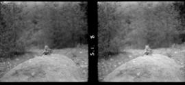
![2 Deer Longmire [Mt. Rainier]](/uploads/r/null/5/2/3/523908f1e38ee7cb8afbbf7146607455413eb367b90b3b9b2154c3c04686c134/fbd86f4e-9609-40c5-90fb-f0b4722639ee-CVA260-2078_142.jpg)
Part of James Crookall fonds
![Mount Rainer across from [Rim] at Longmire [bridge in photo]](/uploads/r/null/6/1/b/61b2f62a0ce21b38f293d3758843df208ea12fc67b064ab6973c20ed6abc283a/31880743-04b2-4cc9-a3b2-c6153baf5c38-CVA260-2082_142.jpg)
Mount Rainer across from [Rim] at Longmire [bridge in photo]
Part of James Crookall fonds
![Narada Falls [Mt. Rainier]](/uploads/r/null/b/7/a/b7a75a964b21a52015369b4b03528d136a704030a66c9ea4259be97bfcd557be/64fdb4a2-9802-4cdb-b36d-8b2c4febcea2-CVA260-2087_142.jpg)
Part of James Crookall fonds
Part of James Crookall fonds

Part of James Crookall fonds

Part of James Crookall fonds
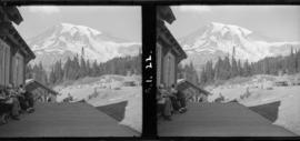
Tatoosh Range from lodge verandah
Part of James Crookall fonds
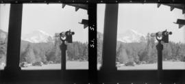
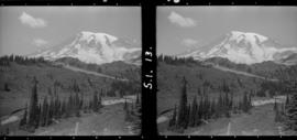
Mount Rainier from Longmire (telescope)
Part of James Crookall fonds
Part of James Crookall fonds

Part of James Crookall fonds

Part of James Crookall fonds

Part of James Crookall fonds
![[The entrance to Fairhaven Park]](/uploads/r/null/d/1/d1bce377719fe72a83156fee9aea583aace0164cc961d110e6a8551a35571d1a/9c2c756b-94f8-4b17-9397-2c86e0a87287-A26812_142.jpg)
[The entrance to Fairhaven Park]
Part of Major Matthews collection
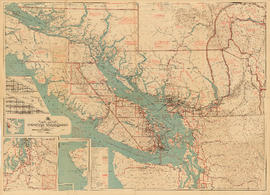
Part contains a commercial and visitors map of the southwestern land districts of British Columbia, encompassing Vancouver Island and the mainland from Seymour Inlet in the northwest to Black Pines in the northeast, extending south to Chiwaukum, Washington. Primary map shows settlements, government agent offices, mining and sub-mining recording offices, game reserves, customs posts, hospitals, ferries, campsites, golf courses, canneries, commercial air harbours, lighthouses, radio stations, motor boat refill stations, power sites, railways, roadways, trails, telegraph and telephone lines, steamship routes, topographic contour lines, and locations of falls and rapids. Text on the map provides information on land features and the presence of wild and farmed animals, and indicates current and possbile agricultural and industrial land use. Inset maps show the northern tip of Vancouver Island, Triangle Island and West and East Haycock Islands, and northwestern Washington State from Seattle to Centralia. A key map shows the location of the area covered by the main map in relation to the rest of North America.

South western British Columbia
Item is a map of southwestern British Columbia and northwestern Washington showing cities, municipalities, and settlements, post offices, government agents, railways, roads, ferry and steamship routes, air and seaplane ports, parks, campsites, glaciers, customs ports of entry, and elevations of mountains. Inset maps show the islands north of Cape Scott and the Seattle region. An small key map shows the primary map's location in relation to the rest of British Columbia and other maps published in the same series.
![[View of Mount Shuksan from the road to Mount Baker]](/uploads/r/null/d/7/d77b6396eecb2d0f09fe1df0a14704f25d6a92df9eb23bf1fc9adae7a87adaa0/b0cecf3c-95b9-48e0-81cf-a5524cdb66dc-A32833_142.jpg)
[View of Mount Shuksan from the road to Mount Baker]
Part of Major Matthews collection
![Vaccinium [at] Mount Baker, Washington](/uploads/r/null/3/3/338e12c80bcf0050cb72f9fee4dcc07a6d63e1e11fe4ae1e46a591e9f9700888/539c7e4f-1a83-4682-930e-c61019972a0b-A58319_142.jpg)
Vaccinium [at] Mount Baker, Washington
![Veratrum [at] Mount Baker, Washington](/uploads/r/null/8/0/80c95d684d66b84d35f9ff795d098fae90d542e9efd215455c701df685169c6d/051712fc-6b92-478a-a2e6-ece0f2ecf2ba-A58334_142.jpg)
Veratrum [at] Mount Baker, Washington

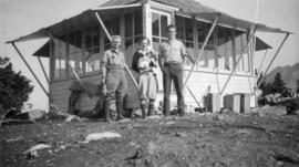
Forestry Lookout, Mt Winchester, Mt Baker National Forest Reserve, Washington
![Our motor trip to Portland : Gwyn [Lewis] going-?](/uploads/r/null/8/3/b/83b79ca98cce8ab981f140f211393d57c9cd253d7d73733be3851a3532f3812b/67dc7352-e7d3-4333-a203-7e21500c0903-CVA289-002_142.jpg)
Our motor trip to Portland : Gwyn [Lewis] going-?
Part of William Orson Banfield fonds

In Mount Rainier Park : The road to Paradise Inn, winding up the hill side
Part of William Orson Banfield fonds
In Mount Rainier Park : The Narada River below the falls
Part of William Orson Banfield fonds

In Mount Rainier Park : Washington Torrents on the way to Paradise Inn
Part of William Orson Banfield fonds
In Mount Rainier Park : The road entering Paradise Valley
Part of William Orson Banfield fonds
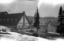
In Mount Rainier Park : Part of Paradise Inn
Part of William Orson Banfield fonds