
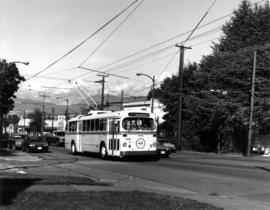
Dunbar and 41st, looking east on 41st
- AM1533-S2-4-: 2009-005.523
- Item
- ca. 1946
Part of Dunbar History Project fonds
Item filed under Transportation. Courtesy of Hodgson/Sharman Collection.
Dunbar and 41st, looking east on 41st
Part of Dunbar History Project fonds
Item filed under Transportation. Courtesy of Hodgson/Sharman Collection.

Dunbar streetcar on Dunbar at 41st Avenue
Part of Dunbar History Project fonds
Item filed under Transportation. Courtesy of Hodgson/Sharman Collection.

#25 King Edward St. bus, eastbound on King Edward at Dunbar
Part of Dunbar History Project fonds
Item filed under Transportation. Courtesy of Angus McIntyre.

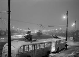
Brill trolley bus, southbound on Dunbar at 31st Avenue
Part of Dunbar History Project fonds
Item filed under Transportation. Courtesy of Angus McIntyre.
Alma Street, southbound at 11th Avenue
Part of Dunbar History Project fonds
Item filed under Transportation. Courtesy of Angus McIntyre.

Mass transit system, the interurbans

Map and Guide to Vancouver Street Car and Interurban Lines
Part of City of Vancouver Archives technical and cartographic drawing collection
Part is the front side of an informational pamphlet published by the BC Electric Railway Co. regarding City streetcar routes and interurban lines, golf and country clubs, city trips, interurban trips, motor coach trips, stations, ferries and docks, bathing beaches, public parks, North Shore canyons and parks, athletic and amusement parks.

Vancouver city and suburban lines
Part of City of Vancouver Archives technical and cartographic drawing collection
Part is the back side of an informational pamphlet published by the BC Electric Railway Co. showing street car lines, interurban lines, bus routes and parks.
O'Brien Advertising : non partisan city shots : housing, sewers etc.

O'Brien Advertising : 41st crosstown and Renfrew Heights

O'Brien Advertising : 41st crosstown and Renfrew Heights
![City Views from City Hall Roof [12 of 24]](/uploads/r/null/f/f/ff69edeeb7418181b4b9d33e095bc7cc21c9af4d0e2554b09c831d3bf1f7bd50/429f6a28-039f-489b-adf6-8ea31d84bd36-A67857_142.jpg)
City Views from City Hall Roof [12 of 24]
Part of City of Vancouver fonds
Photograph shows the construction of a section of the Expo Line SkyTrain Line, BC Place stadium is to the right. The downtown skyline looms to the North.
![City Views from City Hall Roof [13 of 24]](/uploads/r/null/4/7/4774b69977e18e03a3c35274aef841f93d72ba20e64820cb1c210e14abf26ad9/84d038bf-fdb0-4c4c-9e62-02a16105f1f9-A67858_142.jpg)
City Views from City Hall Roof [13 of 24]
Part of City of Vancouver fonds
Item is a photograph showing the construction of a section of the Expo Line SkyTrain with downtown Vancouver in the background.
![City Views from City Hall Roof [16 of 24]](/uploads/r/null/e/1/e1745fc8098274a622f9b7281ad57b9ee2a97b994c22c830e4b4d11c7c90dfdd/1584c896-2000-42e9-bd58-b8b31f531bb8-A67861_142.jpg)
City Views from City Hall Roof [16 of 24]
Part of City of Vancouver fonds
Photograph depicts the construction of a section of the Expo SkyTrain Line facing North with the Downtown skyline to the rear. BC Place stadium is to the right.
![City Views from City Hall Roof [17 of 24]](/uploads/r/null/8/8/88d3bef1c1469ce1cc10bc8fbca23f86c609be30d9831d61a4d50c1b4d64bdf2/81e29215-8eee-48b5-96b4-b0b43141da58-A67862_142.jpg)
City Views from City Hall Roof [17 of 24]
Part of City of Vancouver fonds
Photograph depicts the construction of a section of the Expo SkyTrain line.
![City Views from City Hall Roof [18 of 24]](/uploads/r/null/b/8/b8a7473b4694078665501a45fbb5222c49d42eead5c903c6be96a83aa3b99522/4ea08f7e-1727-4cc4-a055-b869b199d0c4-A67863_142.jpg)
City Views from City Hall Roof [18 of 24]
Part of City of Vancouver fonds
Item is a photograph showing the construction of a section of the Expo Line SkyTrain with downtown Vancouver in the background.
![City Views from City Hall Roof [19 of 24]](/uploads/r/null/c/a/ca3d15ba4d81c83975b97928f035237b4425c5a29a6684d52b04ed219a337cd7/a60eb6cc-80da-4e0c-910c-7f061c723c7d-A67864_142.jpg)
City Views from City Hall Roof [19 of 24]
Part of City of Vancouver fonds
Item is a photograph showing the construction of a section of the Expo Line SkyTrain Line with downtown Vancouver and mountains to the North in the background.
![City Views from City Hall Roof [20 of 24]](/uploads/r/null/7/8/784278dadc0ec6138ec4911aa512e24be1ec0e4cb73ac4fa98b1f5a6c163fc41/e12df3b0-0ee4-4c46-aad2-5cd2661c5c51-A67865_142.jpg)
City Views from City Hall Roof [20 of 24]
Part of City of Vancouver fonds
Photograph shows the construction of a section of the Expo SkyTrain line, facing North.
![City Views from City Hall Roof [21 of 24]](/uploads/r/null/c/3/c34c35e24ac2c8f5d5c6fc43cddb04257387480434c726ff893b7323ae867b79/2c7dee02-363e-4796-9faf-fe4b8543bee1-A67866_142.jpg)
City Views from City Hall Roof [21 of 24]
Part of City of Vancouver fonds
Photograph depicts the construction of the Expo SkyTrain line.
![City Views from City Hall Roof [22 of 24]](/uploads/r/null/7/4/74ac32645d3ea944dc95121c4dccd61f2ef4181a471addcbb60c3dc21f4bfeaa/0a04d3f4-ce9a-4ef5-9d43-e8d2107c0a68-A67867_142.jpg)
City Views from City Hall Roof [22 of 24]
Part of City of Vancouver fonds
Photograph shows the construction of a section of the Expo Line Skytrain system.
![City Views from City Hall Roof [23 of 24]](/uploads/r/null/f/2/f2dfbad8353ca656ed75e536e00db931ea2d9be45ede79635d7589ab692c853b/5dbdaa58-a8ca-4078-ace2-bd8a847c9728-A67868_142.jpg)
City Views from City Hall Roof [23 of 24]
Part of City of Vancouver fonds
Photograph depicts the construction of the Expo Line Skytrain track in readiness for the Expo 86 World Fair.
![City Views from City Hall Roof [24 of 24]](/uploads/r/null/4/4/444e12857bb80d1fedbb929794bcedc8571ab7a609a02ad6dd94081a07b0ea66/4205ef88-e1a9-4a5f-bcc2-66d0777cd10c-A67869_142.jpg)
City Views from City Hall Roof [24 of 24]
Part of City of Vancouver fonds
Photograph shows the construction of a section of the Expo Line SkyTrain system.

Map of City of Vancouver, British Columbia
Map shows streets, schools, hospitals, street car lines, railways and address block numbers in Vancouver.

Composite map of B.C. Electric downtown bus routes
Part shows bus routes from Burrard Inlet in the north to False Creek in the south and from Main Street in the east to Thurlow in the west.

Bus routings in the downtown area
Part contains textual information about bus routes and services.

Map of Fraser Valley ; Street map of New Westminster ; Map of Greater Vancouver transit lines
Part consists of a street map of the Lower Mainland and Fraser Valley from Vancouver to Chilliwack, a street map of New Westminster, a map showing transit lines in Greater Vancouver, and text advertising the products and services of the Dominion Map and Blueprint Company.

Transit system map of Greater Vancouver, B.C.
Part consists of a map showing trolley coach lines, bus lines, street car lines, interurban lines, interurban stops, route numbers, B.C. Electric installations and block numbers in West Vancouver, North Vancouver, Vancouver, Burnaby and the University Endowment Lands.

Transit detail inset maps ; Street index ; Transit and tourist information
Part consists of three maps showing transit details in Richmond, New Westminster and downtown Vancouver, and descriptive information about B.C. Electric routes and services and Greater Vancouver attractions.

What the man who comes to Vancouver wants to know
Part of City of Vancouver Archives technical and cartographic drawing collection
Part contains information on lodging, restaurants, transit, social clubs, and other points of interest in Vancouver.

Part of City of Vancouver Archives technical and cartographic drawing collection
Part contains a street map of Vancouver showing streets, block numbers, bus routes, railway lines, boundaries, private roads and hospitals. The map includes a dial (a numbered circle, a paper indicator, a grid of block numbers and a street index used to find locations in Vancouver). A small inset shows the streets surrounding Queen Elizabeth Park, which are obscured on the main map where the indicator is attached.

Map of Burnaby and New Westminster, British Columbia
Part of City of Vancouver Archives technical and cartographic drawing collection
Part consists of a street map of Burnaby and New Westminster, information on bus and street car routes, and text advertising the products and services of the Dominion Map and Blueprint Company.

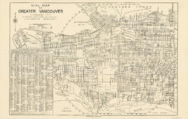
Dial map of Greater Vancouver and suburbs
Part of City of Vancouver Archives technical and cartographic drawing collection
Part contains a street map of Vancouver, Burnaby, New Westminster, West Vancouver and North Vancouver showing block numbers, street car, bus, and railway lines, parks and hospitals. Map includes two dials (a numbered circle, a paper indicator, a grid of block numbers and a street index used to find locations). A small inset map shows the Capitol Hill/Scenic Park area of Burnaby in greater detail.
Part contains a street map of Vancouver showing street car, bus and railway lines, hospitals, and block numbers. Part includes a dial (a numbered circle, a paper indicator, a grid of block numbers and a street index used to find locations).

Part contains a street map of Vancouver showing street car, bus and railway lines, hospitals, and block numbers. Part includes a dial (a numbered circle, a paper indicator, a grid of block numbers and a street index used to find locations).

Dial map of Greater Vancouver and suburbs
Part contains a street map of Vancouver, Burnaby, New Westminster, West Vancouver and North Vancouver showing block numbers, street car, bus, and railway lines, parks and hospitals. Map includes two dials (a numbered circle, a paper indicator, a grid of block numbers and a street index used to find locations). A small inset map shows the Capitol Hill/Scenic Park area of Burnaby in greater detail.

B.C. Electric Rly. Co. Ltd. plan showing transit services in Vancouver city as at end of 1951
Part of City of Vancouver Archives technical and cartographic drawing collection
Part is a map showing existing and proposed transit lines in Vancouver.
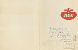
Part of City of Vancouver Archives technical and cartographic drawing collection
Part contains B.C. Electric logo and J.S. Matthews's annotations regarding the plan.

Guide map : Vancouver, New Westminster, Burnaby and North Shore municipalities
Part of City of Vancouver Archives technical and cartographic drawing collection
Part contains a map of Greater Vancouver showing city streets, schools, firehalls, parks and golf courses, railways, street railways and interurban lines, hospitals and bus routes.
![City of Vancouver surrounding [sic] and municipalities including City of New Westminster](/uploads/r/null/8/9/1/8919931915a624a5abd2e5d2953118fdd853654343ce31193f00d341d482bf39/fd6eb299-3e6a-498e-bfd9-62a3279a8861-LEG1329_142.jpg)
City of Vancouver surrounding [sic] and municipalities including City of New Westminster
Part of City of Vancouver Archives technical and cartographic drawing collection
Part contains a street map showing distances from a point in downtown Vancouver, waterfront businesses in Burrard Inlet, street car lines, bus lines, parks, golf courses, schools and hospitals.

British Columbia Electric Railway Company Limited : Vancouver Island system and Mainland system
Part of City of Vancouver Archives technical and cartographic drawing collection
Part contains two maps showing city, suburban, and interurban railway lines, transmission lines, generating stations, substations, and transformers.

Part of City of Vancouver Archives technical and cartographic drawing collection
Part contains a map showing street car, interurban, and motor bus lines in from Vancouver to New Westminster, a map showing existing and projected power plants near Alouette and Stave Lakes, and a profile showing the existing and proposed plants.

Transit system map of Greater Vancouver, B.C.
Part of City of Vancouver Archives technical and cartographic drawing collection
Part contains a map of Greater Vancouver showing bus lines, route numbers, B.C. Electric installations, block numbers, points of interest and amenities; an inset map showing streets in Gleneagles, Whytecliff, and Horseshoe Bay; and an inset map showing streets in Port Moody, Coquitlam, and Maillardville.

Part of City of Vancouver Archives technical and cartographic drawing collection
Part contains maps of the Richmond and downtown Vancouver transit systems, a street index to the Greater Vancouver map on the other side of the sheet, information on B.C. Electric transit routes, and general tourist information.

Bus routes, city of Vancouver, November 26th 1937
Part of City of Vancouver Archives technical and cartographic drawing collection

Page from "The Buzzer," November 26, 1937, showing map of bus routes
Part of City of Vancouver Archives technical and cartographic drawing collection
Part is the verso of a hand-drawn map showing bus routes in Vancouver, and contains a page from the November 26, 1937 edition of "The Buzzer." The page contains information on bus routes in Vancouver and a reproduction of the hand-drawn map.

Transit routes in downtown area Vancouver, B.C. effective July 18, 1952
Part of City of Vancouver Archives technical and cartographic drawing collection
Item is a sheet which contains maps of the downtown portions of 14 BC Electric transit routes: Dunbar, Arbutus, Granville - Kingsway - Victoria, Macdonald, 4th Ave. - West Pt. Grey, Powell - Stanley Park, Broadway East - Robson, Hastings East, Main, Davie - Fraser, Grandview, Oak, Cambie, North Vancouver - Intercity.