![Jericho #7 [1 of 34]](/uploads/r/null/c/a/8/ca83ff62461114d5291169f8a891ed84f91de2b6e17ca0e2a68bf04c3bf2a261/c560542c-abf2-4491-a4ff-6c62d5b1d272-CVA395-00210_142.jpg)
- AM1671-: CVA 395-00210
- Item
- [Oct. 31, 1975 or Nov.1, 1975]
Part of Habitat Forum photographs
Part of Habitat Forum photographs
![Jericho #7 [4 of 34]](/uploads/r/null/c/b/8/cb8f061c757db8a4b077216eccf890d48aa23fd23016a0db73be1fae215daedc/fc2ca480-2f3b-442d-b939-f2d8b310c3a6-CVA395-00213_142.jpg)
Part of Habitat Forum photographs
![Jericho #7 [15 of 34]](/uploads/r/null/f/7/5/f75439ebd077b7390e63735600be0e1242c82b9e755df14095caa21e7202e6e9/e74bb655-7879-4526-9828-3e6b7df00ac2-CVA395-00224_142.jpg)
Part of Habitat Forum photographs
![Jericho #7 [17 of 34]](/uploads/r/null/8/6/b/86be98455a305aa05e9d854ffc33575bf375a8935bab446ed2c75e5d0845fc8d/424dd6e2-0fd2-4b15-9914-e5c71ea274db-CVA395-00226_142.jpg)
Part of Habitat Forum photographs
![Jericho #7 [34 of 34]](/uploads/r/null/6/3/7/6370805a6eb5ca0c65f5a1b6339b939d27e32bd96fb7217f943d112e520dbdb1/f45f4615-ec58-457e-bdb1-1a386ad778b6-CVA395-00243_142.jpg)
Part of Habitat Forum photographs
![Jericho #7 [3 of 34]](/uploads/r/null/c/c/b/ccb4dd3bc87e701dd3f32fee73f449e9aa56a0f1d99ac6037ec03585175422ef/a3bbb9f7-f595-4be6-a322-bc4bc31edb7d-CVA395-00212_142.jpg)
Part of Habitat Forum photographs
![Jericho #7 [10 of 34]](/uploads/r/null/1/8/b/18bd959f8c45b9d468d31ee72aff16cbffb8588879731501ca11596cba981da3/57e5dee2-7d89-4cb3-8d5c-017408f08f8f-CVA395-00219_142.jpg)
Part of Habitat Forum photographs
![Jericho #7 [11 of 34]](/uploads/r/null/c/4/b/c4b3f780f22ea21802a00249c6f905b922db79261c2baa1565b9ede736b1aedc/6ed7fae6-b24f-4bbf-9e9d-d85201e4dbc6-CVA395-00220_142.jpg)
Part of Habitat Forum photographs
![Jericho #7 [12 of 34]](/uploads/r/null/6/f/4/6f4b250bc0b1a039c2fbeeb135fb7fe7b9a2dabe861274ccc97a4a6ccdd4bc9c/8b46eac3-e8de-471d-a193-f702b75f6575-CVA395-00221_142.jpg)
Part of Habitat Forum photographs
![Jericho #7 [18 of 34]](/uploads/r/null/6/a/3/6a3f90bfa7111a47d1660f8c2596016568c93011dab755ba8d72d2da60c44dce/333d52b9-266c-46de-8030-67ba280286b1-CVA395-00227_142.jpg)
Part of Habitat Forum photographs
![Jericho #7 [21 of 34]](/uploads/r/null/8/7/5/87530eb82917f0326545d6b26a73a224fe54a7842728965b1f10c6f74d613a1d/074f8b2a-68ad-4382-819a-222a6d0cf01b-CVA395-00230_142.jpg)
Part of Habitat Forum photographs
![Jericho #7 [22 of 34]](/uploads/r/null/f/9/8/f98030f62d9bd2466fb43be1da47f9e42f79c031d5e50c656eb9848e9790efe8/d9946ab4-72fa-4717-9083-c21834df61fc-CVA395-00231_142.jpg)
Part of Habitat Forum photographs
![Jericho #7 [24 of 34]](/uploads/r/null/b/8/9/b8919a0213d5ec2ed490153452d2ff476530b9fe1fd8027dc81ddb04e516529e/b8f167ac-03d4-4557-8049-471e78234ffb-CVA395-00233_142.jpg)
Part of Habitat Forum photographs
![Jericho #7 [25 of 34]](/uploads/r/null/2/4/8/248478cea95c4ed76e53495b6f71fdb8febecb52239d58385a72132ecedafb08/1a69fcd5-35af-43a4-9816-4293bd142630-CVA395-00234_142.jpg)
Part of Habitat Forum photographs
![Jericho #7 [27 of 34]](/uploads/r/null/8/8/3/88389679cf10cc8dd2fc18fa2bdeced20568757ff472ad6c3bcd146b1e3c739b/7b2d669d-2dcf-40ae-9da0-8113cd18d200-CVA395-00236_142.jpg)
Part of Habitat Forum photographs
![Jericho #7 [29 of 34]](/uploads/r/null/e/7/0/e70cb060d9b8365b81d0bffc47437f19d568aed9d5f9c8c4dc2620616726d0e0/d4b0effa-7ace-4ff8-ac24-b50316bbe30f-CVA395-00238_142.jpg)
Part of Habitat Forum photographs
![Jericho #7 [30 of 34]](/uploads/r/null/a/9/8/a982cb62e998c26b33717013f570649724a87787c9ad22fe0378851c522a5117/cf6ee8e2-2c38-4b39-8938-925c720932fc-CVA395-00239_142.jpg)
Part of Habitat Forum photographs
![Jericho #7 [33 of 34]](/uploads/r/null/b/8/8/b881bba073c25b8568c1d71e626e373d630394bf079bd297980fb744853399a5/080e65c4-b31c-49b2-b323-f69310d52f50-CVA395-00242_142.jpg)
Part of Habitat Forum photographs
![Jericho #7 [2 of 34]](/uploads/r/null/3/1/1/311ec3b2df7806b25dbec73a139ff989b00ac10f324fc1a6fe176341c5e80305/6fed8959-08db-4549-a0b0-852f4cfd2d9b-CVA395-00211_142.jpg)
Part of Habitat Forum photographs
![Jericho #7 [5 of 34]](/uploads/r/null/f/f/d/ffd738405f062f309de41bb11d8b412a7dcf62f7181c7311ccd8deee59c92124/cd8ada54-e2a1-416b-98e9-2c9fd5facb5b-CVA395-00214_142.jpg)
Part of Habitat Forum photographs
![Jericho #7 [8 of 34]](/uploads/r/null/f/3/9/f39662d2db057b3c84331004fdd38ba62f6630e880c44359393f860cacfc7fe0/8d250e95-c3ef-4437-add8-d4f8486e4934-CVA395-00217_142.jpg)
Part of Habitat Forum photographs
![Jericho #7 [13 of 34]](/uploads/r/null/a/a/d/aadb5f0973ccbe57e57b585b8dcfcc2c05147598666f58fced4bfbd28fa4e864/9775809b-9a28-4e21-8d00-ed00446d873a-CVA395-00222_142.jpg)
Part of Habitat Forum photographs
![Jericho #7 [19 of 34]](/uploads/r/null/0/c/c/0ccde30e71b5279f2792b01ecee09be20befc6a5fb445370cb74f0127910b247/11ab165b-0235-4d9b-8cf8-065fc04e67c3-CVA395-00228_142.jpg)
Part of Habitat Forum photographs
![Jericho #7 [20 of 34]](/uploads/r/null/c/d/0/cd094c8646b386a0a040630fa9c02d80d4fc2620373018d73240f516dd3460f2/7411b5ee-8d5a-43f8-acd8-cdf097814a00-CVA395-00229_142.jpg)
Part of Habitat Forum photographs
![Jericho #7 [28 of 34]](/uploads/r/null/a/5/8/a58661eb0eb58ba13f358cb74e0a0707dba71faf770da795abc14d4242058b56/1db42ffb-d26b-4f9e-897c-6cfb298926a3-CVA395-00237_142.jpg)
Part of Habitat Forum photographs
![Jericho #7 [6 of 34]](/uploads/r/null/3/b/d/3bd242ef6484670d3b118519a3f99d65464df88ad44bb0e7835d988083b1337d/e45fc92a-0759-4232-b507-94088b32e3c9-CVA395-00215_142.jpg)
Part of Habitat Forum photographs
![Jericho #7 [7 of 34]](/uploads/r/null/b/5/e/b5ed2a70990d2d08ccdf535e971a7b0b8cf4d58538e8efd03ffac21013cbb101/f9de0cb5-86b9-4552-af7f-3f6092d710bb-CVA395-00216_142.jpg)
Part of Habitat Forum photographs
![Jericho #7 [9 of 34]](/uploads/r/null/1/5/9/159e7de7aa10a7703841c8ee9a8ffaa2ed1e2281c110e43105b8d9903e3a0eba/fb5875c0-7d29-4f33-a48e-cbec0ca257ff-CVA395-00218_142.jpg)
Part of Habitat Forum photographs
![Jericho #7 [14 of 34]](/uploads/r/null/6/9/4/694b9d2044bd5d02626d372f883f16d1179ca7207e5fc938fbdc51c25b82aa42/2484de64-8b30-4e64-b2cf-d04947b061f1-CVA395-00223_142.jpg)
Part of Habitat Forum photographs
![Jericho #7 [16 of 34]](/uploads/r/null/1/a/5/1a58f208318605a20206508610b9ded54e834d38b4e241a1d9895880362b29b9/0c61fec0-8e57-42b3-b50b-d40f1784df79-CVA395-00225_142.jpg)
Part of Habitat Forum photographs
![Jericho #7 [23 of 34]](/uploads/r/null/6/3/d/63d211666831adf306e274c02f8e96527a9b59d63b5bfb3eae19056b0cf31f0e/c9c0daf0-05bf-409a-a96a-4366d13f5bf0-CVA395-00232_142.jpg)
Part of Habitat Forum photographs
![Jericho #7 [26 of 34]](/uploads/r/null/7/c/9/7c95572a5c824e5b49eb64a6341d5599b90b8b667658bca618b1c11eb58668de/2b2facef-4efe-496e-ba45-fad9602cf98b-CVA395-00235_142.jpg)
Part of Habitat Forum photographs
![Jericho #7 [31 of 34]](/uploads/r/null/f/c/5/fc56bc9c3dfe24ec489474581cb79ed64f723931cac3faffa54a67fa0fb27a5c/75b4dad8-9735-41a7-bf2d-b01f08bb1f76-CVA395-00240_142.jpg)
Part of Habitat Forum photographs
![Jericho #7 [32 of 34]](/uploads/r/null/6/8/f/68f385d1ab71eb18d4ce8fcf6f1b5e6d1c31096a4dd1ecef11855830fc053c36/9410c60d-8505-47c3-913f-13b9fe2a7cf6-CVA395-00241_142.jpg)
Part of Habitat Forum photographs

Map of the town of Coevorden (portion)
Part of Adrien Mansvelt collection
Item is a reproduction of part of a map showing the location of the town of Coervorden, Netherlands and surrounding area.
van Deventer, Jacob

Zelfportret by Isaac Claesz van Swanenburg
Item is a photographic reproduction of Zelfportret by Isaac Claesz van Swanenburg.

Sicilian mill ca. 1600, the Mansell Collection

A portion of a map showing the coasts of Peru and Chile
Part of City of Vancouver Archives technical and cartographic drawing collection
Item is a photographic reproduction of a portion of a map of the Americas, depicting the Pacific coasts of South America.

Nova totius terrarum orbis geographica ac hydrographica tabula
Part of City of Vancouver Archives technical and cartographic drawing collection
Item is a reproduction of a geographical and hydrographical map of the world created in 1621.

Nova totius Americae descriptio
Part of City of Vancouver Archives technical and cartographic drawing collection
Item is a reproduction of a map depicting North America, Central America and South America.
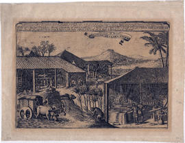
Sucreries du Bresil. Brasilise suyker werken
Item consists of a seventeenth century engraving of a sugar plantation in Brazil, including notes on various growing, harvesting and refining activities depicted.

Water powered cane mill, West Indies

A new map of the terraqueous globe
Part of City of Vancouver Archives technical and cartographic drawing collection
Item is a world map depicting the rough outlines of continents, rivers and other geographical features. The map is bordered with inset drawings and include the following dedication: "Dedicated to his Highness, William Duke of Gloucester".
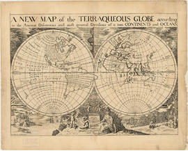
Part of City of Vancouver Archives technical and cartographic drawing collection
Item is a reproduction of a map depicting North American and South America.
Part of City of Vancouver Archives technical and cartographic drawing collection
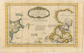
Item is a map engraved by French cartographer M. Bellin showing eastern Asia and the northern part of North America, mainly Canada. Includes notes as to areas of the west coast of North America explored by the Russians in 1728 and 1741, the exploration of the entrance of the Strait of Juan de Fuca in 1592 and 1603, as well as exploration on the east coast of Asia. Map also includes latitudes and longitudes, some place names, major bodies of water and indicates mountainous regions. Printed on the bottom of the map is "Tome XV" and "No. 4."


The asiatic part of the Russian empire
Part of City of Vancouver Archives technical and cartographic drawing collection
Item is a map sheet which appears to be a part of a map of Russia. The sheet depicts the area immediately around Lake Baikal, to the north coast and east to the Pacific, including the islands of the north-west Pacific.

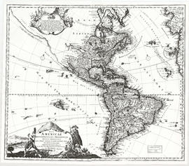
A map of the whole continent of America divided into North and South and West Indies
Part of City of Vancouver Archives technical and cartographic drawing collection
Item is a reproduction of a map which depicts North America, South America and the West Indies. An inset map on the lower left-hand corner shows Baffin Island and Hudson's Bay. The item also includes lists of islands and regions in the Americas belonging to each of Great Britain, France, Spain, Portugal, Denmark and the Dutch, as per the terms of the Treaty of Paris. The item also includes a list of nine relevant articles defined in the 1763 Paris treaty.