![[View of] Seven Sisters [trees in] Stanley Park](/uploads/r/null/d/2/d2754330cf448793c3c073dcd2f33b03d7cee764c89740c5286de269d78718a0/7eb439e6-155c-4690-a834-acab08124f61-A71872_142.jpg)
[View of] Seven Sisters [trees in] Stanley Park
- AM1663-: CVA 300-4
- Item
- [between 1936 and 1938]
Part of Karl Haspel fonds
44 results with digital objects Show results with digital objects
[View of] Seven Sisters [trees in] Stanley Park
Part of Karl Haspel fonds
Part of Karl Haspel fonds
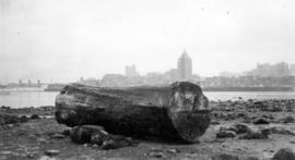
View of downtown Vancouver from Stanley Park
Part of Karl Haspel fonds

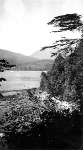
View of Stanley Park from the shore of Stanley Park
Part of Karl Haspel fonds

Part of Karl Haspel fonds

View of two ships from Brockton Point
Part of Karl Haspel fonds

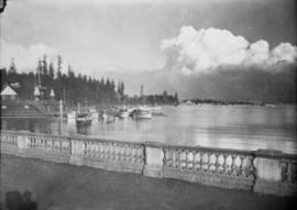
View from the railing of Brockton Point
Part of Karl Haspel fonds

View of Vancouver from the North Shore in a constructed panorama
Part of Karl Haspel fonds

Looking across First Narrows to Stanley Park at sunset
Part of Karl Haspel fonds
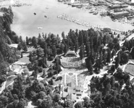
Aerial view of Malkin Bowl, Stanley Park and waterfront industries

Aerial view of Malkin Bowl, Stanley Park and waterfront industries

View of sunbathers on Second Beach

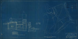
![Plan (in red) showing a suggested bye-pass [sic] road at south end of bridge to avoid cars making...](/uploads/r/null/5/f/a/5fa882ee3603828c85df983159b220e0d7d55438efe1ba4b847e4f6dff6a97f1/dae4a3ae-0095-4c04-bb66-221ef23eeafd-LEG1364_142.jpg)
Item is a map of the Prospect Point area annotated to show a suggested bypass road at the south end of the First Narrows Bridge. Base map shows roadways approaching the proposed First Narrows Bridge, locations of hydrants, topography, and details of landscaping in some areas, and includes two elevations of a proposed skew bridge.

Six-inch gun crew, 1914, Stanley Park, Vancouver
Item is a group photograph of the six-inch gun crew detachment (guns manned by R.C.N.V.R. personnel) in Stanley Park. [One identified individual in the photograph is Sam Collins, fifth from right.]

First Narrows. Proposed Suspension Bridge for Foot Passengers Only
Part of City of Vancouver Archives technical and cartographic drawing collection
Item consists of an architectural drawing for a proposed footbridge over the First Narrows, with its southern end near Prospect Point. The drawing consists of a plan and elevation of the structure. The sheet also includes a location map showing the span of the bridge in the context of Stanley Park and the North Vancouver shoreline.
Plan for Warren Harding memorial
Item is a blueprint copy of an architectural drawing showing a cross section and site plan for the memorial to the deceased U.S. President Warren G. Harding in Stanley Park. It has been annotated and signed in the top right corner in ink. It is numbered "Sheet 1".
![[View of] Vancouver from Brockton Point](/uploads/r/null/7/5/7541ae900ded7c1354aec796ca42339f66a10a6a9e23423ec2705156a6dc8bb4/7a5739e2-f1cc-4727-a466-e88b5cd52357-A71873_142.jpg)
[View of] Vancouver from Brockton Point
Part of Karl Haspel fonds
![[View of] Siwash Rock](/uploads/r/null/c/9/c9224cfee5702609fb0e3c83fffc91f0c2b889397f1496ec4b1e40b9294edffd/7ad7a98b-6b57-487b-a004-5ad3326b998a-A71871_142.jpg)
Part of Karl Haspel fonds
![Totems [in] Stanley Park](/uploads/r/null/8/7/87df2fe7090617db5d32d35ffdef84bf62e19e2e1f7f53e4a8005bb7159e601c/3e797735-4cc0-4300-84d6-58bd1a59d51a-A71870_142.jpg)
Part of Karl Haspel fonds

Part of Karl Haspel fonds

View of Siwash Rock with sailboat and tankers in the distance
Part of Karl Haspel fonds

Part of Karl Haspel fonds

View from the railing at Brockton Point
Part of Karl Haspel fonds
![[Stanley Park entrance bridge]](/uploads/r/null/5/c/5ce399cd2b7d37bc22d2c98462018eff318972d8fd649afb450ce6ae0180122f/1d8bc933-c2e3-4899-8bca-42f02d61e251-A01967_142.jpg)
[Stanley Park entrance bridge]

Siwash Rock, when the tree was alive!

Part of Karl Haspel fonds
![[Outdoor pool at Lumberman's Arch]](/uploads/r/null/d/8/f/d8f7ecde6434f828e01733b1959c15bbcf3b50424e9580eceb12b3cdf8b2975e/c8a5993f-5df0-4469-a566-a70221f00d9e-CVA1415-388_142.jpg)
[Outdoor pool at Lumberman's Arch]
Part of Arthur Collier fonds
Part of City publications collection
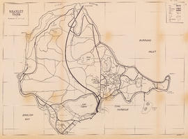
Item is a map showing roads, trails, walkways, parking lots, buildings, shorelines, creeks, and swamps in Stanley Park.
![Ceperley [playground] subway](/uploads/r/null/8/5/0/850e84daaf9413036ae0e954e5dbb992fb44e7175576161a9c9ca4c7bc128625/11a308de-c75d-46d0-af89-f1cfb4d02fbc-LEG1969_142.jpg)
Item is an architectural drawing depicting the design of the road underpass and Stanley Park Drive bridge adjacent to the Ceperley Park playground in Stanley Park. The drawing depicts plans, sections, a rendering of the bridge and a materials schedule.
Vancouver Park Board
![[Fun Run finish line at beach concession stand]](/uploads/r/null/4/c/4c47b9d8a2b775d1397860b90ac0fe034c1412521a2af4b4f86eb98c657bedbb/6d3ce949-5c3a-4514-8c55-ca0a07574e6a-A69722_142.jpg)
[Fun Run finish line at beach concession stand]
![[Fun Run runners queue, runners, and spectators]](/uploads/r/null/e/0/e00f0b2f8bc0178b4c978c0d98d99653afd8679d67fb6902c2150e2c2c96f33a/32cd8daa-d6dd-4fcb-9574-538412765e2c-A69721_142.jpg)
[Fun Run runners queue, runners, and spectators]
![[Fun Run runners queue]](/uploads/r/null/9/2/920b9ad9010bd9008f5b4f452cb12cc923a821ee898544f84a94eecb89356c27/e563bcaf-353c-4da5-9b22-5116f4e61694-A69720_142.jpg)
![[Fun Run spectators, finish line, timer, and Labatt's trailer]](/uploads/r/null/2/7/27b5d4d8d5f16d6346c95b25b809895a958efa1a1a0b043b10becfe2b702ff30/9b8bb2a3-36a3-41be-a701-f79fdc5cea12-A69719_142.jpg)
[Fun Run spectators, finish line, timer, and Labatt's trailer]
![[Fun Run runners and spectators]](/uploads/r/null/2/5/25eb56f24fbfdf54964ddb004d5c3a802218572e2f2249a0a456fea91a8fce05/b8d5293e-a7bb-4555-8c35-00c286b7fe9f-A69718_142.jpg)
[Fun Run runners and spectators]
![[Fun Run runners and spectators]](/uploads/r/null/7/8/78d1350d491b960a5cb1e86b1f3423d11835192283dc4424f4c864d74fa15886/6425b11a-d556-43ec-95d9-dad3ed2d1632-A69717_142.jpg)
[Fun Run runners and spectators]
![[Fun Run starting line]](/uploads/r/null/e/6/e651512a66edb247501ed66610ce174c93e5c7612ec2fb30214686467f5f1c03/a6805018-df6e-4eb2-be5e-6cf38ec9c36b-A69716_142.jpg)
![[Man and group of children with left arms raised]](/uploads/r/null/f/1/f1db7164daf145aa4628cf326922bda39e882ab226ba008cd75a1ecc33b7ef15/36a7ed24-244a-4760-961c-166b21853379-A69999_142.jpg)
[Man and group of children with left arms raised]
![[Children and police officer beside traffic school race track]](/uploads/r/null/9/6/963576e3122d3d2cd536d1ed72cb2bac3cf23e6aa6a6d3b49eab37d824008d59/609d312a-bad8-4297-bafa-59c526818060-A70001_142.jpg)
[Children and police officer beside traffic school race track]
![[Children in cars on traffic school race track]](/uploads/r/null/a/3/a3a264bbf1af902016f63d0ee9f152a9c0583b6eae1f6b39213fe153ec071766/bca91304-c6bc-4791-ad56-a96b8a196a55-A70002_142.jpg)
[Children in cars on traffic school race track]
Part of City of Vancouver fonds
![[Children watching children drive small cars at traffic school]](/uploads/r/null/0/5/05f3d7e2d8510392ae505088bb2acd8b19128d61e507e8430eab9f08475cc3f3/41df757d-347d-4229-8016-0e0cbc489fef-A70000_142.jpg)
[Children watching children drive small cars at traffic school]
![[Sign for playground traffic school]](/uploads/r/null/3/5/358106df28680d8d2e8b51ad0e5cee002499b293f0d079e078d58ade2c45fc97/11a52189-e97a-482f-8411-b16edc2c4d00-A70003_142.jpg)
[Sign for playground traffic school]