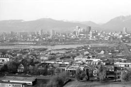
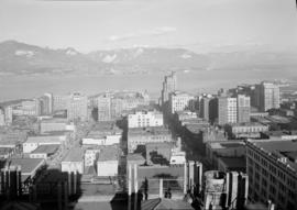
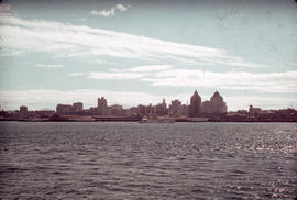
![Aerial of Vancouver [looking across False Creek to downtown]](/uploads/r/null/4/a/f/4afc9e796fba938d8c20f811a6931cd1465924c5f88c79fe4b20a0917bc57573/54f347ac-0258-4ebf-9162-a8b64c1f6af9-CVA306-16_142.jpg)
Aerial of Vancouver [looking across False Creek to downtown]
- AM633-S4-: CVA 306-16
- Item
- [ca. 1970]
Part of Greater Vancouver Visitors and Convention Bureau fonds
59 results with digital objects Show results with digital objects
Aerial of Vancouver [looking across False Creek to downtown]
Part of Greater Vancouver Visitors and Convention Bureau fonds

Aerial view of Burrard Street and surrounding area
Part of City of Vancouver fonds
![Conference Hangar #3 doctors [12 of 32]](/uploads/r/null/f/3/f/f3f42dd8dfc9375daeafa65b06c8a9abe09bd59ba7588ab49ca3c431dd16a8ec/97c63cca-8a69-43ef-8d24-633a04ecf233-2011-130_142.jpg)
Conference Hangar #3 doctors [12 of 32]
Part of Habitat Forum photographs
Item is a photograph showing a view of downtown from the water.

Downtown buildings at night from Hallelujah Point
![[Downtown buildings at night] from Hallelujah Point](/uploads/r/null/a/5/6/a5671e90548f3d81dee3269383829a7559227501f3e12753a6a028a2bc2d6733/47a986b9-7978-4f1c-90da-dc6f3a85037a-CVA293-025_142.jpg)
[Downtown buildings at night] from Hallelujah Point

Downtown buildings at night from Hallelujah Point
![[Downtown buildings at night] from Hallelujah Point](/uploads/r/null/3/c/7/3c7720e60b0972d26fdc2539afea5c9c49e27f085295d8d8f8600ab64f00c366/33acfefe-c307-490c-9031-cbc998039f83-CVA293-025_142.jpg)
[Downtown buildings at night] from Hallelujah Point

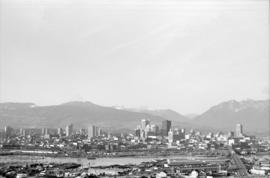
Downtown cityscape over Fairview and False Creek
Part of City of Vancouver fonds
Item part is a photograph of downtown Vancouver over Fairview and False Creek. The Granville Street Bridge and the Burrard Street Bridge are visible at the far left.

Downtown cityscape over Fairview, and False Creek
Part of City of Vancouver fonds

Downtown cityscape over Fairview, and False Creek
Part of City of Vancouver fonds

Downtown cityscape over Mount Pleasant and False Creek
Part of City of Vancouver fonds

Downtown cityscape over Mount Pleasant, Fairview, and False Creek
Part of City of Vancouver fonds
Item part is a photograph of downtown Vancouver, including a view down Cambie Street across the Cambie Street Bridge, and adjacent neighborhoods in Fairview and Mount Pleasant.

Downtown cityscape over Mount Pleasant, Fairview, and False Creek
Part of City of Vancouver fonds
Item part is a photograph of downtown Vancouver, including a view down Cambie Street across the Cambie Street Bridge, and adjacent neighborhoods in Fairview and Mount Pleasant.

Downtown cityscape over Mount Pleasant, Fairview, and False Creek
Part of City of Vancouver fonds
Item part is a photograph of downtown Vancouver, including a view down Cambie Street across the Cambie Street Bridge, and adjacent neighborhoods in Fairview and Mount Pleasant.
Downtown cityscape over Mount Pleasant, Fairview, and False Creek
Part of City of Vancouver fonds
Item part is a photograph of downtown Vancouver, including a view down Cambie Street across the Cambie Street Bridge, and adjacent neighborhoods in Fairview and Mount Pleasant.

Downtown cityscape over Mount Pleasant, Fairview, and False Creek
Part of City of Vancouver fonds
Item part is a photograph of downtown Vancouver, including a view down Cambie Street across the Cambie Street Bridge, and adjacent neighborhoods in Fairview and Mount Pleasant. The Granville Street Bridge and the Burrard Street Bridge are visible at the far left.

Downtown cityscape over Mount Pleasant, Fairview, and False Creek
Part of City of Vancouver fonds
Item part is a photograph of downtown Vancouver, including a view down Cambie Street across the Cambie Street Bridge, and adjacent neighborhoods in Fairview and Mount Pleasant.

Downtown cityscape over Mount Pleasant, Fairview, and False Creek
Part of City of Vancouver fonds
Item part is a photograph of downtown Vancouver, including a view down Cambie Street across the Cambie Street Bridge, and adjacent neighborhoods in Fairview and Mount Pleasant.

Downtown cityscape over Mount Pleasant, Fairview, and False Creek
Part of City of Vancouver fonds
Item part is a photograph of downtown Vancouver, including a view down Cambie Street across the Cambie Street Bridge, and adjacent neighborhoods in Fairview and Mount Pleasant.

Downtown cityscape over Mount Pleasant, Fairview, and False Creek
Part of City of Vancouver fonds
Item part is a photograph of downtown Vancouver, including a view down Cambie Street across the Cambie Street Bridge, and adjacent neighborhoods in Fairview and Mount Pleasant. The Granville Street Bridge and the Burrard Street Bridge are visible at the far left.
Downtown cityscape over Mount Pleasant, Fairview, and False Creek
Part of City of Vancouver fonds
Item part is a photograph of downtown Vancouver, including a view down Cambie Street across the Cambie Street Bridge, and adjacent neighborhoods in Fairview and Mount Pleasant.

Downtown cityscape over Mount Pleasant, Fairview, and False Creek
Part of City of Vancouver fonds
Item part is a photograph of downtown Vancouver, including a view down Cambie Street across the Cambie Street Bridge, and adjacent neighborhoods in Fairview and Mount Pleasant. The Granville Street Bridge and the Burrard Street Bridge are visible at the far left.

Downtown cityscape over Mount Pleasant, Fairview, and False Creek
Part of City of Vancouver fonds
Item part is a photograph of downtown Vancouver, including a view down Cambie Street across the Cambie Street Bridge, and adjacent neighborhoods in Fairview and Mount Pleasant.

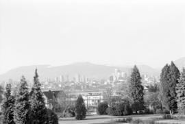
Downtown view over Fairview neighborhood
Part of City of Vancouver fonds
Item part is a photograph of the top of the downtown Vancouver skyline over the trees of a Fairview neighborhood. This photograph was taken from one of the lower floors of the Plaza 500 Hotel & Convention Centre.
Downtown view over Fairview neighborhood
Part of City of Vancouver fonds
Item part is a photograph of the top of the downtown Vancouver skyline over the trees of a Fairview neighborhood. This photograph was taken from one of the lower floors of the Plaza 500 Hotel & Convention Centre.

Downtown view over Fairview neighborhood
Part of City of Vancouver fonds
Item part is a photograph of the top of the downtown Vancouver skyline over the trees of a Fairview neighborhood. This photograph was taken from one of the lower floors of the Plaza 500 Hotel & Convention Centre.
![Fairyland, B.C. [View of the West End and downtown Vancouver taken at night from Jericho Beach.]](/uploads/r/null/a/8/e/a8e3a495f59bcd444d67c1f58f4e6637f2b485e6b359321dfad9189cbbe72abe/4aa2b5c6-07eb-41a9-8034-9911274f8595-CVA293-008_142.jpg)
Fairyland, B.C. [View of the West End and downtown Vancouver taken at night from Jericho Beach.]
![Fairyland, B.C. [View of the West End and downtown Vancouver taken at night from Jericho Beach.]](/uploads/r/null/d/f/a/dfac1737c680e690f5df79ec74560374b99585d3e61e6432c9ee22069f7f6da3/399457d4-0f6d-4823-929a-1cde999e64c6-CVA293-008_142.jpg)
Fairyland, B.C. [View of the West End and downtown Vancouver taken at night from Jericho Beach.]

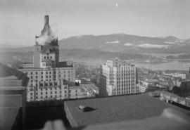
T. Eaton Co. : panorama shots of city and skyline from top of old Hotel Vancouver
T. Eaton Co. : panorama shots of city and skyline from top of old Hotel Vancouver
T. Eaton Co. : panorama shots of city and skyline from top of old Hotel Vancouver

T. Eaton Co. : panorama shots of city and skyline from top of old Hotel Vancouver

T. Eaton Co. : panorama shots of city and skyline from top of old Hotel Vancouver
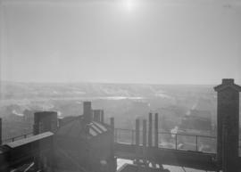
T. Eaton Co. : panorama shots of city and skyline from top of old Hotel Vancouver

T. Eaton Co. : panorama shots of city and skyline from top of old Hotel Vancouver

T. Eaton Co. : panorama shots of city and skyline from top of old Hotel Vancouver
T. Eaton Co. : panorama shots of city and skyline from top of old Hotel Vancouver

Part of Greater Vancouver Visitors and Convention Bureau fonds

Part of George Thompson fonds

Vancouver skyline from Coal Harbour
Part of City of Vancouver fonds

Vancouver skyline from Coal Harbour
Part of City of Vancouver fonds

Vancouver skyline from Coal Harbour
Part of City of Vancouver fonds
Vancouver skyline from Coal Harbour
Part of City of Vancouver fonds

Vancouver skyline from Coal Harbour
Part of City of Vancouver fonds

Vancouver skyline from Coal Harbour
Part of City of Vancouver fonds
![Vancouver, B.C. [View of downtown (Ailsa Lodge), Coal Harbour and Stanley Park]](/uploads/r/null/6/3/9/639be563fcca94701436caa27c2e67f7d7fea5ac6d8bd3edd5806930da05dddc/d0bd6cfd-b64c-4d4e-a785-4716ad3db5af-CVA298-004_142.jpg)
Vancouver, B.C. [View of downtown (Ailsa Lodge), Coal Harbour and Stanley Park]
Part of George Thompson fonds

Vancouver, B.C., Canada : the English Bay skyline at night
Item is a postcard printed with an image of the English Bay skyline at night. Caption on back of postcard: "The English Bay skyline at night is an impressive sight as the multi colored lights reflect on the waters. The row of chairlift lights on Grouse Mountain are visible for miles on clear evenings."

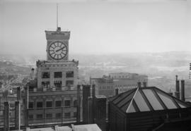
View from roof garden, Hotel Vancouver
Part of Bertram Emery fonds

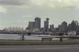
View of Canada Place and Downtown Vancouver
Part of City of Vancouver fonds
View of downtown from Burrard Inlet
Part of Leopold Bentley family fonds