British Columbia - Vancouver skyline
- AM1435-: CVA 1435-13
- Item
- [197-?]
Item is aerial photograph showing part of downtown Vancouver looking north towards Stanley Park and Coal Harbour.
British Columbia - Vancouver skyline
Item is aerial photograph showing part of downtown Vancouver looking north towards Stanley Park and Coal Harbour.

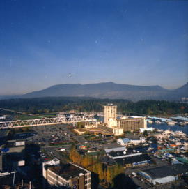
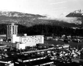
British Columbia - Vancouver skyline
Item is aerial photograph showing downtown Vancouver and Burrard Inlet.

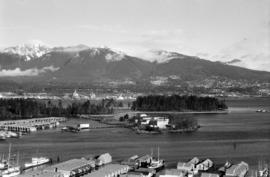
British Columbia - Vancouver skyline
Item is aerial photograph showing Coal Harbour and Burrard Inlet

British Columbia - Vancouver skyline
Item is aerial photograph of Coal Harbour and Burrard Inlet.

British Columbia - Vancouver skyline
Item is photograph showing Coal Harbour and Stanley Park.

British Columbia - Vancouver skyline
Item is photograph showing Stanley Park and Coal Harbour.

British Columbia - Vancouver skyline
Item is photograph showing Coal Harbour and Stanley Park.
British Columbia - Vancouver skyline
Item is photograph showing view of Coal Harbour and Stanley Park taken from Westcoast building.

British Columbia - Vancouver skyline
Item is photograph showing an aerial view of Burrard Inlet showing the southern shoreline and parts of Stanley Park.

British Columbia - Vancouver skyline
Item is aerial photograph showing Coal Harbour from the south shore.

British Columbia - Vancouver skyline
Item is aerial photograph showing Coal Harbour from the south shore.

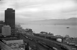
British Columbia - Vancouver skyline
Item is photograph showing downtown Vancouver looking north west towards Stanley Park and Coal Harbour.
British Columbia - Vancouver skyline : new office bldg. Vancouver
Item is photograph showing Coal Harbour and Stanley Park.

British Columbia - Vancouver skyline
Item is photograph showing Burrard Inlet, Coal Harbour, and Stanley Park.

British Columbia - Vancouver skyline
Item is photograph showing Coal Harbour and Stanley Park.

British Columbia - Vancouver skyline
Item is photograph showing Coal Harbour and Stanley Park.

British Columbia - Vancouver skyline
Item is aerial photograph showing downtown Vancouver looking north west towards Stanley Park and Coal Harbour.

British Columbia - Vancouver skyline
Item is aerial photograph showing Burrard Inlet and Coal Harbour.

British Columbia - Vancouver skyline
Item is photograph showing Coal Harbour and Stanley Park.
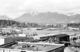
British Columbia - Vancouver skyline
Item is aerial photograph showing Coal Harbour and Stanley Park.

British Columbia - Vancouver skyline
Item is photograph showing downtown Vancouver looking north west towards Coal Harbour and Stanley Park.
British Columbia - Vancouver skyline
Item is photograph showing downtown Vancouver looking north west towards Coal Harbour and Stanley Park.
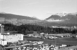
British Columbia - Vancouver skyline
Item is aerial photograph showing Stanley Park and Coal Harbour.

British Columbia - Vancouver skyline
Item is photograph showing Coal Harbour and Burrard Inlet

Bowen Lodge viewed from harbour
Part of Stuart Thomson fonds
![[Bowen Lodge viewed from harbour]](/uploads/r/null/f/4/f4870e098d1b1bb9ef2544df5c113bed17824caf3a0ccb4736743bec67d65a04/3c930c6c-3285-43d7-95ac-67ed6c69d07e-A16128_142.jpg)
[Bowen Lodge viewed from harbour]
Part of Stuart Thomson fonds
![[Boats in] Coal Harbour](/uploads/r/null/4/e/4e0ce74158796911dcd444ae208a0139e91a4251c536cf44042cbf4336ab4be4/9190958d-05ac-45a7-ae92-6df410a7bab9-A01926_142.jpg)
Photograph shows various types of boats in the harbour, with Stanley Park in the background.
![[Boats at anchor in island harbour]](/uploads/r/null/2/6/262e645a55bba35432f103ba74274d794b9e4719d5af2c4da74ef4ab47a0a480/f751b479-05ba-4cb3-86fb-412bd9ad655c-A16054_142.jpg)
[Boats at anchor in island harbour]
Part of Stuart Thomson fonds

Bird's Eye View - Vancouver Harbour B.C. Proposed Kitsilano Terminal and Free Port
Item is a mounted photographic copy of an aerial oblique perspective drawing of a proposed terminal and port facility located, but never built, at Kitsilano Point, Vancouver, B.C.
![[Avalon Harbour, Santa Catalina Island]](/uploads/r/null/2/0/201dc77a13151a5d79ca8d3bfa600a2175e89020ccfe2aed1e606a13daa8809e/1659f6ee-249a-4d46-9ac2-2fccf1a8a479-CVA1477-520_142.jpg)
[Avalon Harbour, Santa Catalina Island]
Part of L.D. Taylor family fonds
![[Avalon Harbour, Santa Catalina Island]](/uploads/r/null/f/2/f2184506a11e81a253d0060d8a571b077563283a65c7586fa8bcb09b39d573ba/505f7ee2-5ec3-4df1-99a1-32c291678ae4-CVA1477-519_142.jpg)
[Avalon Harbour, Santa Catalina Island]
Part of L.D. Taylor family fonds
![Australian Cruiser New Zealand [HMS New Zealand]](/uploads/r/null/4/7/47f1ff409d6ea3b747698613fdd117f202fdf19eadad50ca1a784f48b12bf276/8ea6ae46-954d-4da1-9a45-b9af0017adba-A49469_142.jpg)
Australian Cruiser New Zealand [HMS New Zealand]
Part of H.A. Price collection
Photograph shows HMS New Zealand anchored in Vancouver Harbour. A gift from the people of New Zealand to the Imperial Government, HMS New Zealand was on a ten month tour of the Dominions before joining the Grand Fleet.

Part of Hubert William Lovell fonds
Photograph was taken in the summer.
![Anchorage [4 large ships anchored in harbour]](/uploads/r/null/7/2/1/72172dde853b999550f9706c094e552f217cbfb2dfee81def2e803b58e216eb5/5e45b343-7a82-4860-b0fe-8c2e79f96eec-CVA293-102_142.jpg)
Anchorage [4 large ships anchored in harbour]
![Anchorage [4 large ships anchored in harbour]](/uploads/r/null/b/1/7/b17afd6d1a0943c297e40d302881bdf64981911420bd54c8a8c8d5f2e9cf5143/ae1459eb-8f9a-4300-b7c0-693ace510103-CVA293-102_142.jpg)
Anchorage [4 large ships anchored in harbour]

Part of Stuart Thomson fonds

Part of Stuart Thomson fonds
![[Aerial view of Vancouver Harbour looking east from Lost Lagoon]](/uploads/r/null/a/7/a7c598133f7f2c78a6bb65602262bc193ceb787389db5cd31ded3868025265ca/72eb674f-7c20-4ecc-a618-3a1e88e660c8-A62798_142.jpg)
[Aerial view of Vancouver Harbour looking east from Lost Lagoon]
Part of Major Matthews collection
Oblique view showing Coal Harbour, Deadman's Island, Denman Arena, the Marine and other buildings, and the piers along the waterfront
![[Aerial view of Vancouver Harbour from Stanley Park looking east to Indian Arm]](/uploads/r/null/c/b/cb066fdc626d69001bfb4c896937f586737298cc09ee0de3cc7fdd0bca8df09e/93414b9d-edd5-4e76-a79d-fb7a26360472-A31831_142.jpg)
[Aerial view of Vancouver Harbour from Stanley Park looking east to Indian Arm]
Part of Major Matthews collection
Oblique view
![Aerial view of Ocean Falls [harbour]](/uploads/r/null/6/e/6e7b1da31432ab7db7e41f602ae5cddbf3b3c4889b489f4e532690980709637e/113f4428-192c-4424-ae49-4229a54c94ba-A03282_142.jpg)
Aerial view of Ocean Falls [harbour]
![Aerial view of Ocean Falls [harbour]](/uploads/r/null/e/f/ef9a92bc0b6b8ba55e0b9d1a94be993db8ecfc0ff976199d7aaae8bc71918c63/c6f33d55-039d-41bd-b48a-33f984667eed-A06861_142.jpg)
Aerial view of Ocean Falls [harbour]

Part of Major Matthews collection
Photograph shows Lions Gate Bridge, Beaver Lake, Lost Lagoon, Prospect Point, Brockton Point, Deadman's Island, Royal Vancouver Yacht Club, H.M.C.S. Discovery, Brockton Oval and English Bay.
![[Aerial view looking east over Stanley Park, Coal Harbour and Burrard Inlet]](/uploads/r/null/d/0/d02fee694c486ac2accdeefb505d0dae5fcb42789ef16de49322d845e3c04b44/be8c34ce-7c09-4c0e-a395-f083c9134080-A43248_142.jpg)
[Aerial view looking east over Stanley Park, Coal Harbour and Burrard Inlet]
Part of Major Matthews collection
Oblique view
![[Aerial view] Coal Harbour and Deadman's Island](/uploads/r/null/4/a/4a67a24f9b0323de5c85adc302a165b41d7406154f7c77d79e1322518c819b8b/406e5e08-4114-4cc0-b260-612267ba3842-A23517_142.jpg)
[Aerial view] Coal Harbour and Deadman's Island
Part of Major Matthews collection
Oblique view. Photograph shows the Royal Vancouver Yacht Club and the HMCS Discovery military base.

A glimpse of the city from Stanley Park
Photograph shows a young boy standing behind a bench, looking across Coal Harbour to Downtown Vancouver.
![[360 degree view of Vancouver from the roof of the second Hotel Vancouver]](/uploads/r/null/7/2/72f205b48502a927912ec46b74aa571f102f387013c2d6bce557a2420fd72aa7/269934f7-d517-4c58-b633-4167772f935b-A63168_142.jpg)
[360 degree view of Vancouver from the roof of the second Hotel Vancouver]
Part of Major Matthews collection
Photograph shows many downtown streets and buildings including the Vancouver Block, Wesley Methodist Church, Christ Church, the World Building as well as Coal Harbour, Burrard Inlet and the North Shore in the background.
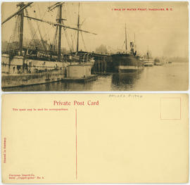
1 mile of water front, Vancouver, B.C.