
Suspension Bridge from Look-Out Point, Capilano Canyon, Vancouver, B.C. Canada
- AM1052-: AM1052 P-855-: AM1052 P-855.07
- Part
- [192-?]
Item is a postcard
11112 results with digital objects Show results with digital objects
Suspension Bridge from Look-Out Point, Capilano Canyon, Vancouver, B.C. Canada
Item is a postcard

Suspension Bridge, Capilano Canyon, Vancouver, B.C. Canada
Item is a postcard

The Lions and Capilano River, Vancouver, B.C. Canada
Item is a postcard

Suspension Bridge, Height 450 ft, Capilano Canyon, Vancouver, B.C. Canada
Item is a postcard

Enclosure for set of Capilano Canyon postcards
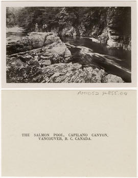
The Salmon Pool, Capilano Canyon, Vancouver, B.C., Canada
Item is a postcard
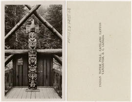
Indian Totem Pole, Capilano Canyon, Vancouver, B.C. Canada
Item is a postcard
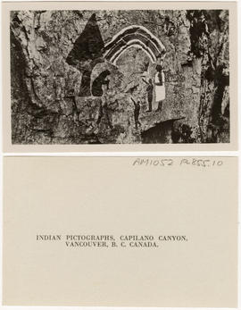
Indian Pictographs, Capilano Canyon, Vancouver, B.C. Canada
Item is a postcard
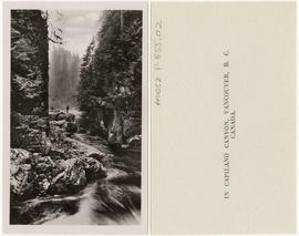
In Capilano Canyon, Vancouver, B.C. Canada
Item is a postcard
![Suspension Bridge, Capilano Canyon, Height 200 ft,, Lentgh [Length] 450 ft, Vancouver, B.C. Canada](/uploads/r/null/5/5/a/55a2c61dc1b86111d8c33c8242c4f1d14cc6a09c4db9ef1e7b0664fbeb991b45/ae7ddc36-6a5f-42f2-9c06-b7a0bfc3fab9-AM1052P-855_142.jpg)
Suspension Bridge, Capilano Canyon, Height 200 ft,, Lentgh [Length] 450 ft, Vancouver, B.C. Canada
Item is a postcard

View from Suspension Bridge, Capilano Canyon, B.C. Canada
Item is a postcard

Part of City of Vancouver Archives technical and cartographic drawing collection
Part depicts the upper left hand quadrant of the map, and includes a diagram of the solar system, a table of dimensions of bodies in the solar system, a chart of constellations viewable in the northern hemisphere, text on geographical definiations and the cause of the tides, and a map of the northern half of the Americas.
Dunn, Samuel

Part of City of Vancouver Archives technical and cartographic drawing collection
Part depicts text and accompanying diagram on "the art of dialing by a common globe", a chart of universal scale, a map of the world using Mercator's projection, a map of the southern half of the Americans, descriptions of the various maps and charts, and the left-hand side of a map of the lunar surface viewable from Earth.
Dunn, Samuel
Part of City of Vancouver Archives technical and cartographic drawing collection
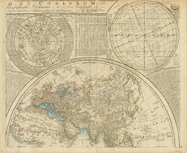
Part depicts a chart of the astronomical latitude & longitude analemma, a table showing values of the place of the sun in the ecliptic & declinatiobn, a chart of the constellations viewable in the southern hemisphere, text on geographical definitions and the cause of the tides, and a map of the northern portion of Africa, Europe and Asia.
Dunn, Samuel

Part of City of Vancouver Archives technical and cartographic drawing collection
Part depicts the right-hand side of a map of the lunar surface viewable from Earth, a chart of the Analemma, a chart and accompanying text entitled "the vicissitude of seasons explained", a chart and accompanying text on "the art of dialing by a common globe", and a map of the southern portion of Africa and Asia, as well as Australia.
Dunn, Samuel
Part of City of Vancouver Archives technical and cartographic drawing collection
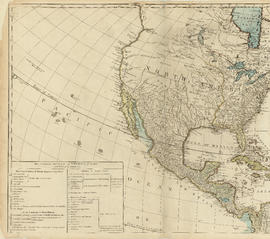
Part is the top left hand quadrant of a map of the Americas, and depicts North America and the north-west portion of South America. The sheet also includes a list of territories and islands in North America and appears to relate to territorial divisions as a result of the Treaty of Paris and the Treaty of Versailles (1783).
Part of City of Vancouver Archives technical and cartographic drawing collection
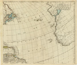
Part is the top right portion of a map of the Americas, and depicts the north-eastern portion of the Canadian coast, the eastern portion of the West Indies, the north-east corner of South America and the coastal areas of south-west Europe and wesern Africa.

Part of City of Vancouver Archives technical and cartographic drawing collection
Part contains a map showing block and lot numbers of properties in the area bounded by Campbell Street (Alma Street), Richards Street (Balaclava Street), English Bay, and present-day 15th Avenue (not named on map).

Advertisements for Vancouver real estate
Part of City of Vancouver Archives technical and cartographic drawing collection

Vancouver, B.C., Pacific terminus of the C.P.R.
Part of City of Vancouver Archives technical and cartographic drawing collection
Part is the front page of an unfoldedd brochure. The text describes Vancouver's growth and prospects for the future. Illustrations of different buildings in Vancouver and some parks are also shown.
Ross and Ceperley (Vancouver, B.C.)
City of Vancouver. Canadian Pacific town site
Part of City of Vancouver Archives technical and cartographic drawing collection
Part is a map sheet with one principal map, three inset maps and one illustration. The main map is a copy of a L.A. Hamilton map of downtown Vancouver and the land surrounding False Creek. Textual information is provided about the history and layout of Stanley Park. Inset maps show the Canadian Pacific mail steamships lines around the world and an index plan of Vancouver, B.C.
![Vancouver, B.C., the Pacific coast terminus of the C.P.R. [Canadian Pacific Railway]](/uploads/r/null/e/2/c/e2cdc004f3cf462100ed2ef053aa6087887b3f3200917cd5fba6292afb3b2d2d/bfcde3fa-32d7-4d08-86e5-ecf70c6f8388-LEG1340_142.jpg)
Vancouver, B.C., the Pacific coast terminus of the C.P.R. [Canadian Pacific Railway]
Part of City of Vancouver Archives technical and cartographic drawing collection
Part contains text and engravings describing Vancouver's climate, resources, industries, and buildings.

Part of City of Vancouver Archives technical and cartographic drawing collection
Part contains information on Delta, Chilliwhack [sic], Surrey, New Westminster, Maple Ridge, Langley, and British Columbia.

City of Vancouver : Canadian Pacific town site
Part of City of Vancouver Archives technical and cartographic drawing collection
Part contains four maps. The main map shows district lots and block numbers in Vancouver from Vine Street in the west to Boundary Avenue (Glen Drive) in the east and Stanley Park in the north to 9th Avenue (Broadway) in the south. Three smaller maps include an index plan to district lots in Vancouver, South Vancouver, New Westminster, and Burnaby; a world map showing Canadian Pacific mail steamship lines; and an index plan of Vancouver city limits. Part has been annotated with text describing a June 1888 land clearance plan and hand colouring indicating clearance status.

Map of the municipalities of New Westminster City and District, British Columbia
Part of City of Vancouver Archives technical and cartographic drawing collection
Part contains a map of the Lower Mainland and Fraser Valley from the Gulf of Georgia in the west to Harrison Lake in the east. Map shows locations of churches, schools, canneries, sawmills, brickyards, tanneries, woolen mills and hatcheries; existing and proposed railways; and roadways.

Information concerning the City and District of New Westminster and the Province of British Columbia
Part of City of Vancouver Archives technical and cartographic drawing collection
Part is the text side of a pamphlet. This part contains information concerning the city and district of New Westminster, with individual panels on the municipalities of Delta, Chilliwhack [sic], Surrey, Langley, and Delta, and the City of New Westminster, the town of Harrison Hot Springs and the province.
![Vancouver, B.C., the Pacific coast terminus of the C.P.R. [Canadian Pacific Railway]](/uploads/r/null/8/3/f/83fcf65f0d66d64e6357d0d647e0ea6e2fa4aae4c3d1919f952d7725b4299cda/623e750c-fbab-43b7-a496-d20b384baeb6-LEG1321_142.jpg)
Vancouver, B.C., the Pacific coast terminus of the C.P.R. [Canadian Pacific Railway]
Part of City of Vancouver Archives technical and cartographic drawing collection
Part contains text and engravings describing Vancouver's climate, resources, industries, and buildings. Cover page is stamped "Arthur McMullen."

City of Vancouver : Canadian Pacific town site
Part of City of Vancouver Archives technical and cartographic drawing collection
Part contains four maps. The main map shows district lots and block numbers in Vancouver from Vine Street in the west to Boundary Avenue (Glen Drive) in the east and Stanley Park in the north to 9th Avenue (Broadway) in the south. Three smaller maps include an index plan to district lots in Vancouver, South Vancouver, New Westminster, and Burnaby; a world map showing Canadian Pacific mail steamship lines; and an index plan of Vancouver city limits.

Map of the municipalities of New Westminster, British Columbia
Part of City of Vancouver Archives technical and cartographic drawing collection
Part consists of the map component of a pamphlet. The map shows the location of churches, school, canaries, sawmills, backyards, tanneries, woolen mills, hatcheries, roads, and railways on a map which depicts the area of Greater Vancouver from the Gulf of Georgia east to Harrison Lake and south to the United States border.

Part of City of Vancouver Archives technical and cartographic drawing collection
Part is the inner sheet of an unfolded brochure, showing lots offered for sale in the northern portion of District Lot 540.
Souvenir from the lion gateway
Part of City of Vancouver Archives technical and cartographic drawing collection
Part is the front side of an unfolded promotional brochure. The various panels include promotional information on Vancouver, the economy, projected population growth and communications. The part includes four maps: Map of the New Westminster District, Map

City of Vancouver. Fifth Sale. Lots and blocks in Lot 540
Part of City of Vancouver Archives technical and cartographic drawing collection
Part is the outer sheet of an unfolded brochure advertising the sale of lots owned by the provincial government. The map included in the sheet is an index map of greater Vancouver, showing the location of District Lot 540.
Part of City of Vancouver Archives technical and cartographic drawing collection
Part is an illustrated map. The central panel is an oblique aerial view of downtown Vancouver, depicting buildings, industry along Burrard Inlet, and the street grid. Surrounding the map are small panels depicting buildings of note in Vancouver.

City of Vancouver. Canadian Pacific town site
Part of City of Vancouver Archives technical and cartographic drawing collection
Part is a map sheet with one principal map, three inset maps and one illustration. The main map is a copy of a L.A. Hamilton map of downtown Vancouver and the land surrounding False Creek. Textual information is provided about the history and layout of Stanley Park. Inset maps show the Canadian Pacific mail steamships lines around the world and an index plan of Vancouver, B.C. An illustration is incuded of the north shore mountains as seen from Vancouver.

Vancouver, B.C., Pacific terminus of the C.P.R.
Part of City of Vancouver Archives technical and cartographic drawing collection
Part is the front page of an unfoldedd brochure. The text describes Vancouver's growth and prospects for the future. Illustrations of different buildings in Vancouver and some parks are also shown.
Ross and Ceperley (Vancouver, B.C.)

Vest pocket map of Vancouver : map A
Part of City of Vancouver Archives technical and cartographic drawing collection
Part contains a key plan for the larger maps, textual information about Vancouver, and a map of the West End and downtown Vancouver.

Vest pocket map of Vancouver : map C
Part of City of Vancouver Archives technical and cartographic drawing collection
Part shows Vancouver from Boundary Street (Alma Street) to Heather Street and English Bay/False Creek to Sixteenth Avenue west of Boundary Street (Trafalgar Street) and to Ninth Avenue (Broadway) east of Vine Street. Shows district lot and block numbers, public schools, and hospitals.

Vest pocket map of Vancouver : map D
Part of City of Vancouver Archives technical and cartographic drawing collection
Part shows Vancouver from Heather Street to Garden Drive and Grant Street to Sixteenth Avenue. Shows district lot and block numbers, public schools, and hospitals.

Vest pocket map of Vancouver : map cover
Part of City of Vancouver Archives technical and cartographic drawing collection

Vest pocket map of Vancouver : map B
Part of City of Vancouver Archives technical and cartographic drawing collection
Part shows Vancouver from Westminster Avenue (Main Street) to Garden Drive and Burrard Inlet to Grant Street. Shows district lot and block numbers, public schools, and hospitals.

Part of City of Vancouver Archives technical and cartographic drawing collection
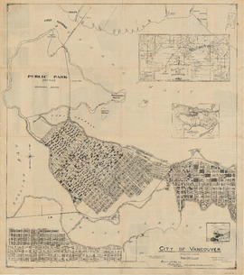
Part contains a map of East Vancouver Heights showing streets, block numbers and lot numbers, an index map showing the location of East Vancouver Heights in relation to the rest of the city, and text promoting the area.

Part of City of Vancouver Archives technical and cartographic drawing collection
Part is the right-hand half of a map sheet that has been mounted onto linen. The sheet shows Vancouver streets, District Lots, blocks and lots as well as main city infrastructure from Willow Street to the eastern edge of the City.

Part of City of Vancouver Archives technical and cartographic drawing collection
Part is the left-hand half of a map sheet that has been mounted onto linen. The sheet shows Vancouver streets, District Lots, blocks and lots as well as main city infrastructure from the western edge of the City east to Willow Street. The inset map shows Stanley Park.
Bird's eye view of Vancouver, B.C.
Part of City of Vancouver Archives technical and cartographic drawing collection
Part contains an illustrated oblique view of Vancouver showing steamship lines, bridges, beaches, major roads, and the location and block numbers of East Vancouver Heights.
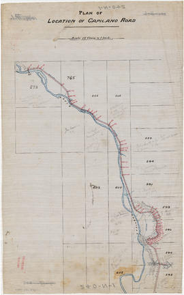
Part of City of Vancouver fonds
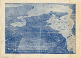
Part is the northern half of a map of the Capilano River, depicting the area of the Capilano River valley from District Lots 595 and 602 north to the dam located in District Lot 673.

Part of City of Vancouver fonds
Part is the southern half of a map of the Capilano River, depciting the area of the Capilano River valley from the river's mouth at Burrard Inlet north to District Lot 596.
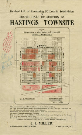
Revised list of remaining 50 lots in subdivision of south half of section 35, Hastings Townsite
Part of City of Vancouver Archives technical and cartographic drawing collection
Part contains a map showing lots for sale in the area bounded by Slocan Street, Renfrew Street, 9th Avenue, and 13th Avenue, and textual information for potential buyers. Annotations indicate which lots were sold.
![Hastings Townsite [Boundary Road to 5th Avenue to Kamloops Street (?) to 33rd Avenue]](/uploads/r/null/7/f/0/7f0fe2a27b9af4f20ad7837792af3bbb3aa93c3487024e69b14fa38144134f19/8e7a0e66-c6cc-40ca-bbac-4ea73db77437-LEG1800_142.jpg)
Hastings Townsite [Boundary Road to 5th Avenue to Kamloops Street (?) to 33rd Avenue]
Part of City of Vancouver Archives technical and cartographic drawing collection
Part consists of a portion of the map, depicting the area approximately bounded by Boundary Road, 5th Avenue, Kamloops Street (?) and 33rd Avenue.
Part of City of Vancouver Archives technical and cartographic drawing collection
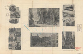
Part contains promotional images of Vancouver including residences, Stanley Park, English Bay, and Hastings Street.

Map and views of the terminal city, Vancouver, British Columbia, Canada : map cover
Part of City of Vancouver Archives technical and cartographic drawing collection
Part is the cover for a fold-out map of Vancouver and contains advertisements for the East End Stationery Store.