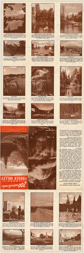
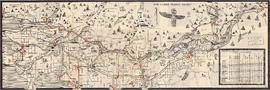
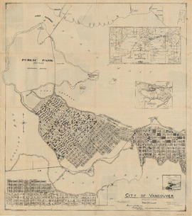
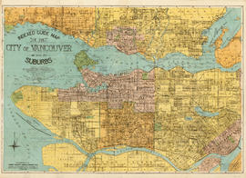
Showing 281 results

Archival description
City of Vancouver Archives technical and cartographic drawing collection
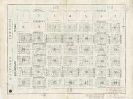
 Part English
Print preview View:

246 results with digital objects Show results with digital objects

Inset maps and indexes

Part is the verso side of the pamphlet, which includes a street index, list of places of general interst and their location on on the main map, a list of B.C.E.R. routes, and an index of schools shown on the map. The page includes two inset maps, one of downtown Vancouver and one of Richmond, including a road index.

Tourist map of Greater Vancouver

Part is a sheet with two maps. The main map shows a pictorial view of Greater Vancouver, including the location of major roads and tourist attractions. Drawings of "the most important single objects on totem poles of the Pacific Northwest Indians" form a decorative border. The inset map shows downtown Granville Street and the location of the Scenery Shop.

Along the gulf coast riviera by Union Steamships

Part is the outer/front side of an unfolded brochure for Union Steamships Limited. The sheet described various tourist destinations along the southern coast that could be reached by Union Steamships services, with information on sights, fares, etc. The sheet also includes photographs of recreation areas around Sechelt.

Union Steamships (Vancouver, B.C.)

City of Vancouver. Canadian Pacific town site

Part is a map sheet with one principal map, three inset maps and one illustration. The main map is a copy of a L.A. Hamilton map of downtown Vancouver and the land surrounding False Creek. Textual information is provided about the history and layout of Stanley Park. Inset maps show the Canadian Pacific mail steamships lines around the world and an index plan of Vancouver, B.C.

City of Vancouver. Canadian Pacific town site

Part is a map sheet with one principal map, three inset maps and one illustration. The main map is a copy of a L.A. Hamilton map of downtown Vancouver and the land surrounding False Creek. Textual information is provided about the history and layout of Stanley Park. Inset maps show the Canadian Pacific mail steamships lines around the world and an index plan of Vancouver, B.C. An illustration is incuded of the north shore mountains as seen from Vancouver.

Map and Guide to Vancouver Street Car and Interurban Lines

Part is the front side of an informational pamphlet published by the BC Electric Railway Co. regarding City streetcar routes and interurban lines, golf and country clubs, city trips, interurban trips, motor coach trips, stations, ferries and docks, bathing beaches, public parks, North Shore canyons and parks, athletic and amusement parks.

Top left plate

Part depicts the upper left hand quadrant of the map, and includes a diagram of the solar system, a table of dimensions of bodies in the solar system, a chart of constellations viewable in the northern hemisphere, text on geographical definiations and the cause of the tides, and a map of the northern half of the Americas.

Dunn, Samuel

Top right plate

Part depicts a chart of the astronomical latitude & longitude analemma, a table showing values of the place of the sun in the ecliptic & declinatiobn, a chart of the constellations viewable in the southern hemisphere, text on geographical definitions and the cause of the tides, and a map of the northern portion of Africa, Europe and Asia.

Dunn, Samuel

Bottom left plate

Part depicts text and accompanying diagram on "the art of dialing by a common globe", a chart of universal scale, a map of the world using Mercator's projection, a map of the southern half of the Americans, descriptions of the various maps and charts, and the left-hand side of a map of the lunar surface viewable from Earth.

Dunn, Samuel

Bottom right plate

Part depicts the right-hand side of a map of the lunar surface viewable from Earth, a chart of the Analemma, a chart and accompanying text entitled "the vicissitude of seasons explained", a chart and accompanying text on "the art of dialing by a common globe", and a map of the southern portion of Africa and Asia, as well as Australia.

Dunn, Samuel

Map of the municipalities of New Westminster, British Columbia

Part consists of the map component of a pamphlet. The map shows the location of churches, school, canaries, sawmills, backyards, tanneries, woolen mills, hatcheries, roads, and railways on a map which depicts the area of Greater Vancouver from the Gulf of Georgia east to Harrison Lake and south to the United States border.

Information concerning the City and District of New Westminster and the Province of British Columbia

Part is the text side of a pamphlet. This part contains information concerning the city and district of New Westminster, with individual panels on the municipalities of Delta, Chilliwhack [sic], Surrey, Langley, and Delta, and the City of New Westminster, the town of Harrison Hot Springs and the province.

Visitors map of Vancouver

Part is the front sheet of an unfolded tourism brochure showing Vancouver tourist attractions, The sheet includes a map of downtown Vancouver, with transportation information, a map of the roads in Stanley Park, photographs and information on various sites and attractions in the city, as well as general promotional information.

Top left plate

Part is the top left hand quadrant of a map of the Americas, and depicts North America and the north-west portion of South America. The sheet also includes a list of territories and islands in North America and appears to relate to territorial divisions as a result of the Treaty of Paris and the Treaty of Versailles (1783).

Results 1 to 50 of 281