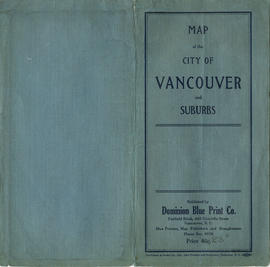
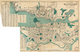
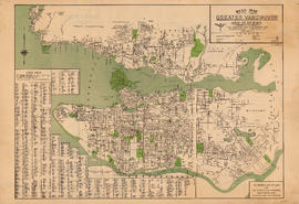
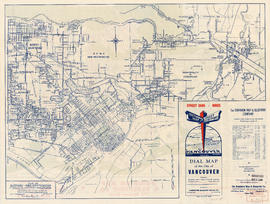
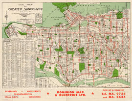
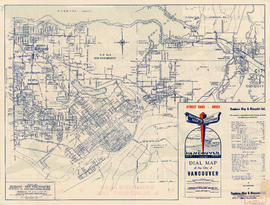
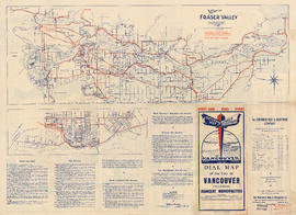
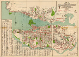
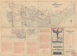
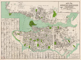
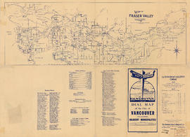
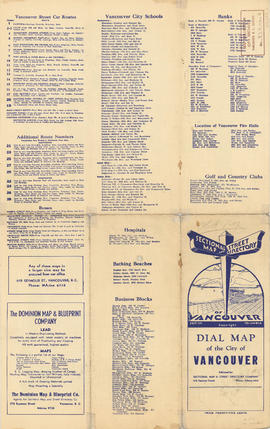
Showing 58 results

Archival description
Dominion Map and Blueprint Company fonds Part
Print preview View:

38 results with digital objects Show results with digital objects

Dial map of Greater Vancouver

Part consists of a street map of Vancouver showing block numbers, street car, bus, and railway lines, parks and hospitals. Map includes a dial (a numbered circle, a paper indicator, a grid of block numbers and a street index used to find locations).

Dial map of Vancouver and suburbs

Part consists of a street map of Vancouver, West Vancouver, North Vancouver, and Burnaby. Part includes the printed portion of the dial (a numbered circle, a grid of block numbers and a street index used to find locations), but no indicator is attached.

Greater Vancouver

Map shows boundaries, lot numbers and major roads in Greater Vancouver (including West Vancouver, North Vancouver, the City of North Vancouver, the City of Vancouver, Coquitlam, Point Grey, South Vancouver, Burnaby, New Westminster, Port Moody, Port Coquitlam, Pitt Meadows, Surrey, Langley, Delta and Richmond).

Dial map of Greater Vancouver and suburbs

Part contains a street map of Vancouver, West Vancouver, North Vancouver, and Burnaby showing railways, hospitals, parks and block numbers. The map includes the printed portion of the dial (a numbered circle, a grid of block numbers and a street index used to find locations), but no indicator is attached. A small inset shows the streets of Gleneagles in West Vancouver.

Dial map of Greater Vancouver

Part contains a street map of Vancouver showing streets, block numbers, bus routes, railway lines, boundaries, private roads and hospitals. The map includes a dial (a numbered circle, a paper indicator, a grid of block numbers and a street index used to find locations in Vancouver). A small inset map shows the streets surrounding Queen Elizabeth Park, which are obscured on the main map where the indicator is attached.

Dial map of Greater Vancouver

Item is a map showing street car lines, bus lines, block numbers, railway lines, boundaries and hospitals in Vancouver. The map includes the printed portion of the dial (a numbered circle, a grid of block numbers and a street index used to find locations in Vancouver), but no indicator is attached.

Dial map of Greater Vancouver and suburbs

Part contains a street map of Vancouver, West Vancouver, North Vancouver and Burnaby showing streets, block numbers, bus routes, railway lines, boundaries, private roads and hospitals. The map includes a dial (a numbered circle, a paper indicator, a grid of block numbers and a street index used to find locations).

Map of Fraser Valley

Part consists of a map showing the Lower Mainland from Vancouver to Chilliwack, including major roadways, rail and bus lines, and a smaller street map of New Westminster. Part includes information on bus and street car lines in Vancouver, West Vancouver, North Vancouver, and Burnaby, as well as text advertising the products and services of the Dominion Map and Blueprint Company.

Dial map of Greater Vancouver and suburbs

Part contains a street map of Vancouver, West Vancouver, North Vancouver and Burnaby showing streets, block numbers, bus routes, railway lines, boundaries, private roads and hospitals. The map includes the printed portion of the dial (a numbered circle, a grid of block numbers and a street index used to find locations), but no indicator is attached.

Map of Fraser Valley

Part consists of a map showing the Lower Mainland from Vancouver to Chilliwack, including major roadways, rail and bus lines, and a smaller street map of New Westminster. Part includes information on bus and street car lines in Vancouver, West Vancouver, North Vancouver, and Burnaby, as well as text advertising the products and services of the Dominion Map and Blueprint Company.

Dial map of Greater Vancouver and suburbs

Part contains a street map of Vancouver, West Vancouver, North Vancouver, and Burnaby showing railways, hospitals, parks and block numbers. The map includes the printed portion of the dial (a numbered circle, a grid of block numbers and a street index used to find locations), but no indicator is attached. Two small insets show the streets of Gleneagles in West Vancouver and Norgate Park in North Vancouver.

Dial map of Greater Vancouver and suburbs

Part contains a street map of Vancouver, West Vancouver, North Vancouver, and Burnaby showing railways, hospitals, parks and block numbers. The map includes a dial (a numbered circle, a paper indicator, a grid of block numbers and a street index used to find locations). A small inset shows the streets of Gleneagles Park in West Vancouver.

Dial map of Greater Vancouver and suburbs

Part contains a street map of Vancouver, Burnaby, New Westminster, West Vancouver, and North Vancouver showing railways, hospitals, parks and block numbers. The map includes two dials (numbered circles, paper indicators, a grid of block numbers and a street index used to find locations).

Map of Fraser Valley

Part consists of a map showing major roadways in the Lower Mainland and the Fraser Valley from Vancouver to Chilliwack, and lists of Vancouver businesses, schools, public buildings, hospitals, bathing beaches, fire halls, and golf and country clubs. Part includes text advertising the products and services of the Dominion Map and Blueprint Company.

Dial map of Greater Vancouver

Part contains a street map of Vancouver showing streets, block numbers, bus routes, railway lines, boundaries, private roads and hospitals. The map includes a dial (a numbered circle, a paper indicator, a grid of block numbers and a street index used to find locations in Vancouver). A small inset shows the streets surrounding Queen Elizabeth Park, which are obscured on the main map where the indicator is attached.

Map of Fraser Valley

Part consists of a street map of the Lower Mainland and Fraser Valley from Vancouver to Chilliwack, a street map of New Westminster, a map of Vancouver and North Vancouver showing street names but not street lines, and text advertising the products and services of the Dominion Map and Blueprint Company.

Five regional British Columbia maps

Part is a sheet with five road maps showing routes on Vancouver Island, routes from Vancouver to Prince George, routes in the Okanagan, routes between Nelson, Revelstoke and Calgary and routes between Vancouver and San Francisco.

City of Vancouver

Part is a map of the City of Vancouver showing block numbers, street car lines and numbers, fire halls, hospitals, electric and steam railways and bus routes. The map includes a 'dial', and associated street index used to find locations.

Hotel Grosvenor

Part is a page of promotional and descriptive information about Vancouver, the Hotel Grosvenor and Douglas Lodge. The page includes a map showing the location of Douglas Lodge on Stuart Lake, near Fort St. James, B.C.

Results 1 to 50 of 58