
Wrigley's offical arrow city map : Greater Vancouver and New Westminster : map cover
- AM1594-: MAP 771-: LEG1315.8
- Part
- 1936
Part of City of Vancouver Archives technical and cartographic drawing collection
Wrigley's offical arrow city map : Greater Vancouver and New Westminster : map cover
Part of City of Vancouver Archives technical and cartographic drawing collection

Wrigley's new map of Vancouver and Lower Mainland
Part of City of Vancouver Archives technical and cartographic drawing collection
Part contains a map showing streets and block numbers in Vancouver, West Vancouver, North Vancouver, Burnaby, New Westminster and the northern part of Richmond.

Wrigley's 1930 map of Vancouver and Lower Mainland
Part of City of Vancouver Archives technical and cartographic drawing collection
Part contains a map of Greater Vancouver showing streets, paved streets, trails, street car lines, bus lines, railways, auto camps, hospitals, schools and block numbers. Concentric circles spaced one mile apart emanate from a point in downtown Vancouver.
Where to go, what to do, how to see Vancouver
Part of City of Vancouver Archives technical and cartographic drawing collection
Part consists of photographs of prominent tourist sites in Vancouver, with accompanying descriptive text.

What the man who comes to Vancouver wants to know
Part of City of Vancouver Archives technical and cartographic drawing collection
Part contains information on lodging, restaurants, transit, social clubs, and other points of interest in Vancouver.

Visitors map of Vancouver ; world famous Stanley Park ; downtown Vancouver
Part of City of Vancouver Archives technical and cartographic drawing collection
Part contains detail maps of Stanley Park and downtown Vancouver, tourist information including traffic rules, locations of churches, golf courses, and amenities, and a list of member businesses of the Vancouver Tourist Association.

Part of City of Vancouver Archives technical and cartographic drawing collection
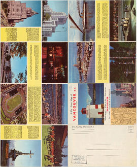
Part is the front sheet of an unfolded tourism brochure showing Vancouver tourist attractions, The sheet includes a map of downtown Vancouver, with transportation information, a map of the roads in Stanley Park, photographs and information on various sites and attractions in the city, as well as general promotional information.

Part of City of Vancouver Archives technical and cartographic drawing collection
Part contains an illustrated map of Greater Vancouver showing major streets and tourist attractions.

Part of City of Vancouver Archives technical and cartographic drawing collection
Part is the reverse side of a tourism brochure, containing a tourist map of Greater Vancouver, showing major roads, locations of tourist attractions and recreational sites, and routes into Vancouver.

Part of City of Vancouver Archives technical and cartographic drawing collection
Part is one side of a brochure for the Scenery Shop, displaying images , descriptions and prices of various souvenirs available.
Part of City of Vancouver Archives technical and cartographic drawing collection
Part contains promotional images of Vancouver including residences, Stanley Park, English Bay, and Hastings Street.

Victoria, vicinity and Vancouver Island
Part of City of Vancouver Archives technical and cartographic drawing collection
Part is a sheet with three maps: a street map of Victoria, a map of major roads and highways in Greater Victoria, and a highway map of Vancouver Island. The sheet includes street indexes and a mileage chart.

Vest pocket map of Vancouver : map D
Part of City of Vancouver Archives technical and cartographic drawing collection
Part shows Vancouver from Heather Street to Garden Drive and Grant Street to Sixteenth Avenue. Shows district lot and block numbers, public schools, and hospitals.

Vest pocket map of Vancouver : map cover
Part of City of Vancouver Archives technical and cartographic drawing collection

Vest pocket map of Vancouver : map C
Part of City of Vancouver Archives technical and cartographic drawing collection
Part shows Vancouver from Boundary Street (Alma Street) to Heather Street and English Bay/False Creek to Sixteenth Avenue west of Boundary Street (Trafalgar Street) and to Ninth Avenue (Broadway) east of Vine Street. Shows district lot and block numbers, public schools, and hospitals.

Vest pocket map of Vancouver : map B
Part of City of Vancouver Archives technical and cartographic drawing collection
Part shows Vancouver from Westminster Avenue (Main Street) to Garden Drive and Burrard Inlet to Grant Street. Shows district lot and block numbers, public schools, and hospitals.

Vest pocket map of Vancouver : map A
Part of City of Vancouver Archives technical and cartographic drawing collection
Part contains a key plan for the larger maps, textual information about Vancouver, and a map of the West End and downtown Vancouver.

Vancouver, British Columbia, Canada
Part of City of Vancouver Archives technical and cartographic drawing collection
Part is a pictorial map noting the locations of main tourist sites described on the other side of the sheet. The sheet includes an index of points of special interest.
Bloodgood, Don
Part of City of Vancouver Archives technical and cartographic drawing collection
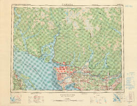
Part contains a map of the Greater Vancouver area showing topographic contour lines at 500-foot intervals, roads and road characteristics, railways, parks, towns, reserves, elevations, airports, streams, lakes, and adminstrative boundaries. Includes a key plan of adjoining sheets published in the same series and a small ancillary map showing the declination of the compass needle in 1958.
![Vancouver, B.C., the Pacific coast terminus of the C.P.R. [Canadian Pacific Railway]](/uploads/r/null/8/3/f/83fcf65f0d66d64e6357d0d647e0ea6e2fa4aae4c3d1919f952d7725b4299cda/623e750c-fbab-43b7-a496-d20b384baeb6-LEG1321_142.jpg)
Vancouver, B.C., the Pacific coast terminus of the C.P.R. [Canadian Pacific Railway]
Part of City of Vancouver Archives technical and cartographic drawing collection
Part contains text and engravings describing Vancouver's climate, resources, industries, and buildings. Cover page is stamped "Arthur McMullen."
![Vancouver, B.C., the Pacific coast terminus of the C.P.R. [Canadian Pacific Railway]](/uploads/r/null/e/2/c/e2cdc004f3cf462100ed2ef053aa6087887b3f3200917cd5fba6292afb3b2d2d/bfcde3fa-32d7-4d08-86e5-ecf70c6f8388-LEG1340_142.jpg)
Vancouver, B.C., the Pacific coast terminus of the C.P.R. [Canadian Pacific Railway]
Part of City of Vancouver Archives technical and cartographic drawing collection
Part contains text and engravings describing Vancouver's climate, resources, industries, and buildings.

Vancouver, B.C., Pacific terminus of the C.P.R.
Part of City of Vancouver Archives technical and cartographic drawing collection
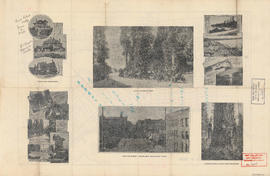
Part is the front page of an unfoldedd brochure. The text describes Vancouver's growth and prospects for the future. Illustrations of different buildings in Vancouver and some parks are also shown.
Ross and Ceperley (Vancouver, B.C.)

Vancouver, B.C., Pacific terminus of the C.P.R.
Part of City of Vancouver Archives technical and cartographic drawing collection
Part is the front page of an unfoldedd brochure. The text describes Vancouver's growth and prospects for the future. Illustrations of different buildings in Vancouver and some parks are also shown.
Ross and Ceperley (Vancouver, B.C.)

Vancouver, B.C. zoning diagram
Part of City of Vancouver Archives technical and cartographic drawing collection
Part is the front side of an unfolded pamphlet. The sheet contains general information on historical events, why planning is conducted, zoning, general facts about the city and the province, a statement of purpose for town planning, and a list of applicable statutes.

Part of City of Vancouver Archives technical and cartographic drawing collection
Part contains a street map of Greater Vancouver showing highways, municipal boundaries, parks and golf courses.

Part of City of Vancouver Archives technical and cartographic drawing collection

Part of City of Vancouver Archives technical and cartographic drawing collection
Part is a sheet depicting 2 maps, showing Burrard Inlet and major connecting traffic infrastructure, and 5 photographs of port facilities.

Vancouver city and suburban lines
Part of City of Vancouver Archives technical and cartographic drawing collection
Part consists of a map of streetcar and interurban rail lines in Vancouver.

Vancouver city and suburban lines
Part of City of Vancouver Archives technical and cartographic drawing collection
Part is the back side of an informational pamphlet published by the BC Electric Railway Co. showing street car lines, interurban lines, bus routes and parks.

Vancouver city and suburban lines
Part of City of Vancouver Archives technical and cartographic drawing collection
Part consists of a map of streetcar and interurban rail lines in Vancouver.

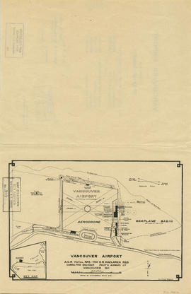
Vancouver airport. Design for Spanish Banks
Part of City of Vancouver Archives technical and cartographic drawing collection
Part is the front page of a brochure, showing cost estimates for various elements of the development.
Part of City of Vancouver Archives technical and cartographic drawing collection
Part is a map shows a proposed plan for the design of Vancouver Airport at Spanish Banks, along with surrounding gardens, a stadium, parks and beaches.

Vancouver - the third largest city of the dominion, and Canada's chief Pacific port
Part of City of Vancouver Archives technical and cartographic drawing collection
Part contains information on Vancouver's history and government, and on the purpose and benefits of town planning.

Transit system map of Greater Vancouver, B.C.
Part of City of Vancouver Archives technical and cartographic drawing collection
Part contains a map of Greater Vancouver showing bus lines, route numbers, B.C. Electric installations, block numbers, points of interest and amenities; an inset map showing streets in Gleneagles, Whytecliff, and Horseshoe Bay; and an inset map showing streets in Port Moody, Coquitlam, and Maillardville.

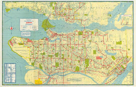
Transit system map of Greater Vancouver, B.C.
Part of City of Vancouver Archives technical and cartographic drawing collection
Part is a map sheet with a main map showing the various B.C. Electric transit routes in Greater Vancouver, including Vancouver, Richmond, North Vancouver, Burnaby and New Westminster.

Transit system map of Greater Vancouver, B.C.
Part of City of Vancouver Archives technical and cartographic drawing collection
Part contains a map of Greater Vancouver showing bus lines, route numbers, B.C. Electric installations, block numbers, points of interest and amenities; an inset map showing streets in Gleneagles, Whytecliff, and Horseshoe Bay; and an inset map showing streets in Port Moody, Coquitlam, and Maillardville.
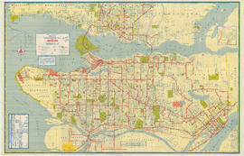
Transit system map of Greater Vancouver
Part of City of Vancouver Archives technical and cartographic drawing collection
Part is a map showing the routes of various BC Electric transit services. The inset map shows the Forest Hills/Canyon Heights area. The map also includes a guide to Vancouver street numbers.

Tourist map of Greater Vancouver
Part of City of Vancouver Archives technical and cartographic drawing collection
Part is a sheet with two maps. The main map shows a pictorial view of Greater Vancouver, including the location of major roads and tourist attractions. Drawings of "the most important single objects on totem poles of the Pacific Northwest Indians" form a decorative border. The inset map shows downtown Granville Street and the location of the Scenery Shop.
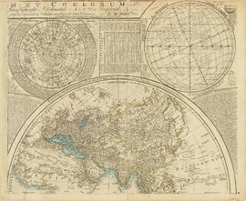
Part of City of Vancouver Archives technical and cartographic drawing collection
Part depicts a chart of the astronomical latitude & longitude analemma, a table showing values of the place of the sun in the ecliptic & declinatiobn, a chart of the constellations viewable in the southern hemisphere, text on geographical definitions and the cause of the tides, and a map of the northern portion of Africa, Europe and Asia.
Dunn, Samuel
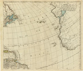
Part of City of Vancouver Archives technical and cartographic drawing collection
Part is the top right portion of a map of the Americas, and depicts the north-eastern portion of the Canadian coast, the eastern portion of the West Indies, the north-east corner of South America and the coastal areas of south-west Europe and wesern Africa.

Part of City of Vancouver Archives technical and cartographic drawing collection
Part depicts the upper left hand quadrant of the map, and includes a diagram of the solar system, a table of dimensions of bodies in the solar system, a chart of constellations viewable in the northern hemisphere, text on geographical definiations and the cause of the tides, and a map of the northern half of the Americas.
Dunn, Samuel
Part of City of Vancouver Archives technical and cartographic drawing collection
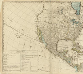
Part is the top left hand quadrant of a map of the Americas, and depicts North America and the north-west portion of South America. The sheet also includes a list of territories and islands in North America and appears to relate to territorial divisions as a result of the Treaty of Paris and the Treaty of Versailles (1783).

Tidal current charts, Vancouver Harbour, British Columbia : front cover
Part of City of Vancouver Archives technical and cartographic drawing collection

Tidal current charts, Vancouver Harbour : inside front cover
Part of City of Vancouver Archives technical and cartographic drawing collection
Part contains explanatory text to be used in conjunction with the tidal current charts in the booklet.

Tidal current chart, Vancouver Harbour : two hours before maximum flood at First Narrows
Part of City of Vancouver Archives technical and cartographic drawing collection

Tidal current chart, Vancouver Harbour : two hours before maximum ebb at First Narrows
Part of City of Vancouver Archives technical and cartographic drawing collection

Tidal current chart, Vancouver Harbour : two hours after maximum flood at First Narrows
Part of City of Vancouver Archives technical and cartographic drawing collection

Tidal current chart, Vancouver Harbour : two hours after maximum ebb at First Narrows
Part of City of Vancouver Archives technical and cartographic drawing collection