
Map of City of Vancouver, British Columbia
- AM738-S1-: MAP 903-: LEG1252.1
- Part
- [ca. 1930]
Map shows streets, schools, hospitals, street car lines, railways and address block numbers in Vancouver.
Map of City of Vancouver, British Columbia
Map shows streets, schools, hospitals, street car lines, railways and address block numbers in Vancouver.

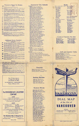
Information on transit and buildings in Vancouver
Part is the text side of a street map of Vancouver. Part also includes text advertisitng the products and services of the Dominion Map and Blueprint Company.

Part consists of a street map of Vancouver showing block numbers, street car, bus, and railway lines, parks and hospitals. Map includes a dial (a numbered circle, a paper indicator, a grid of block numbers and a street index used to find locations).

Part consists of a street map of the Lower Mainland and Fraser Valley from Vancouver to Chilliwack, a street map of New Westminster, a map of Vancouver and North Vancouver showing street names but not street lines, and text advertising the products and services of the Dominion Map and Blueprint Company.