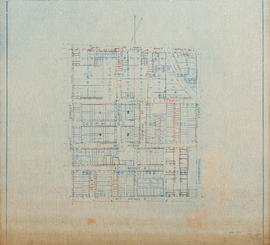
Water service map of South Vancouver : Knight Street to Commercial Street and 15th Avenue (16th Avenue) to 22nd Avenue
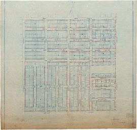
Water service map of South Vancouver : Knight Street to Victoria Drive and 22nd Avenue to 34th Ave (33rd Avenue)
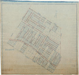
Water service map of South Vancouver : Knight Street to Victoria Drive and 34th Avenue (33rd Avenue) to 43rd Avenue (41st Avenue)
Water service map of South Vancouver : Knight Street to Victoria Drive and 43rd Avenue (41st Avenue) to 51st Avenue (49th Avenue)
Water service map of South Vancouver : Knight Street to Victoria Drive and 51st Avenue (49th Avenue) to 61st Avenue (59th Avenue)
Water service map of South Vancouver : Knight Street to Victoria Drive and 61st Avenue (59th Avenue) to North Arm of Fraser River
Water service map of South Vancouver : McHardy Street to Park Street (Boundary Road) and Government Street (29th Avenue) to Vanness Avenue
Water service map of South Vancouver : Ontario Street to Fraser Street and 33rd Avenue to 41st Avenue
Water service map of South Vancouver : Ontario Street to Fraser Street and 43rd Avenue (41st Avenue) to 51st Avenue (49th Avenue)
Water service map of South Vancouver : Ontario Street to Fraser Street and 51st Avenue (49th Avenue) to 61st Avenue (59th Avenue)
Water service map of South Vancouver : Ontario Street to Fraser Street and 61st Avenue (59th Avenue) to River Street (Marine Drive S.E.)
Water service map of South Vancouver : Ontario Street to Fraser Street and King Edward Avenue to 34th Avenue (33rd Avenue)
Water service map of South Vancouver : Ontario Street to Fraser Street and River Avenue (Marine Drive) to North Arm of Fraser River
Water service map of South Vancouver : Point Grey boundary to Ontario Street and River Avenue (Marine Drive S.W.) to North Arm of Fraser River
Water service map of South Vancouver : Rupert Street to Tyne Street and Vanness Avenue to School Road (School Avenue)
Water service map of South Vancouver : Slocan Street to Rupert Street and Vanness Avenue to School Road (School Avenue)
Water service map of South Vancouver : Tyne Street to Park Street (Boundary Road) and 46th Avenue (45th Avenue) to 56th Avenue (54th Avenue)
Water service map of South Vancouver : Tyne Street to Park Street (Boundary Road) and 56th Avenue (54th Avenue) to 67th Avenue (65th Avenue)
Water service map of South Vancouver : Tyne Street to Park Street (Boundary Road) and Vanness Avenue to 46th Avenue (45th Avenue)
Water service map of South Vancouver : Victoria Drive to Slocan Street and 27th Avenue to 35th Avenue (34th Avenue)
Water service map of South Vancouver : Victoria Drive to Vivan Street and 67th Avenue (65th Avenue) to North Arm of Fraser River
Water service map of South Vancouver : Victoria Drive to Vivian Street and 46th Avenue (45th Avenue) to 56th Avenue (54th Avenue)
Water service map of South Vancouver : Victoria Drive to Vivian Street and 56th Avenue (54th Avenue) to 67th Avenue (65th Avenue)
Water service map of South Vancouver : Victoria Drive to Wales Street and 35th Avenue (34th Avenue) to 46th Avenue (45th Avenue)
Water service map of South Vancouver : Vivian Street to Doman Street and 67th Avenue (65th Avenue) to North Arm of Fraser River
Water service map of South Vancouver : Vivian Street to Kerr Street and 46th Avenue (45th Avenue) to 56th Avenue (54th Avenue)
Water service map of South Vancouver : Vivian Street to Kerr Street and 56th Avenue (54th Avenue) to 67th Avenue (65th Avenue)
Water service map of South Vancouver : Wales Street to Churchill Street (Rupert Street) and New Westminster Road (Kingsway) to 46th Avenue (45th Avenue)
Wrigley's 1930 map of Vancouver and Lower Mainland