
Map and Guide to Vancouver Street Car and Interurban Lines

Vancouver city and suburban lines

Map of the municipalities of New Westminster, British Columbia

Information concerning the City and District of New Westminster and the Province of British Columbia

Tidal current charts, Vancouver Harbour, British Columbia : front cover

Tidal current charts, Vancouver Harbour : inside front cover

Tidal current chart, Vancouver Harbour : two hours before maximum ebb at First Narrows

Tidal current chart, Vancouver Harbour : one hour before maximum ebb at First Narrows

Tidal current chart, Vancouver Harbour : maximum ebb at First Narrows

Tidal current chart, Vancouver Harbour : one hour after maximum ebb at First Narrows

Tidal current chart, Vancouver Harbour : two hours after maximum ebb at First Narrows

Tidal current chart, Vancouver Harbour : three hours after maximum ebb at First Narrows

Tidal current chart, Vancouver Harbour : two hours before maximum flood at First Narrows

Tidal current chart, Vancouver Harbour : one hour before maximum flood at First Narrows

Tidal current chart, Vancouver Harbour : maximum flood at First Narrows

Tidal current chart, Vancouver Harbour : one hour after maximum flood at First Narrows

Tidal current chart, Vancouver Harbour : two hours after maximum flood at First Narrows

Tidal current chart, Vancouver Harbour : three hours after maximum flood at First Narrows

Tidal current chart, Vancouver Harbour : inside back cover

Dial map of Greater Vancouver and suburbs

Map of Lulu Island and Sea Island ; Municipality of Delta ; Municipality of Surrey ; Municipality of Langley ; Map of Maillardville

Vancouver, B.C. city map : street index to Vancouver map, detail map of Downtown Vancouver, and tourist attractions

Vancouver, B.C. street map
Canadian Rockies showing main line of Canadian Pacific Railway
Canadian Rockies showing main line of Canadian Pacific Railway
Recreation in the Canadian Pacific Rockies
Recreation in the Canadian Pacific Rockies
Front cover
Front cover
Canadian Pacific agencies around the world
Canadian Pacific agencies around the world

Visitors map of Vancouver

Visitors map of Vancouver
Street index of Vancouver and Lower Mainland
Street index of Vancouver and Lower Mainland
Wrigley's new revised map of Vancouver
Wrigley's new revised map of Vancouver
Souvenir from the lion gateway
Souvenir from the lion gateway
Vancouver, British Columbia : souvenir from the Lion Gateway of Oriental & Occidental trade and commerce
Vancouver, British Columbia : souvenir from the Lion Gateway of Oriental & Occidental trade and commerce
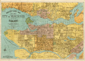
Indexed guide map of the City of Vancouver and suburbs

A few facts about the north Fraser River

Transit system map of Greater Vancouver, B.C.

Inset maps and indexes

Front page and index map

The service route to - from - through industrial southwestern British Columbia

Plan of the City of Vancouver

Plan of the City of Vancouver

Visit the souvenir shop

Tourist map of Greater Vancouver

Map of Vancouver, British Columbia

Street index
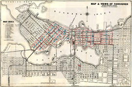
Map and views of Vancouver, British Columbia, Canada
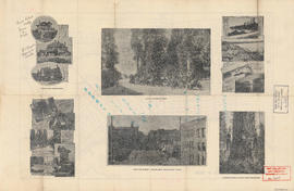
Views of Vancouver

Map and views of the terminal city, Vancouver, British Columbia, Canada : map cover

Map and views of the terminal city, Vancouver, British Columbia, Canada : inside map cover

City of Vancouver, British Columbia : zoning diagram