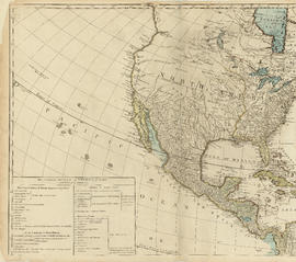
- AM1594-: MAP 855-: LEG1153.133
- Part
- [ca. 1785]
Part of City of Vancouver Archives technical and cartographic drawing collection
Part is the top left hand quadrant of a map of the Americas, and depicts North America and the north-west portion of South America. The sheet also includes a list of territories and islands in North America and appears to relate to territorial divisions as a result of the Treaty of Paris and the Treaty of Versailles (1783).


![Hastings Townsite [Boundary Road to 5th Avenue to Kamloops Street (?) to 33rd Avenue]](/uploads/r/null/7/f/0/7f0fe2a27b9af4f20ad7837792af3bbb3aa93c3487024e69b14fa38144134f19/8e7a0e66-c6cc-40ca-bbac-4ea73db77437-LEG1800_142.jpg)
![Hastings Townsite [Boundary Road to English Bay to Commercial Drive to Charles Street]](/uploads/r/null/f/f/f/fff4026408c5cdfe071e2699b8a35b248daec6b4d059622bf14a49b96a15fb3c/a21002e4-eead-4468-b03a-a44b355308fa-LEG1800_142.jpg)