Showing 1194 results

Archival description
City of Vancouver Archives technical and cartographic drawing collection Item With digital objects
Print preview View:

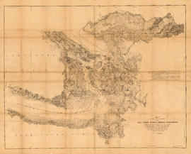
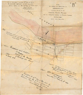
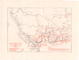
Plan of a portion of the water front of Vancouver city

Item is a tracing of a map showing the Vancouver waterfront between Granville and Carrall streets. The original map contains a number of attestations which have been traced: by W.C. Van Horne (Mar. 11, 1886); H.J. Cambie, Engineer in charge (Feb. 22, 1886); T. Trudeau, Deputy Minister of Railways (31 Mar. 1886); and Land Registry office (12 May 1886). The Tracing was made from a copy submitted as an appendix to an affadvit May 28, 1891.
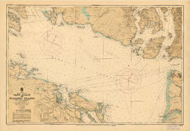
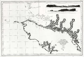
Plan 3

Map shows present and proposed roads of the Lower Mainland and northern Washington State, as well as road repairs. Map covers the area from Point Grey to Hope and from Burrard Inlet to Bellingham Bay. Trails and roads indicated on the map include Telegraph Trail, Waggon Road and Pitt River Waggon Road, as well as several unnamed trails. Major bodies of water indicated on the map are Burrard Inlet, False Creek, Burnaby Lake, Pitt River, Fraser River, Sumas Lake, Sumas River, Chulukweyuk River, Harrison River, Boundary Bay, Semiahmoo Bay and Bellingham Bay. Place names are indicated throughout the map. 11T3 Roads & Trails is printed on the side of the map.

Town-site of Hastings

Map shows Hastings Town-site, Granville Town-site, Burnaby, and the City of New Westminster. Map also shows the Road from Granville and the False Creek Trail, as well as the names of places and soil types found along these roads. Other places and structures noted include Burrard Inlet, Coal Harbour (Coal Harbor on map), False Creek, False Creek Bridge, Burnaby Lake, Fraser River, New Westminster and Burrard Inlet Road, Douglas Road, Edinburgh Street, Columbia Street, Richards Street, and the New Westminster Cemetery. Two notes on map read "Plan to accompany Report of 1st May 1883, Joseph Hunter" and "Memo: Mr. Ross will place [?] this map to the [Engs.] Office Victoria [?]." 14T3 Roads & Trails is printed on the side of the map.

Unemployment relief works under Department of National Defence, Canada : British Columbia and Alberta

Item is a map showing the locations of and details associated with unemployment relief works projects in British Columbia and western Alberta. An inset map shows the Peace River highways. The location of projects, project number, and information of staffing numbers, accommodation and in some cases man-days of the project are noted.

Vancouver Harbour, British Columbia

Item is a map adhered inside a leather presentation case made for Lord Tweedsmuir by the Vancouver Harbour Commissioners. The item was presented to Lord Tweedsmuir during a visit to Vancouver in 1936. Accompanying the map there is a booklet by the Vancouver Harbour Commissioners entitled "Interesting Facts about the Port of Vancouver" and a note to Henry "Budge" Bell-Irving from John Tweedsmuir. The map shows English Bay and Burrard Inlet with soundings in feet. Map shows district lots and street names from Lighthouse Park and the University of British Columbia to the border of the Municipality of Coquitlam. Includes inset maps of North Arm Burrard Inlet and Vancouver Island.

Sketch of the upper part of the Fraser River from Langley to Yale

Item is a modern reproduction of an Admiralty map showing landmarks, geographic features and First Nations settlements along the upper part of the Fraser River from Langley to Yale. The map includes five illustrations of various locations along the river, which correspond to locations noted on the map. The illustrations are labeled: View A - Fort Yale, View B - Emery Bar, View C - Mouth of the Quequealla (Coquihalla River?), View D - Cornish Bar and View M - Entrance of river, Mount Blanchard in the distance.

United Kingdom. Admiralty

Plan of sub-division of lot 2027, group 1, New Westminster District, B.C., to be sold by public auction at Vancouver, B.C.

Item is a map showing major streets, lot numbers, lot boundaries and property sold or reserved in the area from Chaldecott Road (now King Edward Ave.) in the north to Magee Road (now W. 49th Ave.) in the south. Kaye Road (now Trafalgar St.), Wilson Road (now W. 41 Ave.), Bodwell Road (now W. 33rd Ave.) and Johnson Road (now Blenheim) are all included on the map.

Plan of provincial government property being a portion of townsite of Vancouver and sub-division of lot 540, group 1, New Westminster District, B.C., to be sold by public auction at Vancouver, B.C.

Item is a map showing lot numbers, lot boundaries, major streets and property sold or reserved in the area bounded by Campbell Street (Alma Street), present-day Trafalgar Street (unnamed on map), English Bay, and 16th Avenue.

Pictorial map of Greater Vancouver showing dates of settlement in specific areas and opening dates of regional landmarks

Item consists of an illustrated map of the Vancouver area and an overlay showing dates of settlement in various areas and the opening dates of regional landmarks. A poem about the growth of Vancouver has been included on the right-hand side of the map. Verso contains a seemingly unrelated drawing dated 1911 and showing front and side elevations for a church building.

Vancouver sheet, British Columbia

Item is a map of Vancouver Island and the southwest portion of mainland British Columbia from Bella Coola to Clinton, and south to New Westminster. Map shows geological, land district, and park boundaries; locations of mining recording offices and sub-offices; elevations in feet above sea level; mineral occurrences; and the development of geological formations by era.

Plan of Greater Vancouver, British Columbia

Item is a map of Greater Vancouver from Alma Road (Alma Street) to Boundary Road and Burrard Inlet to King Edward Avenue. Map shows district lot, block, and lot numbers, waterfront businesses, rail lines, schools, parks, beaches, and concentric circles indicating distances from a point located approximately at the intersection of Cambie and Hastings Streets.

Map showing the line of boundary between the United States and British possessions

Item is a map showing four proposed boundaries between the United States and British possessions in the Salish Sea region. The explanations of the lines read in part: "[1] Boundary line contemplated by the Treaty as shown by contemporaneous evidence; [2] Boundary line as claimed by the British Commissioner; [3] Boundary line proposed by the British Commissioner as a compromise ( . . . ); [4] Boundary line in accordance with the strict letter of the Treaty ( . . . ). Item also shows soundings, and the "track of steamers plying between Victoria and Fraser river since discovery of gold."

British Columbia

Item is a modern photocopy of a map showing the southwest portion of British Columbia and the northwest part of Washington State. The map depicts settlements, geographical features, wagon roads, bridle paths and other man-made features. Prepared under the direction of Capt. Persona, R.E. by order of Col. R.C. Moody, R.E.

Plan of a 9.783 acre portion of Kitsilano Indian Reserve, District Lot 3610, Group one, New Westminster District [annotated]

Item is a map depicting the area of the former Department of National Defence site at Kitsilano Point (now part of Vanier Park). The map shows the locations of the various Defence buildings on the site. Annotations depict what appears to be draft layout of the Museum of Vancouver and Planetarium buildings superimposed on the site.

Vancouver (B.C.). Office of the City Engineer

Plan of a 9.783 acre portion of Kitsilano Indian Reserve, District Lot 3610, Group one, New Westminster District [annotated]

Item is a map depicting the area of the former Department of National Defence site at Kitsilano Point (now part of Vanier Park). The map shows the locations of the various Defence buildings on the site. Annotations show a grid layout imposed on the site.

Vancouver (B.C.). Office of the City Engineer

Plan of a 9.783 acre portion of Kitsilano Indian Reserve, District Lot 3610, Group one, New Westminster District [annotated]

Item is a map depicting the area of the former Department of National Defence site at Kitsilano Point (now part of Vanier Park). The map shows the locations of the various Defence buildings on the site. Annotations show measurements on the north-west boundary of the site.

Vancouver (B.C.). Office of the City Engineer

A map of the whole continent of America divided into North and South and West Indies

Item is a reproduction of a map which depicts North America, South America and the West Indies. An inset map on the lower left-hand corner shows Baffin Island and Hudson's Bay. The item also includes lists of islands and regions in the Americas belonging to each of Great Britain, France, Spain, Portugal, Denmark and the Dutch, as per the terms of the Treaty of Paris. The item also includes a list of nine relevant articles defined in the 1763 Paris treaty.

Carta esferica de los reconocimientos hechos en la costa No. de America des de la parte en que empiezan a angoftar de Juan de Fuca hafta la salidade las Goletas Sutil y Mexicana

Item is a reproduction of a map depicting the Spanish explorations of the north-west coast of North American in 1795, specifically depicting the northern end of Vancouver Island and the adjacent mainland. Illustrations are views of the entrance to Nootka Sound, and a view of "Cabo Frondoso" (Cape Cook?).

Results 1 to 50 of 1194