
City of Vancouver : 1986 census of Canada
- PUB-: PD 2109b
- Item
- 1986
Part of City publications collection
Item is a map showing 1986 census tracts and enumeration areas, and federal electoral districts.
City of Vancouver : 1986 census of Canada
Part of City publications collection
Item is a map showing 1986 census tracts and enumeration areas, and federal electoral districts.

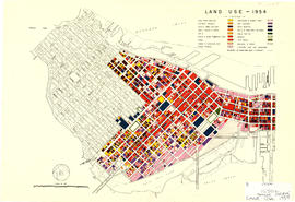
City of Vancouver : land use 1984
Part of City publications collection
Item is a map showing types of residential, commercial, industrial, and recreational land use in Vancouver.
Part of City publications collection
Item is a map showing streets, address block numbers, parks, schools, golf courses, First Nations reserves, railways, and topographic contour lines.

City of Vancouver, B.C. : curb ramp locations
Part of City publications collection

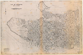
City of Vancouver, British Columbia : 1981 census of Canada
Part of City publications collection
Item is a map showing 1981 census tracts and enumeration areas, and federal electoral districts.

Commodities shipped overseas through Port of Vancouver
Part of City publications collection
Item is a page with charts depicting growth of tonnage imported between 1921 and 1926 for commodities such as lumber, apples, etc.

Part of City publications collection
Item is a map showing streets, building footprints and number of storeys.

Downtown peninsula - Vancouver, B.C. : contour lines at 10 foot intervals, datum line - 100
Part of City publications collection

Part of City publications collection

Greater Vancouver British Columbia Railroads and Harbour
Part of City publications collection

Part of City publications collection
Part of City publications collection
Item is a map showing land use for single family, two family. and multiple family dwellings, tourist courts and cabins, hotels, offices and other commercial uses, stores, parking and commercial lots, service stations, warehouses and storage yards, light industrial, heavy industrial, public and semi-public buildings, public utilities, schools, open spaces, and railroads and docks.

Map of City of Vancouver showing schools, parks, community centres, libraries, health units
Part of City publications collection
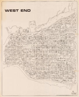
Item is a map designed to be folded into a pamphlet. Pamphlet covers (on verso of map) give map title and credit the City of Vancouver as publisher of the map.

Part of City publications collection
Item is a map showing proposed commercial and residential zones and the location of an elementary school in the area directly south of Simon Fraser University. Base map shows land use for the area bounded by Willingdon Avenue, North Road, Barnet Road, and the Trans-Canada Highway.

Official Regional Plan : proposed amendments within the City of Vancouver
Part of City publications collection
Item is a map showing proposed amendments to industrial and rural zoning areas.

Port of Vancouver water-borne exports
Part of City publications collection
Item is a page with 4 charts depicting growth of tonnage exported between 1921 and 1926.

Port of Vancouver water-borne imports
Part of City publications collection
Item is a page with 4 charts depicting growth of tonnage imported between 1921 and 1926.

Preliminary report on civic centre
Part of City publications collection

Present use. Vancouver harbour
Part of City publications collection

Proposed development of waterfront. South shore Burrard Inlet
Part of City publications collection
Item is a page with 3 charts depicting growth of waterfront development.

Proposed elevated waterfront roadway
Part of City publications collection
Item is a sheet with a map depicting the site plan of a proposed elevated roadway along the shoreline of the south shore of Burrard Inlet, as well as section and elevation drawings.
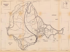
Part of City publications collection
Item is a map showing roads, trails, walkways, parking lots, buildings, shorelines, creeks, and swamps in Stanley Park.

Vancouver harbour potential wharfage and trackage areas
Part of City publications collection
Part of City publications collection
Item is a map showing streets, building footprints, number of storeys, topographic contour lines, and street codes according to a system adopted by the Engineering Department in the mid-1960s.

Part of City publications collection
Item is a map showing streets, building footprints and number of storeys.

Part of City publications collection
Item is a map showing streets, building footprints, number of storeys, and street codes according to a system adopted by the Engineering Department in the mid-1960s.

Zoning District Plan : City of Vancouver, British Columbia
Part of City publications collection
Item is a zoning map showing different zoning districts of Vancouver in 1976.

Zoning map : City of Vancouver, British Columbia
Part of City publications collection
Item is a zoning map showing different zoning districts of Vancouver in 1990. A brief description of the zoning map districts is shown on the reverse side of the map.

Zoning map : City of Vancouver, British Columbia
Part of City publications collection
Item is a zoning map showing different zoning districts of Vancouver in 2001.

Zoning Map: City of Vancouver, British Columbia
Part of City publications collection
Item is a zoning map showing different zoning districts of Vancouver in 1974. Map has a plastic overlay shows local areas.

Zoning Map: City of Vancouver, British Columbia
Part of City publications collection
Item is a zoning map showing different zoning districts of Vancouver in 1963.

Zoning Map: City of Vancouver, British Columbia
Part of City publications collection
Item is a zoning map showing different zoning districts of Vancouver in 1969.

Zoning Map: City of Vancouver, British Columbia
Part of City publications collection
Item is a zoning map showing different zoning districts of Vancouver in 1960.