Plan of a portion of the water front of Vancouver city
Plan of part of West Vancouver District
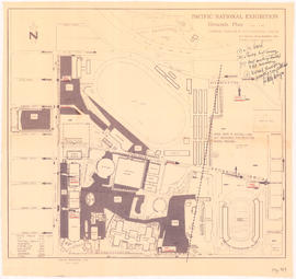
Pacific National Exhibition grounds plan
Plan 3
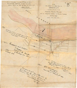
Town-site of Hastings
Pacific National Exhibition grounds plan : parking available for proposed arena
General development plan, Exhibition Park, Vancouver, B.C.
Vancouver sewers
A preliminary proposal for development of Jericho Park
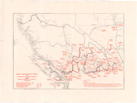
Unemployment relief works under Department of National Defence, Canada : British Columbia and Alberta
Vancouver Harbour, British Columbia
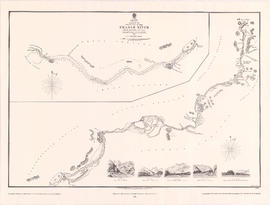
Sketch of the upper part of the Fraser River from Langley to Yale
Plan of provincial government property being a sub-division of a portion of expired timber lease situated in North Vancouver, New Westminster district, B.C., to be sold by public auction
Plan of sub-division of lot 2027, group 1, New Westminster District, B.C., to be sold by public auction at Vancouver, B.C.
Plan of provincial government property being a portion of townsite of Vancouver and sub-division of lot 540, group 1, New Westminster District, B.C., to be sold by public auction at Vancouver, B.C.
Plan of part of sub-division of district lot 540, South Vancouver, provincial government property
Plan of the municipality of South Vancouver
Pictorial map of Greater Vancouver showing dates of settlement in specific areas and opening dates of regional landmarks
Vancouver sheet, British Columbia
Plan of Greater Vancouver, British Columbia
Map and guide of Greater Vancouver
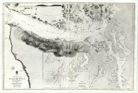
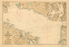
Sand Heads to Ballenas Islands
[Cross sections of ocean floor between Vancouver Island and mainland of British Columbia]
Map showing the line of boundary between the United States and British possessions
British Columbia
British North America
Plan no. 2 : showing city distribution system, pressure districts, fire stations and water flow test locations : City of Vancouver, British Columbia
Coal Harbour, Vancouver, B.C.
Plan of a 9.783 acre portion of Kitsilano Indian Reserve, District Lot 3610, Group one, New Westminster District [annotated]
Plan of a 9.783 acre portion of Kitsilano Indian Reserve, District Lot 3610, Group one, New Westminster District [annotated]
Plan of a 9.783 acre portion of Kitsilano Indian Reserve, District Lot 3610, Group one, New Westminster District [annotated]
Plan of a 9.783 acre portion of Kitsilano Indian Reserve, District Lot 3610, Group one, New Westminster District
Plan of Lot 6311, Vancouver, B.C. fronting on Kitsilano Indian Reserve No. 6
Plan of the City of Vancouver. Western Terminus of the Canadian Pacific Railway
Map of early Chilliwack district
The asiatic part of the Russian empire
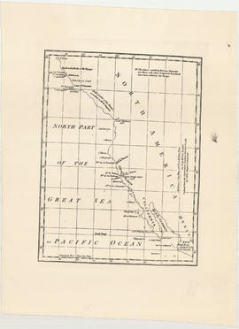
North part of the great sea, Pacific Ocean
A portion of a map showing the coasts of Peru and Chile
Nova totius terrarum orbis geographica ac hydrographica tabula
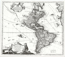
A map of the whole continent of America divided into North and South and West Indies
Totius Americae
Chart von America
Algemeene kaart : van de ontdekkingen van Kapit. J. Cook
Nova totius Americae descriptio
Kaart van de noord-west kust van Amerika en de noord-oost kust van Asia
Strait of Juan de Fuca
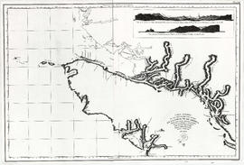
Cape Caution to Port Simpson including Hecate Strait and part of Queen Charlotte Islands
Haro Strait and middle channel
Vancouver Island and adjacent shores of British Columbia
Carta esferica de los reconocimientos hechos en la costa No. de America des de la parte en que empiezan a angoftar de Juan de Fuca hafta la salidade las Goletas Sutil y Mexicana


![[Cross sections of ocean floor between Vancouver Island and mainland of British Columbia]](/uploads/r/null/c/a/6/ca687b43e46696a0c1d9223ef1e80ebe50bba0ea48092c458b525fc90f7b517c/7d458083-64ae-4682-be03-8fd1211e38c9-MAP8b_142.jpg)