
A drive around the park, Stanley Park Stables, a typical party in 1901
- AM977-: CVA 319-06
- Item
- 1901
Part of Mitchell family fonds
A drive around the park, Stanley Park Stables, a typical party in 1901
Part of Mitchell family fonds

Part of William Orson Banfield fonds
![[Aerial view of Stanley Park from downtown, 1 of 2]](/uploads/r/null/e/a/2/ea2fa7aeab8d090954336d4db69c725ba8abe57666d3be52009dbd001144c31e/c53aa37e-5123-4247-bfcf-31b31651977f-CVA1095-07042_142.jpg)
[Aerial view of Stanley Park from downtown, 1 of 2]
Part of City of Vancouver fonds
![[Aerial view of Stanley Park from downtown, 2 of 2]](/uploads/r/null/8/d/f/8dfcdae0f34fc74635d4083942eb671c0ef2a5ac52c683008bafec1a8ee3e3ec/c8facdb8-84fd-459b-935a-f90e79b7a972-CVA1095-07043_142.jpg)
[Aerial view of Stanley Park from downtown, 2 of 2]
Part of City of Vancouver fonds
![[Arch at entrance to Stanley Park]](/uploads/r/null/1/3/131bc813b53c435c26b494c0e2e1587b7842afdcc77d58c199c753065c5c9b9e/40346c2d-01f6-475b-98af-cc918d7442bc-A08357_142.jpg)
[Arch at entrance to Stanley Park]
Part of Major Matthews collection
Photograph shows a man standing under the arch in front of the bridge into Stanley Park.
![[Arch at entrance to Stanley Park]](/uploads/r/null/5/0/509bcab6a15d1cdd4cb67722e008d6b74106daf2c050ce28008e9a7e7631a6ed/879f45a1-17ee-4bfe-979a-a99c52c9cd8e-A36752_142.jpg)
[Arch at entrance to Stanley Park]
Part of Major Matthews collection
Photograph shows a man standing under the arch in front of the bridge into Stanley Park.

Autumn in Stanley Park, Vancouver, B.C.
Part of Major Matthews collection
Photograph shows three men in a carriage on a dirt road surrounded by trees and bush. J.S. Matthews' notes with print or negative in Archives.

Part of James Crookall fonds

Bleachers and goal posts on field at Stanley Park

Brockton Point - Stanley Park - Vancouver, B.C.
Part of George Thompson fonds
![[Brockton Point, part of village in Stanley Park, viewed from Burrard Inlet]](/uploads/r/null/e/0/e01326d91bf7be41525b652a17f95813db39bfd8f1a61dd0aba89ba2542c5617/c975de0b-8d0f-428f-b17b-51b9abb18afb-A04010_142.jpg)
[Brockton Point, part of village in Stanley Park, viewed from Burrard Inlet]
Part of Major Matthews collection
J.S. Matthews' notes with print or negative in Archives.


Part of Major Matthews collection
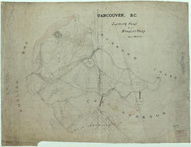
Part of City of Vancouver fonds
Item is a topographical map of Stanley Park showing various landmarks and locations of buildings.
Vancouver (B.C.). Engineer's Office
![[Couple walking along sea wall at] Hallelujah Point](/uploads/r/null/9/2/9/9297a0611cf9a6f1d763d28b61460aa1cfa806d6e68f170197138ced4cd7f9e1/54596040-a08e-4107-bd36-7d86fa22c7e4-CVA293-024_142.jpg)
[Couple walking along sea wall at] Hallelujah Point
![[Couple walking along sea wall at] Hallelujah Point](/uploads/r/null/d/9/1/d914e2b2e6ed885b0ccb7f88353d93c3c8795b479701b36ba8fdd15814c55273/00ef84c0-9812-4b3f-adb0-29df241bddba-CVA293-024_142.jpg)
[Couple walking along sea wall at] Hallelujah Point

Drive at Brockton Point, Vancouver, B.C.
Part of Major Matthews collection
J.S. Matthews' notes with print or negative in Archives.


Photograph shows building and bridge

Entrance to Stanley Park - Vancouver, B.C.
Part of George Thompson fonds
![Entrance to Stanley Park [from above]](/uploads/r/null/f/4/e/f4e909af0fe287a6195b2388036e4f016ab747391c3ae98e26642465908f5975/66ed01b0-0e9f-4951-a59e-eea2b423033c-CVA294-087_142.jpg)
Entrance to Stanley Park [from above]
Part of Bertram Emery fonds
![[Family assembled on rock near road in Stanley Park]](/uploads/r/null/8/9/8914c49e2fceccc98b108f67b279ccc659ceaae8d7cbdddeed75a302a11b97f9/e655abfd-ad9f-4feb-9348-21964cba3e18-A04019_142.jpg)
[Family assembled on rock near road in Stanley Park]
Part of Major Matthews collection
![[Family in horse drawn carriage at Stanley Park]](/uploads/r/null/0/6/06c1e5e35b964b9f95f328c3b2a4731cf5f2c0c2b72612c74bbbf2aa3cdb33be/da30dd89-7190-4819-8edc-153bd2c1ac82-A04020_142.jpg)
[Family in horse drawn carriage at Stanley Park]
Part of Major Matthews collection
J.S. Matthews' notes with print or negative in Archives.
![Ferguson Point Tea House [at Stanley Park]](/uploads/r/null/c/2/c2c6330864dca9869e9efa4d567e3a7bd0f62399f0554151079563dd58be4f56/5178db50-19f1-4141-b72a-5b06e1d8d20e-A59807_142.jpg)
Ferguson Point Tea House [at Stanley Park]
Part of City of Vancouver fonds


Gardens - Canada : Prunus Akebono, Stanley Park

Gardens - Canada : Stanley Park

Gardens - Canada : Stanley Park

Gardens - Canada : Stanley Park seawall

Group installing event tent in front of totem poles

Group installing event tent in front of totem poles

Group walking across field in front of totem poles at Stanley Park

Groups assembled around totem poles

Groups assembled around totem poles
![[Harding Memorial, Stanley Park]](/uploads/r/null/f/8/2/f82485a469b15179812e50424e6eda085a5f90eb5f8ef9b5e22a37f352de0418/5f425633-13c4-4cf6-a551-0a3ed5870613-CVA1095-00030_142.jpg)
[Harding Memorial, Stanley Park]
Part of City of Vancouver fonds
![[HMS Egeria plaque]](/uploads/r/null/d/2/0/d2056c0dae8264076fbe68bb66478cab784b11b94440906aa1f6636b16478ead/52f19f3e-b5a8-4e1f-b499-7680c1db4e0d-CVA1095-00038_142.jpg)
Part of City of Vancouver fonds
Image is a photograph that depicts a detail of the HMS Egeria plaque. It contains the following inscription: "This concrete slab was set by the Royal engineers in 1865 and was used as a survey point in 1898 by the Royal Navy ship H.M.S. Egeria."

![[Island in lake, Stanley Park]](/uploads/r/null/f/4/f4d03a172f03857093502f4e38e059e76506cadffcbbb9111d36d92acbc39ea5/e1739b94-63f7-41ca-9414-f94a792179aa-A20570_142.jpg)
[Island in lake, Stanley Park]
Part of James Luke Quiney fonds

Japanese cherry trees, Stanley Park; 1950
Item is a photograph of Japanese cherry trees in bloom around the Japanese Memorial in Stanley Park.
![[Kiwanis Club Rose Plot, Stanley Park]](/uploads/r/null/a/f/9/af908b453eee8919bb81279067496a762dae178523ce1dd5410cff21b7a32be4/52e40ab0-8502-4319-a228-6af892ec878e-CVA1095-00033_142.jpg)
[Kiwanis Club Rose Plot, Stanley Park]
Part of City of Vancouver fonds
Item is a photograph of a dedication stone with the inscription: "Kiwanis Club Rose Plot First planted in 1920 to demonstrate the possibilities of rose culture in Vancouver. 'The City Beautiful.'"
![[Logging skid trail in Stanley Park]](/uploads/r/null/c/8/c85475e830cbbc0ebe0a968b70a19732b55884211ee1afd17251089afb598512/c3018567-504e-44ab-9e6c-57be58d7bd4f-A32019_142.jpg)
[Logging skid trail in Stanley Park]
Part of Major Matthews collection

Looking over Brockton Point in Stanley Park, from C.P.R. Hotel Vancouver, B.C.
Part of William Orson Banfield fonds
![[Malkin Bowl, Stanley Park]](/uploads/r/null/f/0/6/f06072f2697f6cb7cd0ddd8979712656de86fcf0823ed21863b9aa442a69b259/56254988-56c2-4e55-9772-d4fb1b228ff1-CVA1095-00029_142.jpg)
Part of City of Vancouver fonds
![Map of Stanley Park [site plan]](/uploads/r/null/1/c/1c9f6dc06e0884db9e77fbf60ada5f034a83d9de980993fddeb5e2475c9e2b97/52d1c868-f7bb-48bd-a2e8-0fa3444cfeec-MAP62_142.jpg)
Map of Stanley Park [site plan]
Part of City of Vancouver Archives technical and cartographic drawing collection
Item is a copy of a published map of Stanley Park which has been annotated to show proposed redevelopment plan for the western portion of Coal Harbour (currently Lost Lagoon) and surrounding area. It is believed that this is one of the sheets referred to by Thomas Mawson in his report to the Board of Parks Commissioners regarding various proposed development schemes for the entrance to Stanley Park and the Coal Harbour area.

Marine Drive, Stanley Park, Totem pole : Scenics Vancouver
Mrs. McCulloch, Vancouver park
![[Nine] O'Clock Gun [at Stanley Park]](/uploads/r/null/9/b/9bced4048b1ed00d017b8ce0677dfb3d28c18145250e02b5c6968cec3f310c62/b86fc513-c49f-444e-b809-079956496a48-A59809_142.jpg)
[Nine] O'Clock Gun [at Stanley Park]
Part of City of Vancouver fonds
![[Open horse drawn carriage, travelling along scenic road in] Stanley Park](/uploads/r/null/d/8/5/d85a923aa0f80b8c301b29795ced370847dc85c32cab99758c158b7092fae73c/b32c95f5-3745-4cea-8f1d-7f94d357d52b-CVA220-15_142.jpg)
[Open horse drawn carriage, travelling along scenic road in] Stanley Park