![[Firefighters and motorized equipment in front of Firehall No. 2, 754 Seymour Street]](/uploads/r/null/1/a/2/1a2f1373f1d648856294c4009aca38f93d121927679c379a3ab4dd4db0fd8128/e7169b57-02b8-4cc5-a5d8-122e1c212954-CVA354-043_142.jpg)
[Firefighters and motorized equipment in front of Firehall No. 2, 754 Seymour Street]
- COV-S280-: CVA 354-043
- Item
- [ca. 1915]
Part of City of Vancouver fonds
4431 results with digital objects Show results with digital objects
[Firefighters and motorized equipment in front of Firehall No. 2, 754 Seymour Street]
Part of City of Vancouver fonds
![[No. 6 La France hose wagon rammed against tree following accident at Pender and Burrard Streets]](/uploads/r/null/5/0/2/502023e0a13c58e7d816b556ebf58fb12dc828e86d535dc7450e4c1236d2fe14/e1bc9b81-72d6-4074-a76a-ba9e61cca2ac-CVA354-044_142.jpg)
[No. 6 La France hose wagon rammed against tree following accident at Pender and Burrard Streets]
Part of City of Vancouver fonds
Item is a photograph showing the engine stuck in the tree and a small group gathered around the accident site. Inscription on verso states "A few minutes before midnight this #6 Lafrance Hosewagon which collided with #6 Seagrave Chemical".
![[Gathering of fire engines to show "Fully Motorized" occasion at C.P.R. freight yards]](/uploads/r/null/4/6/4/464e3333148bebd4439aa317794f2892018b4cdc4c4f2c3e8cfed544422a76d1/ac7aecd4-f952-4786-9697-0f24efacfc7c-CVA354-049_142.jpg)
[Gathering of fire engines to show "Fully Motorized" occasion at C.P.R. freight yards]
Part of City of Vancouver fonds
Item is a photograph showing firefighters and fire equipment with a view of the 700 block of Main Street and a rail car in the background.
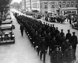
![[Firefighters and equipment assembled in front of Firehall No. 2, Seymour Street]](/uploads/r/null/e/c/9/ec99f99730399ff2867febe28c8d8486234f3580f882388b74d21a8437aee50b/a286e792-0d1f-4477-a0ce-ce3721f8ceb5-CVA354-051_142.jpg)
[Firefighters and equipment assembled in front of Firehall No. 2, Seymour Street]
Part of City of Vancouver fonds

Part of City of Vancouver fonds


Part of City of Vancouver fonds

Part of City of Vancouver fonds

Part of City of Vancouver fonds

Part of City of Vancouver fonds
Part of City of Vancouver fonds

Part of City of Vancouver fonds
Part of City of Vancouver fonds

Part of City of Vancouver fonds
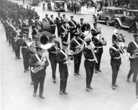
![[Group portrait of Firemen's Band on steps of Vancouver Court House]](/uploads/r/null/6/7/1/671ad823231c96cc5d64acf1461780da510a44b5779df01a4f7d6f2afba9aee6/28cbea32-cd96-49d3-8b15-a1440201704f-CVA354-101_142.jpg)
[Group portrait of Firemen's Band on steps of Vancouver Court House]
Part of City of Vancouver fonds
Part of City of Vancouver fonds
![8:06 pm Monday Dec. 26/55 1131 Beach Ave [view of firefighters putting out house fire]](/uploads/r/null/c/a/a/caa5f06f73ca6df11bac94ba2d2769850d20b0eb132ab978c475a65159c47fd3/17b3b295-3ccf-44d6-b9fb-6edd53c78e44-CVA354-163_142.jpg)
8:06 pm Monday Dec. 26/55 1131 Beach Ave [view of firefighters putting out house fire]
Part of City of Vancouver fonds
![8:06 pm Monday Dec. 26/55 1131 Beach Ave [view of firefighters putting out house fire]](/uploads/r/null/6/a/1/6a12647ac0f56355d27068df38766b24072ec21727a47cb1720c0a4776f47b18/e674c369-21ab-43ea-b482-8ebef2f0b301-CVA354-164_142.jpg)
8:06 pm Monday Dec. 26/55 1131 Beach Ave [view of firefighters putting out house fire]
Part of City of Vancouver fonds
![8:06 pm Monday Dec. 26/55 1131 Beach Ave [view of firefighters putting out house fire]](/uploads/r/null/5/5/e/55e6e5ee078efef5b8db66756db934b5a8e587d96615b516795cef0686bee29f/c1d72d91-cf49-4366-baf1-ce1807a52e46-CVA354-165_142.jpg)
8:06 pm Monday Dec. 26/55 1131 Beach Ave [view of firefighters putting out house fire]
Part of City of Vancouver fonds
![8:06 pm Monday Dec. 26/55 1131 Beach Ave [view of firefighters putting out house fire]](/uploads/r/null/2/5/3/25343a0e40da6feefe9d0a9cc2d574f77a399b538e008d943a17a8abad426e4c/9757c2d3-cdc0-4d2e-9c73-a6eb390a27ac-CVA354-166_142.jpg)
8:06 pm Monday Dec. 26/55 1131 Beach Ave [view of firefighters putting out house fire]
Part of City of Vancouver fonds
![[Firefighters removing body of suicide victim from marquee of Georgia Hotel]](/uploads/r/null/7/f/b/7fb1c694b66ddd4ef6e5a8cb68817475d2d5efcc733c4eb62c2fcda0dba871c8/e6ddfc41-d1fb-49ef-a336-489cab29ed27-CVA354-171_142.jpg)
[Firefighters removing body of suicide victim from marquee of Georgia Hotel]
Part of City of Vancouver fonds
![[View of new fire engines parked in front of Firehall No. 1, West Georgia at Hamilton]](/uploads/r/null/f/d/fd79a139fd0b50167cb4c48ec50d0cb38f48d9c3a387d325aa232940c6b6de8a/17bbadfb-d23c-410a-b06b-0efcf6db159d-A43354_142.jpg)
[View of new fire engines parked in front of Firehall No. 1, West Georgia at Hamilton]
Part of City of Vancouver fonds
Item is a photograph showing (L-R): Larry Holden (A/Chief), Chief Bird, and Elmer Sly (Dept. Chief) standing in front of engines and the Canada Post building is the background.
![[Chief C.W. Thompson seated in Vancouver Fire Department automobile by Court House]](/uploads/r/null/9/5/7/957086fef640611a76ba82f9d85c3c033e0817a97acff07df0202d93930b6df9/d8263eca-24ec-48ab-bd53-3871f1b75d1d-CVA354-389_142.jpg)
[Chief C.W. Thompson seated in Vancouver Fire Department automobile by Court House]
Part of City of Vancouver fonds
![[Funeral procession of firefighter Don McCavour on Burrard Street, near Georgia]](/uploads/r/null/4/e/4/4e4a21a8c2f131ddf74afb6737b3565de0f911f94e51292886345c1c68f05f0e/75c62110-7203-4ba9-af74-31c850715ca4-CVA354-423_142.jpg)
[Funeral procession of firefighter Don McCavour on Burrard Street, near Georgia]
Part of City of Vancouver fonds

Plan of proposed public convenience, Georgia & Granville Sts., Vancouver, B.C.
Part of City of Vancouver fonds
Item is an architectural drawing of a public toilet and includes a floor plan, longitudinal section, and location plan.
Vancouver (B.C.). Engineer's Office

Topographic map of Downtown Vancouver and the East End
Part of City of Vancouver fonds
Item is a map showing two sets of topographic contour lines, streets, and block numbers (in Roman numerals) in the area from Robson Street to Raymur Avenue and Coal Harbour/Vancouver Harbour to False Creek.

Value of land (1954 assessment)
Part of City of Vancouver fonds
Item is a map showing land values in dollars per square foot for the downtown area bounded by Burrard Street, Robson Street, and Nicola Street in the west and Main Street in the east.

Building permit values for stores, 1945-1954
Part of City of Vancouver fonds
Item is a map showing building permit values for stores in dollars per square foot for the downtown area bounded by Burrard Street, Robson Street, and Nicola Street in the west and Main Street in the east.

Building permit values for offices, 1945-1954
Part of City of Vancouver fonds
Item is a map showing building permit values for offices in dollars per square foot for the downtown area bounded by Burrard Street, Robson Street, and Nicola Street in the west and Main Street in the east.

Part of City of Vancouver fonds
Item is a map showing potential redevelopment areas based on exisitng density, suitability for parking structures, and suitability for comprehensive redevelopment. Map covers the downtown area bounded by Burrard Street, Robson Street, and Nicola Street in the west and Main Street in the east.

Proposed customer parking areas
Part of City of Vancouver fonds
Item is a map showing proposed parking areas and the high density core area in downtown Vancouver from Burrard Street, Robson Street, and Nicola Street in the west to Main Street in the east.

Part of City of Vancouver fonds
Item is a map showing proposed commercial and industrial zoning at high and medium densities, and the boundaries of the proposed high density core and parking areas in downtown from Burrard Street, Robson Street, and Nicola Street in the west to Main Street in the east.

Part of City of Vancouver fonds
Item is a map showing pedestrian traffic volumes by people per linear foot of street for the downtown area bounded by Burrard Street, Robson Street, and Nicola Street in the west and Main Street in the east.

Part of City of Vancouver fonds
Item is a map showing building density by floor space ratio for the downtown area bounded by Burrard Street, Robson Street, and Nicola Street in the west and Main Street in the east.

Part of City of Vancouver fonds
Item is a map showing office density by floor space ratio for the downtown area bounded by Burrard Street, Robson Street, and Nicola Street in the west and Main Street in the east.

Part of City of Vancouver fonds
Item is a map showing retail store density by floor space ratio for the downtown area bounded by Burrard Street, Robson Street, and Nicola Street in the west and Main Street in the east.

Possible civic square development for downtown Vancouver
Part of City of Vancouver fonds
Item is a drawing showing existing civic structures, possible new structures, and a proposed civic square.

Rail car and bus routes as at April 1953
Part of City of Vancouver fonds
Item is a map showing rail car and bus routes for the downtown core of Vancouver from Burrard Street to Main Street.

Trolley coach routes as at April 1953
Part of City of Vancouver fonds
Item is a map showing trolley coach routes for the downtown core of Vancouver from Burrard Street to Main Street.
![C.B.D. [Central Business District] trip trace density chart](/uploads/r/null/6/b/4/6b4dfcd5710a8add68045b374b1df6e0649e8577a53d23070c9494276c76c3fd/0e0776f3-ca72-4c99-8121-6e7293b90cee-LEG26_142.jpg)
C.B.D. [Central Business District] trip trace density chart
Part of City of Vancouver fonds
Item is a chart produced as part of the Metropolitan Highway Planning Study, containing five maps of the downtown Vancouver area showing trip traces per square mile for 1955, projected trip traces for 1976, and projected trip traces for three test freeway networks.

Households and population by enumeration areas : 1966 census
Part of City of Vancouver fonds
Item is a map annotated to show households and population for the West End and downtown core east to Main Street. Base map shows streets.

Portal park construction signboards
Part of City of Vancouver fonds
Portal park construction signboards
Part of City of Vancouver fonds
Part of City of Vancouver fonds

Building at 1055 West Hastings Street
Part of City of Vancouver fonds
Development site beside building at 1111 West Hastings
Part of City of Vancouver fonds
Development site beside building at 1111 West Hastings
Part of City of Vancouver fonds

Southwest corner of intersection at Thurlow and West Pender Streets
Part of City of Vancouver fonds
Part of City of Vancouver fonds

Development site at 1095 West Pender Street
Part of City of Vancouver fonds