Plan showing lands occupied in Stanley Park near Brockton Point, City of Vancouver, B.C.
Plan of re-subdivision of lots 3 to 14, subn [subdivision] 2 of bk [block] 3. D.L. 391 & 392
Vancouver City : plan of Subdivision of lot 301, Group 1, New Westminster District
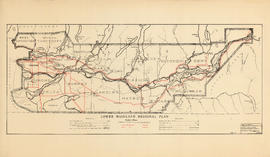
Lower Mainland Regional Plan : base map
Land use : Semlin Drive to Nanaimo Street and Burrard Inlet to Triumph Street
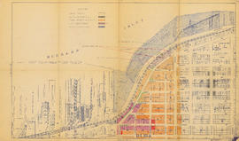
Properties from Victoria Drive to Nanaimo Street and Burrard Inlet to Triumph Street
Topographic map of Downtown Vancouver and the East End
Map of Marpole
Map and guide of Greater Vancouver
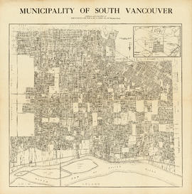
Municipality of South Vancouver
Plan of district lots 264, 265, 266 and 552, North Vancouver, British Columbia
Portions of New Westminster District and Vancouver Island
Southerly portion. Vancouver Island
Map of the south-western part of British Columbia
Vancouver, British Columbia
Vancouver
Plan of West Vancouver Municipality
Plan of Point Grey Municipality [ward boundaries]
Plan of government subdivision at Point Grey, B.C.
Plan of the City of Vancouver, B.C.
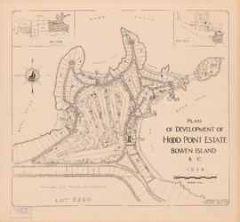
Plan of development of Hood Point Estate, Bowen Island, B.C., 1928
Municipality of South Vancouver
University Endowment Lands : plan of units no. 1 and 2
Lot numbers, boundaries, railway lines and street names in the municipality of Point Grey
Plan of town of Lonsdale : situate [sic] on harbour opposite City of Vancouver
British Columbia : Port Moody sheet : west of seventh, east and west of coast meridians
Powell Lake
Plan showing parcels 'A', 'B' & 'C' : Kitsilano Indian Reserve, No. 6 of the Squamish band, Vancouver, B.C.
Sectional map, city of Vancouver, B.C. : Renfrew Heights, subdivision in a part of the town of Hastings, suburban lands
Sectional map : City of Vancouver, B.C. : sheet no. S.V. 29
Plan of the municipality of South Vancouver
Plan of provincial government property being a portion of townsite of Vancouver and sub-division of lot 540, group 1, New Westminster District, B.C., to be sold by public auction at Vancouver, B.C.
Plan of part of sub-division of district lot 540, South Vancouver, provincial government property
Plan of provincial government property being a sub-division of a portion of expired timber lease situated in North Vancouver, New Westminster district, B.C., to be sold by public auction
Plan of sub-division of lot 2027, group 1, New Westminster District, B.C., to be sold by public auction at Vancouver, B.C.
Portions of New Westminster District and Vancouver Island
Area bounded by Kaslo St., 14th Ave., Renfrew St. and 18th Ave. : lands affected by proposed filling of Still Creek
Vancouver
Municipality of North Vancouver [Burrard Inlet]
[Vancouver, B.C. : district lots]
Plan of part of D.L. 540
Plan of part of subdivision of district lot 540. South Vancouver
Plan of Provincial Government property being a portion of Townsite of Vancouver
Canadian Pacific map of Vancouver [west half]
Plan of the City of Vancouver, British Columbia
Sectional map [Kaslo Street to Yale Street to Cotton Drive to East 1st Avenue]

![Plan of re-subdivision of lots 3 to 14, subn [subdivision] 2 of bk [block] 3. D.L. 391 & 392](/uploads/r/null/4/a/4a0ea6aa076433c7bcad0c847f7acb3bb1046f7abf2801c48b97d9ca58f49a73/9bd508e4-c85e-4090-b266-27571c5d4dbc-MAP754_142.jpg)


![Plan of Point Grey Municipality [ward boundaries]](/uploads/r/null/a/c/a/aca691b3d6e49d092070fc230a88f5ca7bd346fc8c5894892d7cdc5a79b535ee/9a14b192-1858-43aa-ab28-d0b03a2304eb-MAP360_142.jpg)


![Plan of town of Lonsdale : situate [sic] on harbour opposite City of Vancouver](/uploads/r/null/c/5/d/c5d4b56db1d7f9e1cf57dd5a974f6fcb23507e64543bad1bdd8f62139042389f/1cc57eaf-6c92-438e-a65d-335940738df7-MAP686_142.jpg)


![Municipality of North Vancouver [Burrard Inlet]](/uploads/r/null/6/d/6d0d9a4b75b38672c56aa89a5984fe2d0e6d66be85f6f375cbe8e2fd7ac94a98/577914e1-3de2-478b-a629-5f391731387a-MAP588_142.jpg)
![[Vancouver, B.C. : district lots]](/uploads/r/null/4/a/4a5c15633319c3754d3aa0cc525470bfebcf5a98ad8caeedf44b777194f300bd/2f055d65-47f7-4679-bb91-66b8f1843d2f-MAP531_142.jpg)


![Canadian Pacific map of Vancouver [west half]](/uploads/r/null/f/a/fa49266d21715d75ce93883012d471657dd058b90843927ec82b44d2bb42b007/f12ea9a5-4914-4db8-bda9-312aa2e2ccef-MAP10_142.jpg)

![Sectional map [Kaslo Street to Yale Street to Cotton Drive to East 1st Avenue]](/uploads/r/null/5/b/5b3ce173622ff68f920706abdf2b71af76caf9469cb2cbd3346b37f55694015e/4e7b285b-63cb-45b1-8e0c-6002788dbae6-MAP427_142.jpg)


