
Plan of Greater Vancouver. British Columbia
- COV-S371---: LEG1153.086
- Item
- 1911
Part of City of Vancouver fonds
Item is a commercially printed map which has been annotated to depict various Burrard Inlet crossings and underwater features.
37 results with digital objects Show results with digital objects
Plan of Greater Vancouver. British Columbia
Part of City of Vancouver fonds
Item is a commercially printed map which has been annotated to depict various Burrard Inlet crossings and underwater features.

Part of City of Vancouver fonds
Item is a map which depicts the waterworks infrastructure in Vancouver such as pipelines, tunnels, intakes, proposed reservoirs, etc.

Plan showing relative position of different water districts
Part of City of Vancouver fonds
Item is a map which depicts the boundaries between the various water districts between the Capilano River and the North Arm of Burrard Inlet.
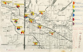
General overview of high-tech industry demographics
Part of City of Vancouver fonds
Item is a map annotated to show technology industry activities in Lower Mainland municipalities. Categories of activity are design/fabrication, system design/consulting, research/development, education, fabrication/manufacturing, and other. Item includes a list of the number of firms in each location.
![Vancouver's high-tech industry location map plus G.V.R.D. [Greater Vancouver Regional District] d...](/uploads/r/null/2/b/7/2b7c912f51dd7827d1a0ac60042357a631d2c8fdc3487bc37f286d2945c4ea4c/7a17e6a4-d593-45c5-9625-f03c471efb68-LEG1362_142.jpg)
Part of City of Vancouver fonds
Item is a map annotated to show locations of Vancouver technology firms. Categories of activity are system design/consulting, fabrication/manufacturing, design/fabrication, research/development, and other. Base map is a street map produced by the Engineering Department.
Guide map : Vancouver, New Westminster, Burnaby and North Shore municipalities
Item is a City Map and White Print Co. street map of Vancouver, Burnaby, New Westminster, North Vancouver and West Vancouver, annotated to show traffic density along major arteries. Various locations along the arteries are marked, but the significance of the markings is unclear. A small key map showing Vancouver in relation to the rest of the lower mainland has also been added to the base map.

Part of City of Vancouver Archives technical and cartographic drawing collection
Item is a map of the Lower Mainland from the City of Vancouver east to Port Coquitlam, including the North Shore municipalities, Vancouver, Burnaby, New Westminster, the western portion of Port Coquitlam, Richmond, and the northern portion of Surrey. The pictorial map is in the form of an oblique aerial view oriented to the E/NE.

Composite aerial mosaic of metropolitan Vancouver
Part of City of Vancouver Archives technical and cartographic drawing collection
Item is a map in the form of a composite aerial photograph showing Greater Vancouver, including West Vancouver, North Vancouver, Vancouver, Burnaby, New Westminster, Port Coquitlam, Coquitlam, Richmond, Delta and Surrey.
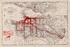
![Commercial map of Greater Vancouver and district [assessment districts]](/uploads/r/null/0/9/2/0928add1a06ab55bc236f8bebb87712b7e6ad4422db32cc3065efe7c9da96c04/b5b4129d-f9ba-49b9-a863-2ab6e954897e-MAP102_142.jpg)
Commercial map of Greater Vancouver and district [assessment districts]
Part of City of Vancouver Archives technical and cartographic drawing collection
Item is a printed map of greater Vancouver which has been used as a base map. The base map is the 1924 version of the Commercial Map of Greater Vancouver and District. On this copy has been drawn the boundaries of districts, numbered 1-12; inside the drawn boundaries are each district's area in acrea, population and assessed value of property. While the base map is of the pre-amalgamation municipalities, the assessment districts (?) cover the entire post-amalgamation extent of Vancouver.

Part of City of Vancouver Archives technical and cartographic drawing collection
Item is a map of Greater Vancouver annotated to show ward boundaries. Base map shows streets, some district lot numbers, and distances from City Hall. A smaller detail map shows Granville Island.
Composite aerial photographic map of the greater Vancouver area
Part of City of Vancouver Archives technical and cartographic drawing collection
Item is a map made up of a collage of aerial photogrpahs showing the greater Vancouver area bounded approximately by the North Shore Mountains in the north, the Gulf of Georgia in the west, the Burnaby-Coquitlam border in the east, and the Fraser River and parts of Surrey and Lulu Island (Richmond) in the south. Neither the photograph or who was responsible for the composite is identified.
Regional roads policy. Municipal truck routes
Part of City of Vancouver Archives technical and cartographic drawing collection
Regional road policy . Provincial highways
Part of City of Vancouver Archives technical and cartographic drawing collection
Regional roads policy. Fast bus network
Part of City of Vancouver Archives technical and cartographic drawing collection
B.C. Electric Railway lines completed and under construction
Part of City of Vancouver Archives technical and cartographic drawing collection
Map shows B.C. Electric Railway lines completed (in red), B.C. Electric Railway lines under construction (in yellow), lot numbers and major roads in the Greater Vancouver area from Burrard Inlet in the north to the north arm of the Fraser River in the south and from New Westminster in the east to Point Grey in the west.
Indexed guide map of Greater Vancouver and district [Proposed scenic drive]
Item is a published road map of Greater Vancouver which has been annotated to show the route of a proposed circular scenic drive route through Vancouver, Burnaby, New Westminster, Coquitlam and Port Moody, as well as a proposed arterial route connecting the Pitt River Bridge to the Vancouver road network at Boundary Road.
The proposed scenic drive follows a route along Hastings Street, Stanley Park Drive, and along the entire route of Marine Drive around the University Endowment lands and east through southern Burnaby, then north from New Westminster through Coquitlam near the Alouette River.
The two pages of textual records transferred with the map itemize the specifications for paving for each section of the road.
Vancouver Park Board
Part of City of Vancouver Archives technical and cartographic drawing collection
Map shows major roads, parks, landmarks and tourist attractions in Vancouver and parts of West Vancouver, North Vancouver and Burnaby. The map shows the area from Grouse Mountain in the north to Vancouver International Airport in the south and from Burnaby Lake in the east to Lighthouse Park and the University Endowment Lands in the west
Part of City of Vancouver Archives technical and cartographic drawing collection
Map is an aerial photograph of the Greater Vancouver area.
Vancouver, British Columbia : [urban analysis maps]
Part of City of Vancouver Archives technical and cartographic drawing collection
Maps show land use, land slope and elevation, density of buildings, structural material of buildings, height of buildings, water supply systems, sewage systems, electric power systems, gas trunk systems, population distribution, daytime population distribution, dwelling units, schools, hospitals and doctors, land transportation, port facilities, food manufacturing, textile manufacturing, wood product manufacturing, metal product manufacturing, transportation equipment manufacturing, non-metallic mineral and chemical products manufacturing, retail and wholesale food enterprises, retail and wholesale building materials enterprises, retail and wholesale drugs, general merchandise, apparel and accessories enterprises, retail and wholesale clothing and shoes enterprises, retail and wholesale furnishing enterprises and hotels and eating places in the Greater Vancouver area (including West Vancouver, North Vancouver, Vancouver, Burnaby, New Westminster, the northern portion of Richmond and the western portion of Coquitlam). Much of the data for these maps was derived from the 1961 census of Canada.
Vancouver : spectacular by nature : official courtesy map
Part of City of Vancouver Archives technical and cartographic drawing collection
Primary map on recto shows major roads, hotels, travel apartments, parks, golf courses, gardens, recreational facilities, historical and cultural attractions, shopping centres and other places of interest in the downtown, Stanley Park, Kitsilano and Fairview areas. The map on verso shows similar details for Greater Vancouver (including West Vancouver, North Vancouver, Vancouver, Burnaby, Port Moody, Port Coquitlam, Coquitlam, Pitt Meadows, Maple Ridge, New Westminster, Langley, Surrey, Delta, Richmond and White Rock.
Railroads of the Lower Mainland of British Columbia
Part of City of Vancouver Archives technical and cartographic drawing collection
Primary map shows railroads, railroad names, subdivisions, spurs or yards, timetable station names, station buildings, absolute signals, signal identities, hot boxes and/or dragging equipment detectors, mileboards, bridges and interchanges in the Greater Vancouver area from West Vancouver in the north to the United States border in the south and from Haney in the east to Horseshoe Bay in the west. Ancillary maps show the B.C. Rail Squamish subdivision, the Vancouver B.N., C.N. and C.P. railroad yards, New Westminster C.N., C.P. and S.R.Y. railroad details, Burlington Northern Brunette details, the Canadian National Thornton Yard and Coquitlam C.P. details.
Railroads of the Lower Mainland of British Columbia, 1882-1992
Part of City of Vancouver Archives technical and cartographic drawing collection
Primary map shows existing track, abandoned track, station buildings and bridges in the Greater Vancouver area from West Vancouver in the north to the United States border in the south and from Haney in the east to Horseshoe Bay in the west. Ancillary maps show details of Vancouver B.C.E., C.No.P., C.P. and G.N. railroad yards and New Westminster B.C.E., C.No.P., C.P. details. The item also includes a chronology of railroad subsidiaries, takeovers and mergers.
Part of City of Vancouver Archives technical and cartographic drawing collection
Map shows major highways and zoning in the Greater Vancouver area according to the following: residential, commerical, industrial, civic and institutional, parks and recreational and agricultural.

Part of City of Vancouver Archives technical and cartographic drawing collection
Item is a map showing topography, roads, trails, railways, bridges, boundaries, reserves, power lines, telephone lines, triangulation stations, camera stations, bench marks, houses, barns, mills, factories, schools, churches, post offices, telephone exchanges, mines and geographic features in the area of South Burnaby and New Westminster, extending south through Surrey and White Rock to the United States border. A small index map shows the area covered by the primary map in relation to other maps in the series.

Part of City of Vancouver Archives technical and cartographic drawing collection
Item is a map showing topography, roads, trails, railways, bridges, boundaries, reserves, power lines, telephone lines, triangulation stations, camera stations, bench marks, houses, barns, mills, factories, schools, churches, post offices, telephone exchanges, mines and geographic features in the Pitt Meadows area and extending south through Cloverdale and Langley to the United States border. A small index map shows the area covered by the primary map in relation to other maps in the series.
Part of City of Vancouver Archives technical and cartographic drawing collection
Item is a map showing topography, roads, trails, railways, bridges, boundaries, reserves, power lines, telephone lines, triangulation stations, camera stations, bench marks, houses, barns, mills, factories, schools, churches, post offices, telephone exchanges, mines and geographic features in the area of southern Vancouver and Richmond, extending south to the United States border. A small index map shows the area covered by the primary map in relation to other maps in the series.

Part of City of Vancouver Archives technical and cartographic drawing collection
Item is a map showing topography, roads, trails, railways, bridges, boundaries, reserves, power lines, telephone lines, triangulation stations, camera stations, bench marks, houses, barns, mills, factories, schools, churches, post offices, telephone exchanges, mines and geographic features in the area of southern Gambier Island, Bowen Island, Whytecliff, and Caulfeild. A small index map shows the area covered by the primary map in relation to other maps in the series.

Part of City of Vancouver Archives technical and cartographic drawing collection
Item is a map showing topography, roads, trails, railways, bridges, boundaries, reserves, power lines, telephone lines, triangulation stations, camera stations, bench marks, houses, barns, mills, factories, schools, churches, post offices, telephone exchanges, mines and geographic features in the area from Mount Hanover in the north through West Vancouver and North Vancouver, extending south to the northern part of Vancouver. A small index map shows the area covered by the primary map in relation to other maps in the series.
Part of City of Vancouver Archives technical and cartographic drawing collection
Item is a map showing topography, roads, trails, railways, bridges, boundaries, reserves, power lines, telephone lines, triangulation stations, camera stations, bench marks, houses, barns, mills, factories, schools, churches, post offices, telephone exchanges, mines and geographic features in the area of Indian Arm and Coquitlam Lake, extending south to Port Moody, Port Coquitlam, and the northeast part of Burnaby. A small index map shows the area covered by the primary map in relation to other maps in the series.

Part of City of Vancouver Archives technical and cartographic drawing collection
Item is a map showing topography, roads, trails, railways, bridges, boundaries, reserves, power lines, telephone lines, triangulation stations, camera stations, bench marks, houses, barns, mills, factories, schools, churches, post offices, telephone exchanges, mines and geographic features in the Pitt Lake area, including Coquitlam Mountain, Mount Blanshard, and Siwash Island. A small index map shows the area covered by the primary map in relation to other maps in the series.
Indexed guide map of the City of Vancouver and suburbs
Part of City of Vancouver Archives technical and cartographic drawing collection
Item is a sheet with a map on the recto and text on the verso. The map shows District Lots in Vancouver, South Vancouver, Point Grey, Burnaby, Richmond, New Westminster, West Vancouver, and North Vancouver.
B.C. Electric guide to Greater Vancouver
Part of City of Vancouver Archives technical and cartographic drawing collection
Item is a pamphlet with a system map on one side and details maps, street indexes, places of general interest, lists of schools and a list of B.C. Electric routes on the other.
The service route to - from - through industrial southwestern British Columbia
Part of City of Vancouver Archives technical and cartographic drawing collection
Item is a pamphlet which shows lines operated by B.C. Hydro and Power Authority including the V & LI Branch of the Canadian Pacific Railway (the BCE Route) in Greater Vancouver. An index map of British Columbia was designed to display on the back page of the pamphlet when folded.
Visit the Scenery Shop, souvenir headquarters
Part of City of Vancouver Archives technical and cartographic drawing collection
Item is a promotional brochure for The Scenery Shop, a retailer of souvenirs located at 656 Granville Street. One side of the brochure when unfolded displays a map designed by the shop's proprietor, William L. Webber, showing points of interest and an inset map showing the location of the shop. The other side of the unfolded sheet shows photographs and lists of products available in the shop.

Map of New Westminster District, B.C
Part of City of Vancouver Archives technical and cartographic drawing collection
Item is a map showing District Lots in Vancouver, and township/range designations in other areas. The map also shows False Creek Trail, North Arm Road, False Creek Road, Granville Road from Granville to Hastings, New Westminster and Burrard Inlet Road, North Road, Semiahmoo Road, New Westminster and Yale Wagon Road, and others. Annotated by W. E. Graveley, 1885, to show additional features including Kingsway, Haney, Albion Camp, etc.
B.C. Electric guide to Greater Vancouver
Part of City of Vancouver Archives technical and cartographic drawing collection
Item is a transit guide in the form of a brochure. On the exterior side of the unfolded sheet is information about BC Electric routes, points of interest in the city, and smaller inset maps. The principal map is on the verso.
Wrigley's 1930 map of Vancouver and Lower Mainland
Part of City of Vancouver Archives technical and cartographic drawing collection
Item is a map of Greater Vancouver with a street index on verso. Map shows streets, paved streets, trails, street car lines, bus lines, railways, auto camps, hospitals, schools and block numbers. Concentric circles spaced one mile apart emanate from a point in downtown Vancouver.
Part of City of Vancouver Archives technical and cartographic drawing collection
Item is a tourism brochure with a map on one side and tourism information on the reverse.
B.C. Electric guide to Greater Vancouver
Part of City of Vancouver Archives technical and cartographic drawing collection
Item is a transit guide in the form of a brochure. On the exterior side of the unfolded sheet is information about BC Electric routes, points of interest in the city, and smaller inset maps. The principal map is on the verso.
Guide map : Vancouver - New Westminster, Burnaby and North Shore
Part of City of Vancouver Archives technical and cartographic drawing collection
Item is a map of Greater Vancouver with a street index on verso. Map shows city streets, schools, firehalls, parks and golf courses, railways, street railways and interurban lines, hospitals and bus routes.
Map of Greater Vancouver and Lower Mainland area
Part of City of Vancouver Archives technical and cartographic drawing collection
Item is a brochure with various street maps of Greater Vancouver, folded and enclosed in an attached folder with promotional material on the Vancouver Real Estate Board and information on sites of interest in the area.
Part of City of Vancouver Archives technical and cartographic drawing collection
Item is a map and tourist guide to Vancouver showing major roadways and tourist attractions in the Greater Vancouver area on one side, and Stanley Park, downtown Vancouver, and textual tourist information on the other.
B.C. Electric guide to Greater Vancouver
Part of City of Vancouver Archives technical and cartographic drawing collection
Item is a transit guide in the form of a brochure. On the exterior side of the unfolded sheet is information about BC Electric routes, points of interest in the city, and smaller inset maps. The principal map is on the verso.
Map of Greater Vancouver and Lower Mainland area
Part of City of Vancouver Archives technical and cartographic drawing collection
Item is a brochure with various street maps of Greater Vancouver, folded and enclosed in an attached folder with promotional material on the Vancouver Real Estate Board and information on sites of interest in the area.
Part of City of Vancouver Archives technical and cartographic drawing collection
Item is a brochure for Spencer's Department Store, with a map of the city on the verso.
B.C. Electric guide to Greater Vancouver
Part of City of Vancouver Archives technical and cartographic drawing collection
Item is a transit guide in the form of a brochure. On the exterior side of the unfolded sheet is information about BC Electric routes, points of interest in the city, and smaller inset maps. The principal map is on the verso.

Vancouver, New Westminster, Delta and Surrey : postal area
Part of City of Vancouver Archives technical and cartographic drawing collection
Item is a map which shows the boundaries of postal areas and their corresponding numbers and names.
![[Aerial map of Greater Vancouver]](/uploads/r/null/5/6/0/560c4a977bf4bd23ded38e3e8d0c471a86a303d135869c5e459d1977eeed33a6/f660f804-da91-422b-9622-82ae60a89bbe-MAP358_142.jpg)
[Aerial map of Greater Vancouver]
Part of City of Vancouver Archives technical and cartographic drawing collection
Map is a poster of an aerial photograph showing Vancouver, North Vancouver, West Vancouver, Richmond, Burnaby, Delta, Coquitlam, Port Coquitlam, Port Moody, and Surrey. It also shows location of Sea Island Industrial Park and Lake-City Industrial Park which Webb & Knapp sponsor. "Lake-City Industrial Park and Sea Island Industrial Park, comprising approximately 900 acres of industrial estate property".

Commercial map of Greater Vancouver and district
Part of City of Vancouver Archives technical and cartographic drawing collection
Item is a map sheet containing two maps. The principal map depicts greater Vancouver, including portions of North and West Vancouver, Richmond and Surrey. The information depicted on the map includes streets, postal blocks, streetcar and railway lines, parks and golf courses, and schools. The map includes 1/2 mile distance circles centred on old City Hall at Main and Hastings.
The sheet includes an inset map of Granville Island. Depth of water given along shorelines of Burrard Inlet, English Bay, and along the West Vancouver coast from First Narrows to Howe Sound. The sheet includes an index of streets.