Design concept for proposed National Avenue pedestrian bridge connection (Main St.)
- COV-S507---: LEG2285.0069
- Item
- May 4, 1984
Part of City of Vancouver fonds
Vancouver (B.C.). Planning Department
10 results with digital objects Show results with digital objects
Design concept for proposed National Avenue pedestrian bridge connection (Main St.)
Part of City of Vancouver fonds
Vancouver (B.C.). Planning Department
Part of City of Vancouver fonds
Item consists of map depicting the volume of buses service on various downtown routes. Data is depicted as scaled lines depicting route streets, with the scale of 1 mm of line width = 10 buses/hour.
Vancouver (B.C.). Planning Department
Part of City of Vancouver fonds
Item consists of a map depicting the locations of bus stops in the downtown area, with scaled lines that most likely depict volume of bus services during rush hour.
Vancouver (B.C.). Planning Department
Existing service stations, retail shopping centres and commercial zoning
Part of City of Vancouver Archives technical and cartographic drawing collection
Item is a map showing the locations of retail shopping centres in Vancouver according to local, district and regional function. Map also shows locations of service stations and commercially zoned areas.
Vancouver (B.C.). Planning Department
City of Vancouver urban renewal : scheme 3
Part of City of Vancouver fonds
Vancouver (B.C.). Planning Department
Aerial survey [photograph] #17
Part of Kitsilano Yacht Club fonds
Item is a map in the form of an aerial survey photograph which shows the west side of Vancouver bounded in the north and south by 14th Ave. and S.W. Marine Drive, and in the east and west by Blenheim St. and Sasamat St.
Vancouver (B.C.). Planning Department
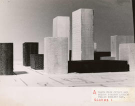
Taken from Chilco and Nelson streets looking towards English Bay
Part of City of Vancouver fonds
Item consists of a photograph depicting a model created by Planning Department staff to study view obstructions which result from various building configurations, based on different options to be included in zoning regulations for the West End.
Vancouver (B.C.). Planning Department

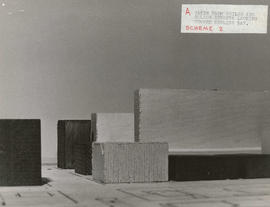
Taken from Comox and Nicola streets looking towards English Bay
Part of City of Vancouver fonds
Item consists of a photograph depicting a model created by Planning Department staff to study view obstructions which result from various building configurations, based on different options to be included in zoning regulations for the West End.
Vancouver (B.C.). Planning Department

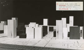
Taken from Pendrell and Broughton streets looking towards English Bay
Part of City of Vancouver fonds
Item consists of a photograph depicting a model created by Planning Department staff to study view obstructions which result from various building configurations, based on different options to be included in zoning regulations for the West End.
Vancouver (B.C.). Planning Department
Taken from Chilco and Nelson streets looking towards English Bay
Part of City of Vancouver fonds
Item consists of a photograph depicting a model created by Planning Department staff to study view obstructions which result from various building configurations, based on different options to be included in zoning regulations for the West End.
Vancouver (B.C.). Planning Department

Taken from Comox and Bidwell streets looking towards English Bay
Part of City of Vancouver fonds
Item consists of a photograph depicting a model created by Planning Department staff to study view obstructions which result from various building configurations, based on different options to be included in zoning regulations for the West End.
Vancouver (B.C.). Planning Department
Taken from Comox and Nicola streets looking towards English Bay
Part of City of Vancouver fonds
Item consists of a photograph depicting a model created by Planning Department staff to study view obstructions which result from various building configurations, based on different options to be included in zoning regulations for the West End.
Vancouver (B.C.). Planning Department

Taken from Pendrell and Broughton streets looking towards English Bay
Part of City of Vancouver fonds
Item consists of a photograph depicting a model created by Planning Department staff to study view obstructions which result from various building configurations, based on different options to be included in zoning regulations for the West End.
Vancouver (B.C.). Planning Department

Part of City of Vancouver Archives technical and cartographic drawing collection
Item is a copy of a Planning Department map of downtown Vancouver. This copy has a mylar overlay which masks the area north of Georgia Street between Bidwell and Chilco Streets.
Vancouver (B.C.). Planning Department
City of Vancouver : generalized future land use in relation to feasibility network
Part of City of Vancouver fonds
Item is a copy of an Engineering Department map which has been annotated to show pre-1916 residential construction, existing major streets, public and semi-public buildings, single and two-family dwellings, multiple family dwellings, district commercial, industrial, open spaces, proposed additional major streets - 1976, proposed deletion of existing major streets - 1976, proposed freeways and secondary schools in the city of Vancouver.
Vancouver (B.C.). Planning Department

Rezoning application map (Point Grey Road)
Part of City of Vancouver Archives technical and cartographic drawing collection
Item is a map that would have been created to accompany an application for re-zoning for Block 235 D.L. 538 and water lots 5834, 5601 and 5600. It appears that this application failed, as no amendment to By-law 3575 for these properties has been found.
Vancouver (B.C.). Planning Department