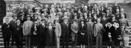
B.C. Automobile Club, Members and Delegates Picnic
- AM427-S4-: CVA 289-051
- Item
- 1925
Part of William Orson Banfield fonds
B.C. Automobile Club, Members and Delegates Picnic
Part of William Orson Banfield fonds

Boy driving threshing machine on Fraser Valley farm
Part of Vancouver Express fonds
![[Dirt track auto race]](/uploads/r/null/e/0/e0452f50a8b1238d0675ba1a88c300b88983b065e8ff4ec86e8b81f006d75edd/384c1671-a0d9-4fe0-960e-cf9decfd30da-A16853_142.jpg)
Part of Stuart Thomson fonds
![[Dirt track auto race]](/uploads/r/null/3/0/30e8f9a86cfad3ab4066e2613b2e493c83681e8ae9ea9ddb802eb6050a725aa1/37f2ab19-720d-4496-9699-dc53bc4f72a0-A16854_142.jpg)
Part of Stuart Thomson fonds
Part of Elizabeth Abbott fonds

Part of Elizabeth Abbott fonds
Part of Elizabeth Abbott fonds
Part of Elizabeth Abbott fonds
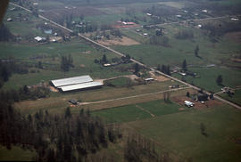
Geographical : Aerial Fraser Valley

Image is of an aerial view of farmland along the Fraser River.

Man in rowboat on floodwaters at washed out railroad tracks
Part of Elizabeth Abbott fonds
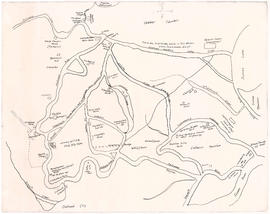
Map of early Chilliwack district
Part of City of Vancouver Archives technical and cartographic drawing collection
Item is a map of the area around Chilliwack and Vedder Mountain showing early family settlements, roads, rivers, churches, stores and other landmarks.
Sepass, William (Billy)

Item is a map of the Fraser Valley from Vancouver to Chilliwack showing roads, railway lines, schools, churches, and post offices.

Map of Fraser Valley, British Columbia
Item is a map showing trunk roads, main and local roads, and railway lines.

Map of New Westminster District, B.C
Part of City of Vancouver Archives technical and cartographic drawing collection
Item is a map showing District Lots in Vancouver, and township/range designations in other areas. The map also shows False Creek Trail, North Arm Road, False Creek Road, Granville Road from Granville to Hastings, New Westminster and Burrard Inlet Road, North Road, Semiahmoo Road, New Westminster and Yale Wagon Road, and others. Annotated by W. E. Graveley, 1885, to show additional features including Kingsway, Haney, Albion Camp, etc.

Men in boat on floodwaters at washed out railroad tracks
Part of Elizabeth Abbott fonds

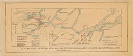
Plan showing locations of oil and gas seepages and oil wells in Fraser Valley, British Columbia
Part of City of Vancouver Archives technical and cartographic drawing collection
Item is a map which shows rivers and streams, oil and gas seepages, oil wells drilled, towns and villages and railway lines from Pitt Lake in the north to the United States border in the south and from Chilliwack in the east to the Strait of Georgia in the west.
Haggen, E.A.

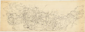
Profile Mile 27 to Mile 58 Port Mann Subdivision
Part of City of Vancouver fonds
Item is a profile of the Canadian Northern Railway right of way through the Fraser Valley.

Propagation : greenhouses, Fraser Valley

Railroad tracks and parts tied down during flood
Part of Elizabeth Abbott fonds
Street map of the Fraser Valley
Item is a street map of the Lower Mainland and Fraser Valley from Vancouver to Chilliwack.

Three men afloat on raft on floodwaters
Part of Elizabeth Abbott fonds

Vancouver : as seen from space : vue de l'espace
Part of City of Vancouver Archives technical and cartographic drawing collection
Map shows Vancouver, the Fraser Valley and a portion of the Gulf Islands as seen from space.

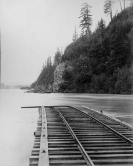
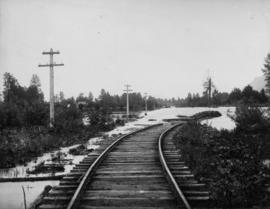
View of railroad tracks during flood
Part of Elizabeth Abbott fonds

Part of Elizabeth Abbott fonds

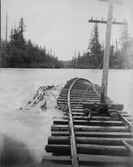
Washed out railroad tracks during flood
Part of Elizabeth Abbott fonds

Washed out railroad tracks during flood
Part of Elizabeth Abbott fonds

Washed out railroad tracks during flood
Part of Elizabeth Abbott fonds