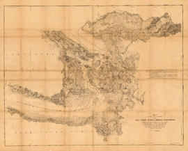
Showing 19 results

Archival description
City of Vancouver Archives technical and cartographic drawing collection New Westminster (B.C.) Item
Print preview View:

9 results with digital objects Show results with digital objects

Map showing the line of boundary between the United States and British possessions

Item is a map showing four proposed boundaries between the United States and British possessions in the Salish Sea region. The explanations of the lines read in part: "[1] Boundary line contemplated by the Treaty as shown by contemporaneous evidence; [2] Boundary line as claimed by the British Commissioner; [3] Boundary line proposed by the British Commissioner as a compromise ( . . . ); [4] Boundary line in accordance with the strict letter of the Treaty ( . . . ). Item also shows soundings, and the "track of steamers plying between Victoria and Fraser river since discovery of gold."

Sectional map and street directory of Vancouver : Dial map of the city of Vancouver including adjacent municipalities

Item is a street map showing Vancouver, Burnaby, New Westminster, West Vancouver, and North Vancouver on one side and the Lower Mainland from Vancouver to Chilliwack on the other. Item includes lists of businesses, schools, public buildings, hospitals, bathing beaches, fire halls, and golf and country clubs, as well as text advertising the products and services of the Dominion Map and Blueprint Company.

Town-site of Hastings

Map shows Hastings Town-site, Granville Town-site, Burnaby, and the City of New Westminster. Map also shows the Road from Granville and the False Creek Trail, as well as the names of places and soil types found along these roads. Other places and structures noted include Burrard Inlet, Coal Harbour (Coal Harbor on map), False Creek, False Creek Bridge, Burnaby Lake, Fraser River, New Westminster and Burrard Inlet Road, Douglas Road, Edinburgh Street, Columbia Street, Richards Street, and the New Westminster Cemetery. Two notes on map read "Plan to accompany Report of 1st May 1883, Joseph Hunter" and "Memo: Mr. Ross will place [?] this map to the [Engs.] Office Victoria [?]." 14T3 Roads & Trails is printed on the side of the map.