Geographical : Aerial Fraser Valley
- AM1502-S1-2-: CVA 1502-1427
- Item
- [Apr. 5, 1990]
29 results with digital objects Show results with digital objects
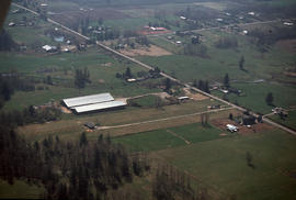
Geographical : Aerial Fraser Valley

Image is of an aerial view of farmland along the Fraser River.

Propagation : greenhouses, Fraser Valley
Part of City of Vancouver Archives technical and cartographic drawing collection
Item is a pamphlet with a map on one side and text on the other. The map shows the location of churches, school, canaries, sawmills, backyards, tanneries, woolen mills, hatcheries, roads, and railways on a map which depicts the area of Greater Vancouver from the Gulf of Georgia east to Harrison Lake and south to the United States border. The verso contains information concerning the city and district of New Westminster, with individual panels on the municipalities of Delta, Chilliwhack [sic], Surrey, Langley, and Delta, and the City of New Westminster, the town of Harrison Hot Springs and the province.
Map of the Fraser Valley showing railway lines and district lots
Part of City of Vancouver Archives technical and cartographic drawing collection
Item contains a map of the Fraser Valley showing railway lines and district lots on one side and text advertising the British Columbia Electric Railway Company's interurban lines on the other.
Map of railway freight lines operated by British Columbia Hydro and Power Authority
Part of City of Vancouver Archives technical and cartographic drawing collection
Item is a map showing the B.C. Electric railway (including the Vancouver and Lulu Island branch), other railways, interchange points and municipal city boundaries. Map is designed to be folded in two; cover on verso.
Greater Vancouver and Fraser Valley
Part of City of Vancouver Archives technical and cartographic drawing collection
Item is a pamphlet containing a map of Greater Vancouver and the Fraser Valley on one side and text promoting British Columbia and the services of Western Development and Power Limited on the other. Map shows the B.C. Electric railway line within the Greater Vancouver and Fraser Valley area, other railway lines, main roads, municipal boundaries, industrial sites, airports and ports. An inset map shows the total area served by B.C. Electric within British Columbia and the location of Greater Vancouver and the Fraser Valley within that area.
200 miracle miles through the Lower Fraser Valley
Part of City of Vancouver Archives technical and cartographic drawing collection
Item is a tourist brochure promoting tourism in the lower Fraser Valley. The map on one side of the unfolded sheet shows locations of tourist attractions in the Lower Fraser Valley and includes an approximate mileage table. The other side of the sheet has information and photographs of some of the tourist attractions listed on map.
Item is a street map showing Vancouver, West Vancouver, North Vancouver, and Burnaby on one side and the Fraser Valley, New Westminster, and Greater Vancouver transit lines on the other. Item also includes text advertising the products and services of the Dominion Map and Blueprint Company.
Item is a street map showing Vancouver, West Vancouver, North Vancouver, and Burnaby on one side and the Lower Mainland from Vancouver to Chilliwack, Richmond, and New Westminster on the other. Item also includes text advertising the products and services of Dominion Map and Blueprint Ltd.
Item is a street map showing Vancouver, West Vancouver, North Vancouver and Burnaby on one side and the Fraser Valley, New Westminster, Richmond, Delta, and Surrey on the other. Item also includes text advertising the products and services of the Dominion Map and Blueprint Company.
Item is a street map showing Vancouver, West Vancouver, North Vancouver and Burnaby on one side and the Lower Mainland from Vancouver to Chilliwack on the other. Item also includes information about bus services in Greater Vancouver and text advertising the products and services of the Dominion Map and Blueprint Company.
Item is a street map showing Vancouver, West Vancouver, North Vancouver and Burnaby on one side and the Lower Mainland from Vancouver to Chilliwack on the other. Item also includes information about bus services in Greater Vancouver and text advertising the products and services of the Dominion Map and Blueprint Company.
Item is a street map showing Vancouver, West Vancouver, North Vancouver and Burnaby on one side and the Fraser Valley and New Westminster on the other.
Item is a street map showing Vancouver, Burnaby, New Westminster, West Vancouver, and North Vancouver on one side and the Lower Mainland from Vancouver to Chilliwack on the other. Item includes lists of businesses, schools, public buildings, hospitals, bathing beaches, fire halls, and golf and country clubs, as well as text advertising the products and services of the Dominion Map and Blueprint Company.
Part of City of Vancouver Archives technical and cartographic drawing collection
Item is a street map showing Vancouver, Burnaby, New Westminster, West Vancouver, and North Vancouver on one side and the Lower Mainland from Vancouver to Chilliwack on the other. Item includes lists of businesses, schools, public buildings, hospitals, bathing beaches, fire halls, and golf and country clubs, as well as text advertising the products and services of the Dominion Map and Blueprint Company.
Street map of Greater Vancouver
Part of City of Vancouver Archives technical and cartographic drawing collection
Item is a published road map, created for and distributed by Home Oil Distributors, with a map of Greater Vancouver on one side and maps of the Fraser Valley, Surrey and Richmond (iwth street indexes) on the other. The maps show roads, block numbers, boundaries, highway markers and Home Oil gas stations.
Part of City of Vancouver Archives technical and cartographic drawing collection
Item is a road maps in the form of a folded brochure. It includes information on the British Columbia Automobile Association, road maps for various municipalities and diagrams of highway interchanges in the Lower Mainland and Fraser Valley.

Boy driving threshing machine on Fraser Valley farm
Part of Vancouver Express fonds
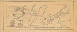
Plan showing locations of oil and gas seepages and oil wells in Fraser Valley, British Columbia
Part of City of Vancouver Archives technical and cartographic drawing collection
Item is a map which shows rivers and streams, oil and gas seepages, oil wells drilled, towns and villages and railway lines from Pitt Lake in the north to the United States border in the south and from Chilliwack in the east to the Strait of Georgia in the west.
Haggen, E.A.
Part of Elizabeth Abbott fonds
Part of Elizabeth Abbott fonds

Part of Elizabeth Abbott fonds
Part of Elizabeth Abbott fonds

Three men afloat on raft on floodwaters
Part of Elizabeth Abbott fonds

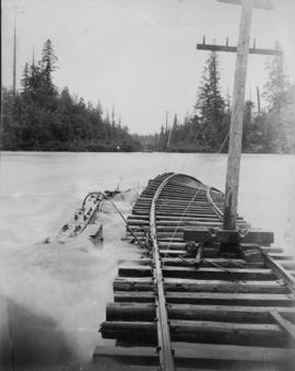
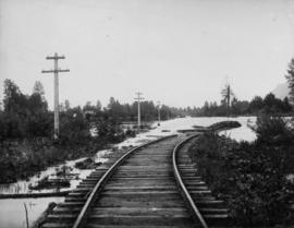
Washed out railroad tracks during flood
Part of Elizabeth Abbott fonds

Men in boat on floodwaters at washed out railroad tracks
Part of Elizabeth Abbott fonds

Man in rowboat on floodwaters at washed out railroad tracks
Part of Elizabeth Abbott fonds

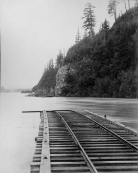
View of railroad tracks during flood
Part of Elizabeth Abbott fonds

Part of Elizabeth Abbott fonds

Railroad tracks and parts tied down during flood
Part of Elizabeth Abbott fonds

Washed out railroad tracks during flood
Part of Elizabeth Abbott fonds

Washed out railroad tracks during flood
Part of Elizabeth Abbott fonds
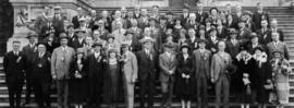
B.C. Automobile Club, Members and Delegates Picnic
Part of William Orson Banfield fonds
Vancouver, B.C. and vicinity road map
Part of City of Vancouver Archives technical and cartographic drawing collection
Item is a road map of Greater Vancouver and other surrounding areas, created for Standard Oil and distributed by Chevron gasoline stations.
![[Dirt track auto race]](/uploads/r/null/e/0/e0452f50a8b1238d0675ba1a88c300b88983b065e8ff4ec86e8b81f006d75edd/384c1671-a0d9-4fe0-960e-cf9decfd30da-A16853_142.jpg)
Part of Stuart Thomson fonds
![[Dirt track auto race]](/uploads/r/null/3/0/30e8f9a86cfad3ab4066e2613b2e493c83681e8ae9ea9ddb802eb6050a725aa1/37f2ab19-720d-4496-9699-dc53bc4f72a0-A16854_142.jpg)
Part of Stuart Thomson fonds
Street map of the Fraser Valley
Item is a street map of the Lower Mainland and Fraser Valley from Vancouver to Chilliwack.

Item is a map of the Fraser Valley from Vancouver to Chilliwack showing roads, railway lines, schools, churches, and post offices.

Profile Mile 27 to Mile 58 Port Mann Subdivision
Part of City of Vancouver fonds
Item is a profile of the Canadian Northern Railway right of way through the Fraser Valley.

Vancouver : as seen from space : vue de l'espace
Part of City of Vancouver Archives technical and cartographic drawing collection
Map shows Vancouver, the Fraser Valley and a portion of the Gulf Islands as seen from space.
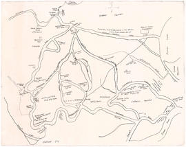
Map of early Chilliwack district
Part of City of Vancouver Archives technical and cartographic drawing collection
Item is a map of the area around Chilliwack and Vedder Mountain showing early family settlements, roads, rivers, churches, stores and other landmarks.
Sepass, William (Billy)
Part of City of Vancouver fonds

Map of Fraser Valley, British Columbia
Item is a map showing trunk roads, main and local roads, and railway lines.
Road map of the Lower Fraser Valley, western portion
Item shows streets, railways, and sewage dumps, including inset maps of cities and towns.
Road map of the Lower Fraser Valley, eastern portion
Item shows streets, railways, and sewage dumps, including inset maps of cities and towns.
Fraser Valley, Vancouver to Hope, Centennial Trail
Item consists of a road map of the eastern and western portions of the Lower Fraser Valley, including area details and street indexes.
Sectional map and street directory of the Fraser Valley British Columbia
Item is a copy of the Fraser Valley sectional map used as a worksheet.
Road map of the Lower Fraser Valley, eastern portion [right half]
Item is a copy of the road map for the eastern portion of the Lower Fraser Valley used as a worksheet.