- COV-S507---: LEG2281.0068
- Item
- Nov. 2, 1984
Part of City of Vancouver fonds
Vancouver (B.C.). Engineering Services
96 results with digital objects Show results with digital objects
Part of City of Vancouver fonds
Vancouver (B.C.). Engineering Services

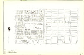
Plan of block occupied by University of British Columbia, Vancouver B.C.
Part of Major Matthews collection
Item is a site plan of the old University of British Columbia site bounded by Laurel Street, Tenth Avenue, Willow Street and 12th Avenue.
Vancouver (B.C.). Engineering Services

Redevelopment plan for Jericho Department of National Defence lands
Part of City of Vancouver Archives technical and cartographic drawing collection
Item is a map showing proposed redevelopment of portions of former Department of National Defence lands in the Jericho area. The map shows existing city parks, D.N.D. lands to be taken over for parks and recreation, city owned land, single family land, town houses, garden apartments and town houses and proposed new roads. The map appears to have been removed from a report.
Vancouver (B.C.). Engineering Services

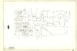
Sheet 61 : Cypress Street to Oak Street and Forty-first Avenue to Thirty-third Avenue
Part of City of Vancouver Archives technical and cartographic drawing collection
Item is a section showing the area from Cypress Street to Oak Street and Forty-first Avenue to Thirty-third Avenue. Includes streets, blocks, lots and legal descriptions.
Vancouver (B.C.). Engineering Services

Sheet 62 : Cypress Street to Oak Street and Forty-ninth Avenue to Forty-first Avenue
Part of City of Vancouver Archives technical and cartographic drawing collection
Item is a section showing the area from Cypress Street to Oak Street and Forty-ninth Avenue to Forty-first Avenue. Includes streets, blocks, lots and legal descriptions, and the locations of parks and schools.
Vancouver (B.C.). Engineering Services

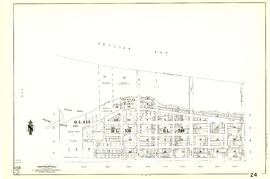
Index to 400 ft. scale section maps, City of Vancouver, British Columbia
Part of City of Vancouver Archives technical and cartographic drawing collection
Item is an index map for the sections which comprise the sectional map.
Vancouver (B.C.). Engineering Services

Sheet 10 : Clark Drive to Nanaimo Street and Frances Street to Burrard Inlet
Part of City of Vancouver Archives technical and cartographic drawing collection
Item is a section showing the area from Clark Drive to Nanaimo Street and Frances Street to Burrard Inlet. Includes streets, blocks, lots and legal descriptions, and the locations of parks and a juvenile detention home.
Vancouver (B.C.). Engineering Services

Sheet 12 : Nanaimo Street to Cassiar Street and Pender Street to McGill Street
Part of City of Vancouver Archives technical and cartographic drawing collection
Item is a section showing the area from Nanaimo Street to Cassiar Street and Pender Street to McGill Street. Includes streets, blocks, lots and legal descriptions, and the locations of bridges, reservoirs and railways.
Vancouver (B.C.). Engineering Services

Sheet 14 : Cassiar Street to Boundary Road and Pender Street to Eton Street
Part of City of Vancouver Archives technical and cartographic drawing collection
Item is a section showing the area from Cassiar Street to Boundary Road and Pender Street to Kitchener Street. Includes streets, blocks, lots and legal descriptions, and the locations of parks and retirement homes. Also shown are streets and blocks in the area from Boundary Road to Carleton Avenue in Burnaby.
Vancouver (B.C.). Engineering Services

Sheet 20 : Main Street to Clark Drive and Great Northern Way to Prior Street
Part of City of Vancouver Archives technical and cartographic drawing collection
Item is a section showing the area from Main Street to Clark Drive and Great Northern Way to Prior Street. Includes streets, blocks, lots and legal descriptions, and the locations of parks, railways and railway yards.
Vancouver (B.C.). Engineering Services

Sheet 25 : Blanca Street to Jericho Beach and Fourth Avenue to Locarno Beach
Part of City of Vancouver Archives technical and cartographic drawing collection
Item is a section showing the area from Blanca Street to Jericho Beach and Fourth Avenue to Locarno Beach. Includes streets, blocks, lots and legal descriptions, and the locations of parks and beaches.
Vancouver (B.C.). Engineering Services

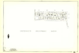
Sheet 26 : University Endowment Lands to Blanca Street and Fourth Avenue to Spanish Banks Beach
Part of City of Vancouver Archives technical and cartographic drawing collection
Item is a section showing the area from the University Endowment Lands to Blanca Street and Fourth Avenue to Spanish Banks Beach. Includes streets, blocks, lots and legal descriptions.
Vancouver (B.C.). Engineering Services

Sheet 29 : Balaclava Street to Maple Street and Fourteenth Avenue to Third Avenue
Part of City of Vancouver Archives technical and cartographic drawing collection
Item is a section showing the area from Balaclava Street to Maple Street and Fourteenth Avenue to Third Avenue. Includes streets, blocks, lots and legal descriptions, and the locations of schools and railways.
Vancouver (B.C.). Engineering Services

Sheet 31 : Oak Street to Main Street and Sixteenth Avenue to Fourth Avenue and False Creek
Part of City of Vancouver Archives technical and cartographic drawing collection
Item is a section showing the area from Oak Street to Main Street and Sixteenth Avenue to Fourth Avenue and False Creek. Includes streets, blocks, lots and legal descriptions, and the locations of parks, schools and railways.
Vancouver (B.C.). Engineering Services

Sheet 35 : Rupert Street to Ardley Avenue and Grandview Highway to Fifth Avenue
Part of City of Vancouver Archives technical and cartographic drawing collection
Item is a section showing the area from Rupert Street to Boundary Road and Grandview Highway to Fifth Avenue. Includes streets, blocks, lots and legal descriptions, and the locations of schools and railways. Also included are streets, blocks and railways in the area from Boundary Road to Ardley Avenue in Burnaby.
Vancouver (B.C.). Engineering Services

Sheet 38 : Nanaimo Street to Rupert Street and Twenty-second Avenue to Grandview Highway
Part of City of Vancouver Archives technical and cartographic drawing collection
Item is a section showing the area from Nanaimo Street to Rupert Street and Twenty-second Avenue to Grandview Highway. Includes streets, blocks, lots and legal descriptions, and the locations of parks, schools and a preventorium (TB hospital).
Vancouver (B.C.). Engineering Services

Sheet 41 : Ontario Street to Inverness Street and Twenty-eighth Avenue to Sixteenth Avenue
Part of City of Vancouver Archives technical and cartographic drawing collection
Item is a section showing the area from Ontario Street to Inverness Street and Twenty-eighth Avenue to Sixteenth Avenue. Includes streets, blocks, lots and legal descriptions, and the locations of parks and schools.
Vancouver (B.C.). Engineering Services

Sheet 42 : Oak Street to Ontario Street and Twenty-eighth Avenue to Sixteenth Avenue
Part of City of Vancouver Archives technical and cartographic drawing collection
Item is a section showing the area from Oak Street to Ontario Street and wenty-eighth Avenue to Sixteenth Avenue. Includes streets, blocks, lots and legal descriptions, and the locations of parks and schools.
Vancouver (B.C.). Engineering Services

Sheet 49 : Arbutus Street to Oak Street and Thirty-third Avenue to Laurier Avenue
Part of City of Vancouver Archives technical and cartographic drawing collection
Item is a section showing the area from Arbutus Street to Oak Street and Thirty-third Avenue to Laurier Avenue. Includes streets, blocks, lots and legal descriptions, and the locations of parks and schools.
Vancouver (B.C.). Engineering Services

Part of City of Vancouver Archives technical and cartographic drawing collection
Item is a section showing the area from Nanaimo Street to Doman Street and Joyce Street and Forty-ninth Avenue to Forty-first Avenue. Includes streets, blocks, lots and legal descriptions, and the locations of parks and schools.
Vancouver (B.C.). Engineering Services

Sheet 59 : Quebec Street to Inverness Street and Forty-seventh Avenue to Thirty-seventh Avenue
Part of City of Vancouver Archives technical and cartographic drawing collection
Item is a section showing the area from Quebec Street to Inverness Street and Forty-seventh Avenue to Thirty-seventh Avenue. Includes streets, blocks, lots and legal descriptions, and the locations of parks, schools and Mountainview Cemetery.
Vancouver (B.C.). Engineering Services
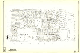
Sheet 77 : Kerr Street to Greenall Avenue and Southeast Marine Drive to Asquith Avenue
Part of City of Vancouver Archives technical and cartographic drawing collection
Item is a section showing the area from Kerr Street to Greenall Avenue and Southeast Marine Drive to Asquith Avenue. Includes streets, blocks, lots and legal descriptions, and the location of parks.
Vancouver (B.C.). Engineering Services

Sheet 79 : Gladstone Street to Kerr Street and North Arm of Fraser River to Bobolink Avenue
Part of City of Vancouver Archives technical and cartographic drawing collection
Item is a section showing the area from Gladstone Street to Kerr Street and North Arm of Fraser River to Bobolink Avenue. Includes streets, blocks, lots and legal descriptions, and the locations of schools, golf courses and the Canadian Pacific Railway.
Vancouver (B.C.). Engineering Services

Sheet 89 : North Arm of Fraser River to Southwest Marine Drive and Barnard Street
Part of City of Vancouver Archives technical and cartographic drawing collection
Item is a section showing the area from North Arm of Fraser River to Southwest Marine Drive and Barnard Street. Includes streets, blocks, lots and legal descriptions.
Vancouver (B.C.). Engineering Services
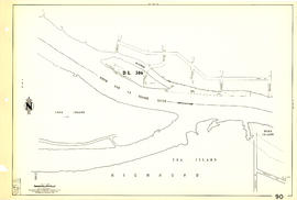
Sheet 90 : Carrington Street to Macdonald Street and Richmond to Celtic Avenue
Part of City of Vancouver Archives technical and cartographic drawing collection
Item is a section showing streets and blocks in the area from Carrington Street to Macdonald Street and Richmond to Celtic Avenue.
Vancouver (B.C.). Engineering Services

City of Vancouver, British Columbia
Part of City of Vancouver Archives technical and cartographic drawing collection
Item is the western half of a map showing city blocks, transportation infrastructure, recreational facilities, hospitals, schools, theatres and other structures are identified. MAP 1036 is the eastern half of this map.
Vancouver (B.C.). Engineering Services

Map showing location of single women receiving assistance by mail
Part of City of Vancouver Archives technical and cartographic drawing collection
Item is a map showing the City of Vancouver covered with annotations to represent the numbers of women in particular areas receiving assistance by mail. Map is a copy of the original and it is not possible to determine the original colour coding.
Vancouver (B.C.). Engineering Services

Sheet 33 : Clark Drive to Nanaimo Street and Thirteenth Avenue to Second Avenue
Part of City of Vancouver Archives technical and cartographic drawing collection
Item is a section showing the area from Clark Drive to Nanaimo Street and Thirteenth Avenue to Second Avenue. Includes streets, blocks, lots and legal descriptions, and the locations of parks, schools and railways.
Vancouver (B.C.). Engineering Services
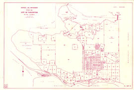
District lot boundaries with the City of Vancouver, British Columbia
Part of City of Vancouver Archives technical and cartographic drawing collection
Item is a map of the City of Vancouver showing district lot boundaries.
Vancouver (B.C.). Engineering Services

Sheet 5 : Stanley Park to Nicola Street and English Bay Beach to Robson Street
Part of City of Vancouver Archives technical and cartographic drawing collection
Item is a section showing the area from Stanley Park to Nicola Street and English Bay Beach to Robson Street. Includes streets, blocks, lots and legal descriptions, and the locations of parks, beaches, schools and golf courses.
Vancouver (B.C.). Engineering Services

Sheet 11 : Wall Street to Rupert Street and McGill Street to Burrard Inlet
Part of City of Vancouver Archives technical and cartographic drawing collection
Item is a section showing the area from Wall Street to Rupert Street and McGill Street to Burrard Inlet. Includes streets, blocks, lots and legal descriptions, and the locations of parks, schools, and railways.
Vancouver (B.C.). Engineering Services

Sheet 13 : Rupert Street to Boundary Road and Eton Street to Burrard Inlet
Part of City of Vancouver Archives technical and cartographic drawing collection
Item is a section showing the area from Rupert Street to Boundary Road and Eton Street to Burrard Inlet. Includes streets, blocks, lots and legal descriptions and schools.
Vancouver (B.C.). Engineering Services
Sheet 15 : Rupert Street to Boundary Road and Kitchener Street to Pender Street
Part of City of Vancouver Archives technical and cartographic drawing collection
Item is a section showing the area from Rupert Street to Boundary Road and Kitchener Street to Pender Street. Includes streets, blocks, lots and legal descriptions. Also shown are streets and blocks in the area from Boundary Road to Carleton Avenue in Burnaby.
Vancouver (B.C.). Engineering Services
Sheet 16 : Rupert Street to Boundary Road and Fifth Avenue to Kitchener Street
Part of City of Vancouver Archives technical and cartographic drawing collection
Item is a section showing the area from Rupert Street to Boundary Road and Fifth Avenue to Kitchener Street. Includes streets, blocks, lots and legal descriptions, and the location of railways.
Vancouver (B.C.). Engineering Services

Sheet 17 : Nanaimo Street to Rupert Street and Charles Street to Pender Street
Part of City of Vancouver Archives technical and cartographic drawing collection
Item is a section showing the area from Nanaimo Street to Rupert Street and Charles Street to Pender Street. Includes streets, blocks, lots and legal descriptions. Includes streets, blocks, lots and legal descriptions, and the locations of parks and schools.
Vancouver (B.C.). Engineering Services
Sheet 24 : Jericho Beach to Balaclava Street and Fourth Avenue to Cameron Avenue
Part of City of Vancouver Archives technical and cartographic drawing collection
Item is a section showing the area from Jericho Beach to Balaclava Street and Fourth Avenue to Cameron Avenue. Includes streets, blocks, lots and legal descriptions, and the locations of parks and beaches.
Vancouver (B.C.). Engineering Services

Sheet 34 : Nanaimo Street to Rupert Street and Grandview Highway to Fifth Avenue
Part of City of Vancouver Archives technical and cartographic drawing collection
Item is a section showing the area from Nanaimo Street to Rupert Street and Fifth Avenue to Grandview Highway. Includes streets, blocks, lots and legal descriptions, and the locations of schools and railways.
Vancouver (B.C.). Engineering Services

Part of City of Vancouver Archives technical and cartographic drawing collection
Item is a section showing the area from Rupert Street to Boundary Road and Wellington Avenue to Twenty-second Avenue. Includes streets, blocks, lots and legal descriptions, and the locations of parks and schools. Also included are streets and blocks in the area from Boundary Road to Carleton Avenue in Burnaby.
Vancouver (B.C.). Engineering Services

Sheet 39 : Kingsway and Nanaimo Street to Rupert Street and Ward Street to Twenty-second Avenue
Part of City of Vancouver Archives technical and cartographic drawing collection
Item is a section showing the area from Kingsway and Nanaimo Street to Rupert Street and Ward Street to Twenty-second Avenue. Includes streets, blocks, lots and legal descriptions, and the locations of parks, schools and railways.
Vancouver (B.C.). Engineering Services
Sheet 46 : Blanca Street to Discovery Street and Sixteenth Avenue to Fourteenth Avenue
Part of City of Vancouver Archives technical and cartographic drawing collection
Item is a section showing the area from Blanca Street to Discovery Street and Sixteenth Avenue to Fourteenth Avenue. Includes streets, blocks, lots and legal descriptions.
Vancouver (B.C.). Engineering Services
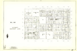
Sheet 47 : Camosun Street to Blenheim Street and Thirty-third Avenue to King Edward Avenue
Part of City of Vancouver Archives technical and cartographic drawing collection
Item is a section showing the area from Camosun Street to Blenheim Street and Thirty-third Avenue to King Edward Avenue. Includes streets, blocks, lots and legal descriptions, and the locations of parks and schools.
Vancouver (B.C.). Engineering Services

Sheet 50 : Oak Street to Ontario Street and Thirty-seventh Avenue to Twenty-eighth Avenue
Part of City of Vancouver Archives technical and cartographic drawing collection
Item is a section showing the area from Oak Street to Ontario Street and Thirty-seventh Avenue to Twenty-eighth Avenue. Includes streets, blocks, lots and legal descriptions, and the locations of parks, schools, hospitals, reservoirs, stadiums and RCMP barracks.
Vancouver (B.C.). Engineering Services

Sheet 51 : Ontario Street to Inverness Street and Thirty-seventh Avenue to Twenty-eighth Avenue
Part of City of Vancouver Archives technical and cartographic drawing collection
Item is a section showing the area from Ontario Street to Inverness Street and Thirty-seventh Avenue to Twenty-eighth Avenue. Includes streets, blocks, lots and legal descriptions, and the locations of parks, schools and Mountainview Cemetery.
Vancouver (B.C.). Engineering Services

Sheet 53 : Inverness Street to Nanaimo Street and Forty-first Avenue to Thirty-second Avenue
Part of City of Vancouver Archives technical and cartographic drawing collection
Item is a section showing the area from Inverness Street to Nanaimo Street and Forty-first Avenue to Thirty-second Avenue. Includes streets, blocks, lots and legal descriptions, and the location of parks.
Vancouver (B.C.). Engineering Services

Part of City of Vancouver Archives technical and cartographic drawing collection
Item is a section showing the area from Nanaimo Street to Joyce Street, Cecil Street and McHardy Street and Forty-first Avenue to Ward Street and Vanness Avenue. Includes streets, blocks, lots and legal descriptions, and the locations of parks and schools.
Vancouver (B.C.). Engineering Services

Part of City of Vancouver Archives technical and cartographic drawing collection
Item is a section showing the area from Cecil Street and McHardy Street to Boundary Road and Kingsway to Monmouth Avenue and Price Street. Includes streets, blocks, lots and legal descriptions, and B.C. Electric Railway line. Also included are streets, blocks and B.C. Electric Railway line in the area from Boundary Road to Patterson Avenue in Burnaby.
Vancouver (B.C.). Engineering Services
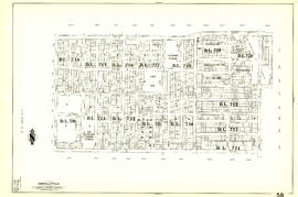
Sheet 58 : Inverness Street to Nanaimo Street and Forty-ninth Avenue to Forty-first Avenue
Part of City of Vancouver Archives technical and cartographic drawing collection
Item is a section showing the area from Inverness Street to Nanaimo Street and Forty-ninth Avenue to Forty-first Avenue. Includes streets, blocks, lots and legal descriptions, and the locations of parks and schools.
Vancouver (B.C.). Engineering Services

Sheet 65 : Camosun Street to Carnarvon Street and Forty-first Avenue to Thirty-third Avenue
Part of City of Vancouver Archives technical and cartographic drawing collection
Item is a section showing the area from Camosun Street to Carnarvon Street and Forty-first Avenue to Thirty-third Avenue. Includes streets, blocks, lots and legal descriptions, and schools.
Vancouver (B.C.). Engineering Services

Part of City of Vancouver Archives technical and cartographic drawing collection
Item is a section showing the area from Musqueam Indian Reserve to Musqueam Park and North Arm, Fraser River to Southwest Marine Drive. Includes streets, blocks, lots and legal descriptions, and parks.
Vancouver (B.C.). Engineering Services

Part of City of Vancouver Archives technical and cartographic drawing collection
Item is a section showing the area from Musqueam Indian Reserve to Macdonald Street and North Arm of the Fraser River to Forty-ninth Avenue. Includes streets, blocks, lots and legal descriptions, and golf courses.
Vancouver (B.C.). Engineering Services