
- COV-S509-: CVA 778-346
- Item
- June 1974
Part of City of Vancouver fonds
Image shows Toft Furs Salon and The Bank of Nova Scotia
123 results with digital objects Show results with digital objects
Part of City of Vancouver fonds
Image shows Toft Furs Salon and The Bank of Nova Scotia

Part of City of Vancouver fonds
Image shows vacant lot in foreground and the back of the Nelson Rooms and the Nothingham Apartments.

Part of City of Vancouver fonds
Image shows vacant lot in foreground, portions the Nelson Rooms and Nothingham Apartments in the 1200 block of Robson Street and the east side of the Sheraton Landmark building.

Part of City of Vancouver fonds
Image shows north side of the Westview Towers apartment building at 860 Jervis Street and apartment buildings in the 1200 block of Haro Street.

Part of Major Matthews collection
Photograph shows a view of the West End and downtown area including houses, courthouse (art gallery) under construction, apartment buildings and churches.

Part of Hubert William Lovell fonds
Photograph was taken in the summer.

A group of railway wives and friends at English Bay
Part of Hubert William Lovell fonds
Photograph was taken in the summer.
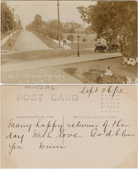
Item is a postcard printed with an image of a residential street in the neighborhood of English Bay. The image also shows automobiles driving by a corner of a park in which people are sitting.
![[Aerial view from English Bay looking north]](/uploads/r/null/d/d/ddde8583daccecc78a9320298ee1ffd98d46ab0f6df0fb5a80a2e9b149444eeb/2b1a9267-8779-4253-95a0-145b5e2029a9-A61396_142.jpg)
[Aerial view from English Bay looking north]
Part of Major Matthews collection
Oblique view showing the Englesea Lodge, the West End, English Bay Beach, Coal Harbour, Deadmans Island, Brockton Point, the western section of Downtown and north Vancouver in the background
![[Aerial view looking north from False Creek]](/uploads/r/null/0/8/081746026b1559c2ace13027d77c668cba79e15800d0ca6ca466b205529e45b3/ce072490-3b01-4b65-8d61-bfaa102cca83-A43247_142.jpg)
[Aerial view looking north from False Creek]
Part of Major Matthews collection
Oblique view showing the West End and Downtown in the background
![[Aerial view looking northwest of the West End and Stanley Park]](/uploads/r/null/8/8/7/887dd5ff7e349fb28124477bf87837887e09eb02be29444c2ab484fb9068ab51/a90b562e-ef47-480e-b13c-5cb26250e139-CVA374-181_142.jpg)
[Aerial view looking northwest of the West End and Stanley Park]
Oblique view showing English Bay, Lost Lagoon, Coal harbour and West Vancouver in the background
![[Aerial view of] English Bay Beach [the West End and Coal Harbour]](/uploads/r/null/b/b/bb7c88b9152ef2f0cd0c703a1f4b8ec3bb0049756fc1b2866fca72704a96421a/73ce5f2f-8ac1-4465-aa81-d5454e7356bb-A23489_142.jpg)
[Aerial view of] English Bay Beach [the West End and Coal Harbour]
Part of Major Matthews collection
Oblique view. Photograph shows apartment buildings west of Denman Street.
![[Aerial view of] Stanley Park Vancouver BC [with] Second Beach Swimming Pool in the foreground.](/uploads/r/null/a/1/a15c959fdf22a475acde3dfbe34911d2ed0e908b82a181e788f415ac76b8aa42/60444948-c365-41d2-8860-876a49aa0885-A23509_142.jpg)
[Aerial view of] Stanley Park Vancouver BC [with] Second Beach Swimming Pool in the foreground.
Part of Major Matthews collection
Oblique view. Photograph shows Second Beach and the Denman Arena.
![[Aerial view of the West End and Coal Harbour from English Bay]](/uploads/r/null/c/4/c40dd1bda7829c0fdb54bdd536310451672acfc5bad79ca7c321ea46afc69f54/b056f458-41bb-4cc2-b6ed-1614b43361ff-A23518_142.jpg)
[Aerial view of the West End and Coal Harbour from English Bay]
Part of Major Matthews collection
Oblique view
![[Aerial view of the West End showing the increase of apartment buildings west of Cardero Street]](/uploads/r/null/9/4/9410444a29ad3e6e13228ba5ad44b40986af7ad70945337641000d03b991a529/ee9fb9e8-21b9-4ca5-a5b6-d28e6d51046e-A25977_142.jpg)
[Aerial view of the West End showing the increase of apartment buildings west of Cardero Street]
Part of Major Matthews collection
Photograph shows oblique view of Lost Lagoon, Stanley Park and Lord Roberts School
![[Aerial view of Vancouver]](/uploads/r/null/1/8/18f00497f9008905bcbff6f62bdc7c5625e266a0ac6b757f9d501d5684921d8a/b6974d97-c2a6-46b1-b55e-581ed03796c9-A23519_142.jpg)
Part of Major Matthews collection
Oblique view. Photograph shows the Westend, Downtown, Coal Harbour and Burrard Inlet.
![[Aerial view of Vancouver]](/uploads/r/null/b/9/b973b9a4143a5316b02e728c35d99e383f27a3db21d8e20aa7bbb459780243bc/3ff38b56-6b36-4c17-bce1-329c97459d29-A66598_142.jpg)
Part of Major Matthews collection
Photograph shows Kitsilano, Kits Point, Kitsilano Beach, R.C.A.F. Equipment Depot, Kitsilano Pool, Burrard Bridge, C.P.R. Kitsilano Trestle, Granville Island, Granville Bridge, Cambie Bridge, False Creek, C.P.R. False Creek Yards, West End, Yaletown, Arbutus Ridge, Shaughnessy, South Cambie, Fairview, Mount Pleasant, Little Mountain Reservoir, Connaught Park, Quilchena Golf Course, Douglas Park, Shaughnessy Heights Golf Course, Queen Elizabeth Park, Royal Canadian Mounted Police Barracks, Shaughnessy Military Hospital, Hillcrest Park, Robertson & Hacket Sawmill, City Yard, West Coast Ship Builders and Athletic Park.
![[Aerial view of] Vancouver B.C. looking east from English Bay](/uploads/r/null/0/3/03edb95dfe9ca891ff17aa9561a8ca736b17e0997af5e4e0c00c4fbce5babe44/9e1c7ace-8758-4763-a19f-d85080d23dbe-A23510_142.jpg)
[Aerial view of] Vancouver B.C. looking east from English Bay
Part of Major Matthews collection
Oblique view. Photograph shows the Englesea Lodge, English Bay Dining Pavillion, Winter Gardens, English Bay Pier and the Sylvia Hotel.
![[Aerial view of Vancouver looking east]](/uploads/r/null/9/3/93309104da24ef0ea4391055c01c783c88d8d52c9939ee604b894d907555df68/564df6c6-3fbe-40b9-bba9-6386ae62ff3c-A23479_142.jpg)
[Aerial view of Vancouver looking east]
Part of Major Matthews collection
Photograph shows the waterfront along Burrard Inlet, Downtown, West End, Pender Street, West Georgia Street and Robson Street.
![[Aerial view of Vancouver looking north]](/uploads/r/null/b/3/b3d3a0fbaf13d79ee1e9bda0902e11d0e4c0033f87fcfd48b7229bb32680e9e4/050796c7-0567-497d-b620-32f8958cbfb9-A23491_142.jpg)
[Aerial view of Vancouver looking north]
Part of Major Matthews collection
Oblique view. Photograph shows Fairview R.C.A.F. Equipment Depot, False Creek, Burrard Bridge, C.P.R. Kitsilano Trestle, Granville (Street) Bridge, Granville Island, the West End, Downtown and Burrard Inlet.
![[Aerial view of Vancouver looking south from Burrard Inlet]](/uploads/r/null/d/1/d168ad5e5af96082c1c6fe04b81895efc9e0f4c037952a04c6f572cc62674f1d/899c29bd-d99f-4ae7-b246-caf98b4806c1-A49667_142.jpg)
[Aerial view of Vancouver looking south from Burrard Inlet]
Oblique view
![[Aerial view of Vancouver showing West and North Vancouver in the distance]](/uploads/r/null/8/d/8d777f00e47e79c44a6ac156af179a087158c26ea0c533480d2a2fb614a2f72e/3d4beb27-2bde-4b39-9fa9-51ad4fca5418-A37529_142.jpg)
[Aerial view of Vancouver showing West and North Vancouver in the distance]
Part of Major Matthews collection
Oblique view showing hand-drawn Burrard, Kitsilano Trestle, Granville, Cambie Street and Lion's Gate Bridges, the causeway through Stanley Park and the street system of Capilano Estates
![[Aerial view of West End and Stanley Park]](/uploads/r/null/4/d/4/4d4e724e2a486490856fe60b67dfeee43429a3860f0dd9901058a9e86f640a07/120e79a6-7374-40bd-b57b-8eaac78f191c-CVA374-180_142.jpg)
[Aerial view of West End and Stanley Park]
Oblique view showing English Bay and North Vancouver in the background
![[Aerial view of West End from English Bay looking east]](/uploads/r/null/3/2/323cc28d66deaf7f42431a4acef03737b7f467d3891feda0bf9f872d1c045ed9/65bad4e7-adbe-48f9-85bf-7305b77abd1d-A23522_142.jpg)
[Aerial view of West End from English Bay looking east]
Part of Major Matthews collection
Oblique view. Photograph shows Beach Avenue and the Iron Workers Memorial Bridge (in the distance), Alexandra Park, English Bay Bathouse.

Aeroplane view of English Bay & the West End of Vancouver, B.C.
Item is a postcard printed with an image of an aerial view of English Bay and the West End. The Promenade Pier, Englesea Lodge, the Sylvia Hotel, and residential as well as commercial buildings are pictured. Stanley Park, Lost Lagoon and Coal Harbour are visible in the background.
![[Alexandra Park]](/uploads/r/null/a/a/aa5a43bde770806111c0ea2763e09c8c4c0f2e7d7f83b4c4e6390acf8746b454/a68477f1-afa8-422b-940e-99edad20867e-A59294_142.jpg)
Part of City of Vancouver fonds

Automobile movement to English Bay
Part of City of Vancouver fonds
Photograph also shows [Isaacs] Pharmacy (1787 Davie Street) on Davie at Denman
Be well participant's handbook
![Blight [- old abandoned cars]](/uploads/r/null/2/4/244d6721672f47a17715e9afc646eaf57cc0f03449b1d53c0a25833553658a72/f1b9613a-55f4-42e2-b3d3-f48644a0f871-A59263_142.jpg)
Part of City of Vancouver fonds
Photograph also shows houses

British Columbia - Vancouver skyline
Item is aerial photograph showing apartment buildings in West End of Vancouver.
![[Buildings along Nelson Street at] Thurlow [Street]](/uploads/r/null/3/1/31f50f28e68e6084aa74e780263c55e7ecb7da618db3ce3548405ac457b9f798/6ab6eb8e-cff2-4dfe-8290-66cc013185cc-A59280_142.jpg)
[Buildings along Nelson Street at] Thurlow [Street]
Part of City of Vancouver fonds
Photograph also shows the Langham Hotel Rooms (1115 Nelson Street)
![[Cityscape view of the] 1000 block Pacific [Street]](/uploads/r/null/8/a/8a59a18378e865a06b1356432c75fb681219f21edfdcdb8558ca1272591fed46/01e90ee3-0a1b-4ca9-963e-b178828b9c93-A59272_142.jpg)
[Cityscape view of the] 1000 block Pacific [Street]
Part of City of Vancouver fonds
Photograph shows houses and apartment buildings
![[Cityscape view of the West End]](/uploads/r/null/b/2/b2feebbabe21912260b44544e0f7be69d3547f49c8fdd8c5911e48cb2462be58/759fe5ab-76e6-4409-979e-5ea7683e9046-A59254_142.jpg)
[Cityscape view of the West End]
Part of City of Vancouver fonds
![[Clearing the site for the Maritime Museum and "St. Roch" at Hadden Park]](/uploads/r/null/7/3/73ebbdeddf0bfb5ed02df474117eff6b9b299030c402792ba3f53b59791bd0f9/4759555b-30eb-4ecd-a1d0-557d84c4b5b0-A24259_142.jpg)
[Clearing the site for the Maritime Museum and "St. Roch" at Hadden Park]
Part of Major Matthews collection
Photograph shows the Crystal Pool, buildings and houses on Beach Avenue.
![[Clearing the site for the Maritime Museum and "St. Roch" at Hadden Park, Kitsilano Beach]](/uploads/r/null/9/9/99330cf4e78949ad1c1b0d5acc228a536d7cd3b379bf75310ca42fb07657cfcb/c362f57a-f2f2-4adb-8a72-8f22029c0dda-A24260_142.jpg)
[Clearing the site for the Maritime Museum and "St. Roch" at Hadden Park, Kitsilano Beach]
Part of Major Matthews collection
Photograph shows the Crystal Pool, buildings and houses on Beach Avenue.

English Bay Beach, English Bay Pier and Beach Avenue
Item is a photograph of a rocky portion of English Bay Beach and the English Bay Pier, looking east towards English Bay. Beach Avenue is visible on the other side of the pier, in the background.

English Bay Beach, English Bay Pier and Englesea Lodge
Item is a photograph of a sandy portion of English Bay Beach and the English Bay Pier, looking west towards the pier and Englesea Lodge behind it.
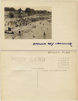
![[English Bay Beach, Vancouver]](/uploads/r/null/2/e/1/2e143b9a8c8415a330bbc063ae50da4e5bcf04f1998b3091ca15958406f83119/59a7cd79-c029-425c-b857-c18d495e5bf7-AM1052P-31_142.jpg)
[English Bay Beach, Vancouver]
Item is a postcard printed with an image of the beach at English Bay, taken from the pier looking southeast. A bathhouse, other buildings, and bathers are pictured.

English Bay Beach, Vancouver, B.C.
Item is a postcard printed with an image of the beach at English Bay, looking north. Shown in this image are bathers on the beach; the slide and diving platform; the English Bay Bathhouse; the Sylvia Hotel; houses; the Englesea Lodge; a dancing pavilion; and Stanley Park. The Promenade Pier had been demolished at the time that this photograph was taken.

Item is a postcard printed with an image of the beach at English Bay, viewed from the Promenade Pier looking southeast toward bathhouses and other buildings. Bathers and the slide and diving platform are also pictured.
![[English Bay, showing beach and buildings at corner of Davie Street and Denman Street]](/uploads/r/null/6/5/65edc8575385902e8a5621612171f9a7142c85127377b4ed763926a01c7543ee/0fc7d193-f7d6-4cd2-b6bb-1493b6a84a37-CVA258-1_142.jpg)
[English Bay, showing beach and buildings at corner of Davie Street and Denman Street]
Part of Hubert William Lovell fonds
Photograph was taken in the summer. Pantages café is visible.
Item is a postcard printed with an image of bathers at the beach at English Bay, taken from the Promenade Pier looking southeast. A bathhouse and other buildings are pictured.

Item is a postcard printed with an image of the beach at English Bay, viewed from the Promenade Pier looking west. Pictured in the image are bathers in the water; bathers crowding the slide and diving platform and the beach; a bathhouse; and residential buildings. This postcard includes personal correspondence. Sent to J.H. Schofield of Trail, B.C.
Subseries consists of two albums of photographs documenting the restoration of Barclay Manor (1447 Barclay Street, formerly referred to as Park Site 19), a once gracious Edwardian residence turned rooming house. Also documented is the structural restoration of the neighbouring Weeks house (1459 Barclay Street). Some textual information is included in the albums.
![[Fairview looking west across False Creek]](/uploads/r/null/5/3/530c1602976afb68dba7c39f098a0a2dd5b251f4f37cb95836fc30f1f5877280/8ef64e7f-ca79-41ee-b3cc-070bc0f90b28-A25939_142.jpg)
[Fairview looking west across False Creek]
Part of Major Matthews collection
Panoramic view showing the False Creek Indian Reserve, Granville and C.P.R. Kitsilano Trestle bridges and Edward Chapman's residence.
![[House at] 1373 Barclay [Street]](/uploads/r/null/2/9/29f904d044789fd583796793a14f431400a1894abc5902be1f9ce707cbc2f496/4fc81b99-945d-45e5-a926-d2f2f6e62bdf-A59275_142.jpg)
[House at] 1373 Barclay [Street]
Part of City of Vancouver fonds
![[House at] 1443 Robson [Street] and [house at] 1449 Robson [Street]](/uploads/r/null/2/4/24b711a5cdb5a39cb8761f130d05e65964ab5a8cd5c46169751feb4d5c61fe11/7ee86444-f9c0-4a09-b298-3194463f36f0-A59270_142.jpg)
[House at] 1443 Robson [Street] and [house at] 1449 Robson [Street]
Part of City of Vancouver fonds
![[Houses along the] 1400 bl[ock] Comox [Street]](/uploads/r/null/8/a/8a2d8eacad93b11d5e5cddc257099983953d0f8ec79e1f8b481073abbda6b32d/992b82b0-c008-43b3-83fd-2aae3abfd1c2-A59273_142.jpg)
[Houses along the] 1400 bl[ock] Comox [Street]
Part of City of Vancouver fonds
![[Houses along] Thurlow [Street] near Nelson [Street]](/uploads/r/null/a/2/a2771b8d1114e2054256d837e78a7839b4d49b9bd8b88c42f3e132ab980219a5/5af3315d-1654-445b-a2e9-c80d26e40c69-A59274_142.jpg)
[Houses along] Thurlow [Street] near Nelson [Street]
Part of City of Vancouver fonds
![[Houses in the] 1300 block Burnaby [Street]](/uploads/r/null/9/b/9bdae51807d4be5f3f90fe220e5e7b18199987c8dadb394d50ffbd97f7fb6646/f6b6fc43-c62f-4366-8592-5e3edcba2c3f-A59279_142.jpg)
[Houses in the] 1300 block Burnaby [Street]
Part of City of Vancouver fonds