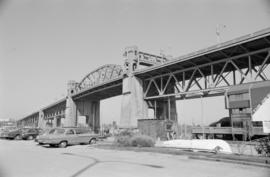
![[Burrard Street Bridge, 3 of 3]](/uploads/r/null/1/d/7/1d744db11b4d7423fbffc805972c5694e3a1fab315ac73ae3ae3f7f6205014ae/620998a7-dd5f-4266-ae95-45faccfd905f-CVA1095-15069_142.jpg)
[Burrard Street Bridge, 3 of 3]
- COV-S644-: CVA 1095-15069
- Item
- [between 1969 and 1976]
Part of City of Vancouver fonds
27 results with digital objects Show results with digital objects
[Burrard Street Bridge, 3 of 3]
Part of City of Vancouver fonds
![[Burrard Street Bridge, 2 of 3]](/uploads/r/null/b/7/1/b71695b76d79c18cfe3eca173064b375f56c794b93c98642faf7bf8753a0845a/703e5e4b-b9be-424d-a557-3bddc16cdf6b-CVA1095-15068_142.jpg)
[Burrard Street Bridge, 2 of 3]
Part of City of Vancouver fonds
![[Burrard Street Bridge, 1 of 3]](/uploads/r/null/8/2/7/8272b00c7778bee0357fc7fdaeb93e9009fb5d4ad2b00865251e9730d3fd3666/d74bdc73-21ac-4cbe-a77f-aefb7ea6e743-CVA1095-15066_142.jpg)
[Burrard Street Bridge, 1 of 3]
Part of City of Vancouver fonds
![[Keefer Street parking lot, 2 of 2]](/uploads/r/null/8/8/c/88c9b96a18916fc7c901bd97e5072ad287046681b615277fb36dc4fe3a3953ac/5ec0cbf6-ecd6-4f1c-b1a4-8552746194b6-CVA1095-08566_142.jpg)
[Keefer Street parking lot, 2 of 2]
Part of City of Vancouver fonds
Item is a photograph that depicts a parking lot with a sign for the Vanport Hotel visible behind it.
![[Keefer Street parking lot, 1 of 2]](/uploads/r/null/b/8/f/b8fcc8fbb02c370b4e1b9f8b5fdb4129ffad0bf1fe29aa70b6a164f47043fb97/e35ef3f6-f7b3-4e89-8b5b-52f2bc7ba9c9-CVA1095-08565_142.jpg)
[Keefer Street parking lot, 1 of 2]
Part of City of Vancouver fonds
Item is a photograph that depicts a parking lot in front of an overpass.
![[1010 Beach Avenue - Essington Seafood Restaurant]](/uploads/r/null/8/d/7/8d7bc1e891340ef66dcf7e81148ced311fe0f2875e0f2ea854fb9304e71b8bf3/d8ba7a78-1193-4249-9a71-8ef9f93b3d8c-CVA1095-06514_142.jpg)
[1010 Beach Avenue - Essington Seafood Restaurant]
Part of City of Vancouver fonds
![[North end of Burrard Bridge]](/uploads/r/null/8/8/d/88df8cb35881fa60d8534635db1ddc94dbaf003a3dd6383e9fad02e549501cdb/3fbd50bd-7899-4556-acc2-f2f3966c8e4e-CVA1095-01167_142.jpg)
Part of City of Vancouver fonds
Item is a photograph that depicts a view looking south over the Burrard Bridge.
![[Dedication plaque for the construction of the Burrard Bridge]](/uploads/r/null/7/7/d/77d318c0c5187a095acee61542bcf9469ba4c742074f0269c3523cc19cccf652/4fbaafd9-5f36-46f0-9cdd-859773a27632-CVA1095-01166_142.jpg)
[Dedication plaque for the construction of the Burrard Bridge]
Part of City of Vancouver fonds
![Seens [scenes] of Van[couver], Capilano, Stanley Park](/uploads/r/null/1/3/b/13bc9013786c37378f12ed8a438df461807fab1a389b9e9c2896f171e1c9e03f/b640bf28-47ef-404b-9944-eeb4bd5eeda9-2012-033_142.jpg)
Seens [scenes] of Van[couver], Capilano, Stanley Park
Part of City of Vancouver Archives sound recording and moving image collection
Item is a film showing various scenes around Vancouver. The first half of this film documents a Gray Line Tours bus trip through Vancouver and second half contains scenes showing landmarks of Vancouver and surrounding areas. Film contains footage showing: Empress of Japan Figurehead in Stanley Park, U.B.C., Chinatown, Hotel Georgia, Lion's Gate Bridge, Court House, Capilano Suspension Bridge, Capilano Golf and Country Club, Prospect Point, Stanley Park, views of downtown and North Shore Mountains from Little Mountain, City Hall, sailboats in Burrard Inlet, and Swimmers at Kits Beach.
File consists of photographs taken by Cuthbert of streets and buildings in Vancouver's downtown core, the collapse of the Second Narrows Bridge, and exterior views of the former F. Ronald Graham home, 1955-1958, 1967, 1971; as well as photographs collected by Cuthbert including the Burrard Bridge, 1932, group portrait of the Southlands Riding Club for which Cuthbert and his father, Robert G. Cuthbert, were members, 1945, and the the site of his father's veterinary practice at different locations on West 4th Avenue, 1925 - ca. 1964.
Cuthbert, Robert

Part of Yaletown Productions Inc. fonds
This item consists of raw footage featuring B.C./Expo 86 aerials; shot in 35mm and transferred to one inch tape. Original negative no longer exists and only video footage survives. Some of this material was used in Yaletown Production's video postcard series. Includes nighttime footage of downtown Vancouver.
Part of City of Vancouver fonds
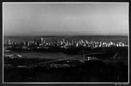
View of Lions Gate Bridge, downtown and West End from West Vancouver

View of Lions Gate Bridge, downtown and West End from West Vancouver
![Stanley Park and [North] Shore - Horseshoe Bay and Malahat Hwy. - Mr. and Mrs. Tom Fowlers to Vic...](/uploads/r/null/5/c/6/5c697861893c630042fb5a2fac0aacaf294c63237840781ebc9a04eee647792b/7acd8a3b-1f6c-490c-8ded-ee944db96cb5-2013-033_142.jpg)
Part of Harry Lin Chin fonds
Item is a film showing the view from inside an automobile travelling the road along the Stanley Park causeway and going across the Lions Gate Bridge towards the North Shore. Film contains scenes from within the car, the Horseshoe Bay ferry terminal, aboard the ferry, scenes along the Malahat highway, Duncan, Ladysmith, Malahat Lookout, Victoria Auto Court Motel. The film concludes with a return trip to Vancouver, driving across the Granville Street Bridge, through downtown and across a viaduct.

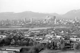
Downtown cityscape over Fairview and False Creek
Part of City of Vancouver fonds
Item part is a photograph of downtown Vancouver over Fairview and False Creek. The Granville Street Bridge and the Burrard Street Bridge are visible at the far left.

Downtown cityscape over Mount Pleasant, Fairview, and False Creek
Part of City of Vancouver fonds
Item part is a photograph of downtown Vancouver, including a view down Cambie Street across the Cambie Street Bridge, and adjacent neighborhoods in Fairview and Mount Pleasant.

Downtown cityscape over Mount Pleasant, Fairview, and False Creek
Part of City of Vancouver fonds
Item part is a photograph of downtown Vancouver, including a view down Cambie Street across the Cambie Street Bridge, and adjacent neighborhoods in Fairview and Mount Pleasant.
Downtown cityscape over Mount Pleasant, Fairview, and False Creek
Part of City of Vancouver fonds
Item part is a photograph of downtown Vancouver, including a view down Cambie Street across the Cambie Street Bridge, and adjacent neighborhoods in Fairview and Mount Pleasant.

Downtown cityscape over Mount Pleasant, Fairview, and False Creek
Part of City of Vancouver fonds
Item part is a photograph of downtown Vancouver, including a view down Cambie Street across the Cambie Street Bridge, and adjacent neighborhoods in Fairview and Mount Pleasant.

Downtown cityscape over Mount Pleasant, Fairview, and False Creek
Part of City of Vancouver fonds
Item part is a photograph of downtown Vancouver, including a view down Cambie Street across the Cambie Street Bridge, and adjacent neighborhoods in Fairview and Mount Pleasant.

Downtown cityscape over Mount Pleasant, Fairview, and False Creek
Part of City of Vancouver fonds
Item part is a photograph of downtown Vancouver, including a view down Cambie Street across the Cambie Street Bridge, and adjacent neighborhoods in Fairview and Mount Pleasant. The Granville Street Bridge and the Burrard Street Bridge are visible at the far left.
Downtown cityscape over Mount Pleasant, Fairview, and False Creek
Part of City of Vancouver fonds
Item part is a photograph of downtown Vancouver, including a view down Cambie Street across the Cambie Street Bridge, and adjacent neighborhoods in Fairview and Mount Pleasant.

Downtown cityscape over Mount Pleasant, Fairview, and False Creek
Part of City of Vancouver fonds
Item part is a photograph of downtown Vancouver, including a view down Cambie Street across the Cambie Street Bridge, and adjacent neighborhoods in Fairview and Mount Pleasant.

Downtown cityscape over Mount Pleasant, Fairview, and False Creek
Part of City of Vancouver fonds
Item part is a photograph of downtown Vancouver, including a view down Cambie Street across the Cambie Street Bridge, and adjacent neighborhoods in Fairview and Mount Pleasant.

Downtown cityscape over Mount Pleasant, Fairview, and False Creek
Part of City of Vancouver fonds
Item part is a photograph of downtown Vancouver, including a view down Cambie Street across the Cambie Street Bridge, and adjacent neighborhoods in Fairview and Mount Pleasant.
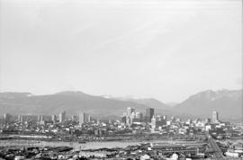
Vancouver Cityscapes - Downtown, Fairview, Mount Pleasant
Part of City of Vancouver fonds
Item is a set of negatives of cityscape photographs taken mostly from the upper floors of the Plaza 500 Hotel & Convention Centre at 500 W. West 12th Avenue, at the intersection of West 12th Avenue and Cambie Street, looking north. The subject material of the photographs is predominantly downtown Vancouver, the North Shore Mountains, False Creek, and the Fairview and Mount Pleasant neighbourhoods. This set contains the raw photographs from the roll the photographer shot in their original order. The associated contact sheet has selection marks for frames 16, 21, 23, and 25.