- AM1594-: MAP 1171
- Item
- 1955
Part of City of Vancouver Archives technical and cartographic drawing collection
Map shows lot numbers, lot boundaries and major roads in the municipality of Burnaby.
39 results with digital objects Show results with digital objects
Part of City of Vancouver Archives technical and cartographic drawing collection
Map shows lot numbers, lot boundaries and major roads in the municipality of Burnaby.

Part of City of Vancouver Archives technical and cartographic drawing collection
Item is a street map of the City of Vancouver showing streets, schools, hospitals, parks and golf courses. A street index is included. A dial would have been attached at the centre of the map, but the dial has since been removed.

Part of City of Vancouver Archives technical and cartographic drawing collection
Map shows Vancouver from West Boulevard to Boundary Road and from Burrard Inlet to the Fraser River. A portion of North Vancouver is also shown. Streets, parks, schools and golf courses are identified. Map joins with MAP 575 to create a complete map of the City of Vancouver.

Part of City of Vancouver Archives technical and cartographic drawing collection
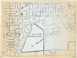
Map shows Vancouver from the University Endowment Lands to South Granville Street and from English Bay to the Fraser River. Streets, parks, schools and golf courses are identified. Map joins with MAP 574 to create a map of the entire City of Vancouver.

Part of City of Vancouver Archives technical and cartographic drawing collection
Part contains a street map of Vancouver showing streets, block numbers, bus routes, railway lines, boundaries, private roads and hospitals. The map includes a dial (a numbered circle, a paper indicator, a grid of block numbers and a street index used to find locations in Vancouver). A small inset shows the streets surrounding Queen Elizabeth Park, which are obscured on the main map where the indicator is attached.

Dial map of Greater Vancouver and suburbs
Part of City of Vancouver Archives technical and cartographic drawing collection
Part contains a street map of Vancouver, Burnaby, New Westminster, West Vancouver and North Vancouver showing block numbers, street car, bus, and railway lines, parks and hospitals. Map includes two dials (a numbered circle, a paper indicator, a grid of block numbers and a street index used to find locations). A small inset map shows the Capitol Hill/Scenic Park area of Burnaby in greater detail.

Dial map of Greater Vancouver and suburbs
Part of City of Vancouver Archives technical and cartographic drawing collection
Part contains a street map of Vancouver, Burnaby, New Westminster, West Vancouver, and North Vancouver showing railways, hospitals, parks and block numbers. The map includes two dials (numbered circles, paper indicators, a grid of block numbers and a street index used to find locations).
Dial map of the city of Vancouver including the adjacent municipalities
Part of City of Vancouver Archives technical and cartographic drawing collection
Item is a street map showing Vancouver, Burnaby, New Westminster, West Vancouver and North Vancouver on one side and the University Endowment Lands, Surrey, Maillardville, Lulu Island and Sea Island on the other.

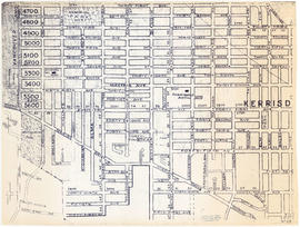
Map of Burnaby and New Westminster, British Columbia
Part of City of Vancouver Archives technical and cartographic drawing collection
Part consists of a street map of Burnaby and New Westminster, information on bus and street car routes, and text advertising the products and services of the Dominion Map and Blueprint Company.

Part of City of Vancouver Archives technical and cartographic drawing collection
Part consists of a map showing major roadways in the Lower Mainland and the Fraser Valley from Vancouver to Chilliwack, and lists of Vancouver businesses, schools, public buildings, hospitals, bathing beaches, fire halls, and golf and country clubs. Part includes text advertising the products and services of the Dominion Map and Blueprint Company.

Part of City of Vancouver Archives technical and cartographic drawing collection
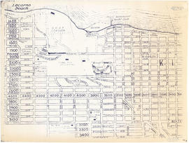
Part contains street maps of Lulu Island and Sea Island, Delta, Surrey, Langley, and Maillardville, tourist information about Vancouver, and text advertising the products and services of the Dominion Map and Blueprint Company.

Part of City of Vancouver Archives technical and cartographic drawing collection
Part contains street maps of the University Endowment Lands, Surrey, Maillardville, Lulu Island and Sea Island, tourist information about Vancouver, and text advertising the products and services of the Dominion Map and Blueprint Company.
Sectional map and street directory of Vancouver : Dial map of the city of Vancouver
Part of City of Vancouver Archives technical and cartographic drawing collection
Item is a street map showing Vancouver on one side and Burnaby and New Westminster on the other, as well as information on street car and bus routes, and text advertising the products and services of the Dominion Map and Blueprint Company.
Part of City of Vancouver Archives technical and cartographic drawing collection
Item is a street map showing Vancouver, Burnaby, New Westminster, West Vancouver, and North Vancouver on one side and the Lower Mainland from Vancouver to Chilliwack on the other. Item includes lists of businesses, schools, public buildings, hospitals, bathing beaches, fire halls, and golf and country clubs, as well as text advertising the products and services of the Dominion Map and Blueprint Company.
Part of City of Vancouver Archives technical and cartographic drawing collection
Item is a street map showing Vancouver, Burnaby, New Westminster, West Vancouver and North Vancouver on one side and Delta, Surrey, Langley, Maillardville, Lulu Island and Sea Island on the other.

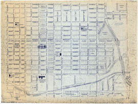
Sheet 1 : Boundary Road to Burrard Inlet to Templeton Drive to Charles Street
Part of City of Vancouver Archives technical and cartographic drawing collection
Item is a reproduction of a section of an unknown map.
Sheet 10 : Clarendon Street to Forty-ninth Avenue to St. George Street to Fraser River
Part of City of Vancouver Archives technical and cartographic drawing collection
Item is a reproduction of a section of an unknown map.
Sheet 11 : Clark Drive to Atlantic Street to Cambie Stree to East Sixteenth Avenue
Part of City of Vancouver Archives technical and cartographic drawing collection
Item is a reproduction of a section of an unknown map.
Part of City of Vancouver Archives technical and cartographic drawing collection
Item is a reproduction of a section of an unknown map.

Sheet 13 : Ross Street to Twenty-ninth Avenue to Heather Street to Forty-ninth Avenue
Part of City of Vancouver Archives technical and cartographic drawing collection
Item is a reproduction of a section of an unknown map.

Sheet 14 : Prince Albert Street to Forty-ninth Avenue to Laurel Street to Kent Avenue
Part of City of Vancouver Archives technical and cartographic drawing collection
Item is a reproduction of a section of an unknown map.

Sheet 15 : Columbia Street to Drake Street to Cypress Street to West Eighteenth Avenue
Part of City of Vancouver Archives technical and cartographic drawing collection
Item is a reproduction of a section of an unknown map.

Sheet 16 : Cambie Street to West Fifteenth Avenue to Arbutus Street to Thirty-fifth Avenue
Part of City of Vancouver Archives technical and cartographic drawing collection
Item is a reproduction of a section of an unknown map.
Sheet 17 : Oak Street to Connaught Street to Elm Street to West 50th Avenue
Part of City of Vancouver Archives technical and cartographic drawing collection
Item is a reproduction of a section of an unknown map.

Sheet 18 : Laurel Street to West Forty-ninth Avenue to Marine Crescent to Seventieth Avenue
Part of City of Vancouver Archives technical and cartographic drawing collection
Item is a reproduction of a section of an unknown map.

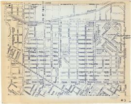
Sheet 19 : Cambie Street to Fifty-seventh Avenue to Arbutus Street to Fraser River
Part of City of Vancouver Archives technical and cartographic drawing collection
Item is a reproduction of a section of an unknown map.
Sheet 2 : Boundary Road to Venables Street to Lakewood Street to East Fourteenth Avenue
Part of City of Vancouver Archives technical and cartographic drawing collection
Item is a reproduction of a section of an unknown map.

Sheet 20 : Granville Street to English Bay to Trutch Street to West Sixteenth Avenue
Part of City of Vancouver Archives technical and cartographic drawing collection
Item is a reproduction of a section of an unknown map.

Sheet 21 : Cypress Street to West Fifteenth Avenue to Highbury Street to Thirty-fifthe Avenue
Part of City of Vancouver Archives technical and cartographic drawing collection
Item is a reproduction of a section of an unknown map.
Sheet 22 : Vine Street to Thirty-first Avenue to Camosun Street to Fifty-first Avenue
Part of City of Vancouver Archives technical and cartographic drawing collection
Item is a reproduction of a section of an unknown map.

Sheet 23 : Vine Street to Forty-first Avenue to Salish Drive to Fraser River
Part of City of Vancouver Archives technical and cartographic drawing collection
Item is a reproduction of a section of an unknown map.
Sheet 24 : Balaclava Street to English Bay to Tolmie Street to Nineteenth Avenue
Part of City of Vancouver Archives technical and cartographic drawing collection
Item is a reproduction of a section of an unknown map.

Sheet 25 : Balaclava Street to Fifteenth Avenue to Blanca Street to Thirty-fifth Avenue
Part of City of Vancouver Archives technical and cartographic drawing collection
Item is a reproduction of a section of an unknown map.

Sheet 26 : Highbury Street to English Bay to Tasmania Boulevard to Seventeenth Avenue
Part of City of Vancouver Archives technical and cartographic drawing collection
Item is a reproduction of a section of an unknown map.

Sheet 28 : Main Street to Twenty-ninth Avenue to Granville Street to Fiftieth Avenue
Part of City of Vancouver Archives technical and cartographic drawing collection
Item is a reproduction of a section of an unknown map.
Sheet 3: Boundary Road to East Broadway to Lakewood Street to Galt Street
Part of City of Vancouver Archives technical and cartographic drawing collection
Item is a reproduction of a section of an unknown map.
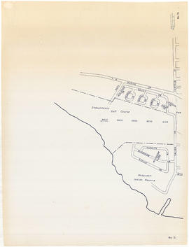
Sheet 31 : Camosun Street to Shaughnessy golf course to Fraser River to Salish Drive
Part of City of Vancouver Archives technical and cartographic drawing collection
Item is a reproduction of a section of an unknown map.
Sheet 4 : Boundary Road to 24th Avenue to Victoria Drive to Forty-ninth Avenue
Part of City of Vancouver Archives technical and cartographic drawing collection
Item is a reproduction of a section of an unknown map.
Sheet 5 : Boundary Road to Forty-ninth Avenue to Victoria Drive to Kent Avenue
Part of City of Vancouver Archives technical and cartographic drawing collection
Item is a reproduction of a section of an unknown map.
Sheet 6 : Penticton Street to Burrard Inlet to Princess Avenue to William Street
Part of City of Vancouver Archives technical and cartographic drawing collection
Item is a reproduction of a section of an unknown map.

Sheet 7 : Penticton Street to East Georgia Street to Carolina Street to Twelfth Avenue
Part of City of Vancouver Archives technical and cartographic drawing collection
Item is a reproduction of a section of an unknown map.

Sheet 8 : Nanaimo Street to Twelfth Avenue to St. George Street to Thirty-third Avenue
Part of City of Vancouver Archives technical and cartographic drawing collection
Item is a reproduction of a section of an unknown map.

Sheet 9 : St. Margaret Street to Twenty-ninth Avenue to St. George St. to East Forty-ninth Avenue
Part of City of Vancouver Archives technical and cartographic drawing collection
Item is a reproduction of a section of an unknown map.
Part of City of Vancouver Archives technical and cartographic drawing collection
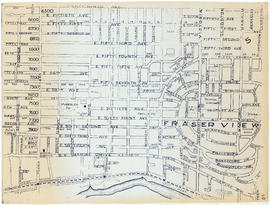
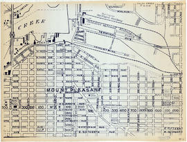
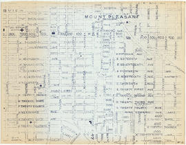
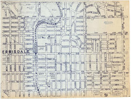
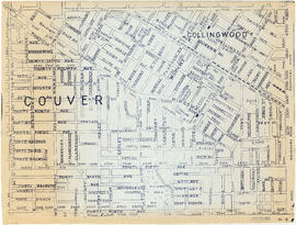
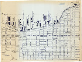
File consists of reproductions of sections of at least three different street maps of Vancouver. The sections show streets, railways, schools and main features of interest.