[Wreaths placed by stairs to park building during opening of Memorial Park]
[Wooden shed and gate]
[Wooden bridge over a ditch on a farm south of Marine Drive]
[Women and girls sitting on the front steps of the S.B. Bennett house at 6306 Prince Albert Street, South Vancouver]
Winram Block Corner 17th Avenue and Main Street, Vancouver, B.C.
[Windsor Theatre at 25th Avenue and Main Street]
[Welcome arch]
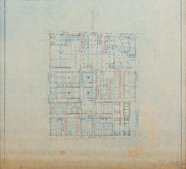
Water tanks at Municipal Hall
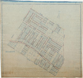
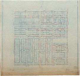
Water service map of South Vancouver : Wales Street to Churchill Street (Rupert Street) and New Westminster Road (Kingsway) to 46th Avenue (45th Avenue)
Water service map of South Vancouver : Vivian Street to Kerr Street and 56th Avenue (54th Avenue) to 67th Avenue (65th Avenue)
Water service map of South Vancouver : Vivian Street to Kerr Street and 46th Avenue (45th Avenue) to 56th Avenue (54th Avenue)
Water service map of South Vancouver : Vivian Street to Doman Street and 67th Avenue (65th Avenue) to North Arm of Fraser River
Water service map of South Vancouver : Victoria Drive to Wales Street and 35th Avenue (34th Avenue) to 46th Avenue (45th Avenue)
Water service map of South Vancouver : Victoria Drive to Vivian Street and 56th Avenue (54th Avenue) to 67th Avenue (65th Avenue)
Water service map of South Vancouver : Victoria Drive to Vivian Street and 46th Avenue (45th Avenue) to 56th Avenue (54th Avenue)
Water service map of South Vancouver : Victoria Drive to Vivan Street and 67th Avenue (65th Avenue) to North Arm of Fraser River
Water service map of South Vancouver : Victoria Drive to Slocan Street and 27th Avenue to 35th Avenue (34th Avenue)
Water service map of South Vancouver : Tyne Street to Park Street (Boundary Road) and Vanness Avenue to 46th Avenue (45th Avenue)
Water service map of South Vancouver : Tyne Street to Park Street (Boundary Road) and 56th Avenue (54th Avenue) to 67th Avenue (65th Avenue)
Water service map of South Vancouver : Tyne Street to Park Street (Boundary Road) and 46th Avenue (45th Avenue) to 56th Avenue (54th Avenue)
Water service map of South Vancouver : Slocan Street to Rupert Street and Vanness Avenue to School Road (School Avenue)
Water service map of South Vancouver : Rupert Street to Tyne Street and Vanness Avenue to School Road (School Avenue)
Water service map of South Vancouver : Point Grey boundary to Ontario Street and River Avenue (Marine Drive S.W.) to North Arm of Fraser River
Water service map of South Vancouver : Ontario Street to Fraser Street and River Avenue (Marine Drive) to North Arm of Fraser River
Water service map of South Vancouver : Ontario Street to Fraser Street and King Edward Avenue to 34th Avenue (33rd Avenue)
Water service map of South Vancouver : Ontario Street to Fraser Street and 61st Avenue (59th Avenue) to River Street (Marine Drive S.E.)
Water service map of South Vancouver : Ontario Street to Fraser Street and 51st Avenue (49th Avenue) to 61st Avenue (59th Avenue)
Water service map of South Vancouver : Ontario Street to Fraser Street and 43rd Avenue (41st Avenue) to 51st Avenue (49th Avenue)
Water service map of South Vancouver : Ontario Street to Fraser Street and 33rd Avenue to 41st Avenue
Water service map of South Vancouver : McHardy Street to Park Street (Boundary Road) and Government Street (29th Avenue) to Vanness Avenue
Water service map of South Vancouver : Knight Street to Victoria Drive and 61st Avenue (59th Avenue) to North Arm of Fraser River
Water service map of South Vancouver : Knight Street to Victoria Drive and 51st Avenue (49th Avenue) to 61st Avenue (59th Avenue)
Water service map of South Vancouver : Knight Street to Victoria Drive and 43rd Avenue (41st Avenue) to 51st Avenue (49th Avenue)
Water service map of South Vancouver : Knight Street to Victoria Drive and 34th Avenue (33rd Avenue) to 43rd Avenue (41st Avenue)
Water service map of South Vancouver : Knight Street to Victoria Drive and 22nd Avenue to 34th Ave (33rd Avenue)
Water service map of South Vancouver : Knight Street to Commercial Street and 15th Avenue (16th Avenue) to 22nd Avenue
Water service map of South Vancouver : Kerr Street to Tyne Street and 56th Avenue (54th Avenue) to 67th Avenue (65th Avenue)
Water service map of South Vancouver : Kerr Street to Tyne Street and 46th Avenue (45th Avenue) to 56th Avenue (54th Avenue)
Water service map of South Vancouver : Fraser Street to Sherbrooke Street and 43rd Avenue (41st Avenue) to 51st Avenue (49th Avenue)
Water service map of South Vancouver : Fraser Street to Knight Street and 61st Avenue (59th Avenue) to North Arm of Fraser River
Water service map of South Vancouver : Fraser Street to Knight Street and 51st Avenue (49th Avenue) to 61st Avenue (59th Avenue)
Water service map of South Vancouver : Fraser Street to Knight Street and 34th Avenue (33rd Avenue) to 43rd Avenue (41st Avenue)
Water service map of South Vancouver : Fraser Street to Knight Street and 25th Avenue to 34th Avenue (33rd Avenue)
Water service map of South Vancouver : Doman Street to Park Street (Boundary Road) and 67th Avenue (65th Avenue) to North Arm of Fraser River
Water service map of South Vancouver : Commercial Street to Nanaimo Street and Trout Lake to 27th Avenue
Water service map of South Vancouver : Churchill Street (Rupert Street) to Tyne Street and School Road (School Avenue) to 46th Avenue (45th Avenue)
Water service map of South Vancouver : Bridge Street (Cambie Street) to Main Street and 16th Avenue to 26th Avenue
Water service map of South Vancouver : Ash Street to Ontario Street and 61st Avenue (59th Avenue) to River Avenue (Marine Drive)
Water service map of South Vancouver : area bounded by Vanness Avenue, Government Street (29th Avenue), and McHardy Street
[View of three houses behind bushes and small trees]
![[Wreaths placed by stairs to park building during opening of Memorial Park]](/uploads/r/null/f/4/f4ac865bcb156bc89e4abde8f0d8891554d6332f27e89e369161b6bd51157fa3/0094b320-4c4d-4b6b-b67b-fdb46851daba-A09364_142.jpg)
![[Wooden shed and gate]](/uploads/r/null/f/d/fd721bdc65b9b81eeff8d6c740c09fe24c24bf369991a113e6a9d8d9add11f50/b3bf86db-ae6a-4630-b84d-df994e852dac-A19331_142.jpg)
![[Wooden bridge over a ditch on a farm south of Marine Drive]](/uploads/r/null/7/d/7d269df71d3de1b2a715fc684f4922d94e74957f8d08a6e7939723299dff07e6/1076224d-c4f5-4c3d-a28c-94a54a46194f-A19336_142.jpg)


![[Windsor Theatre at 25th Avenue and Main Street]](/uploads/r/null/9/4/94927d80accf8addfad8f38669e850d23da8ef84133cf3485e39620dde7e6caa/2025dbd7-871e-4bc5-9ed1-10f8eb641891-A08949_142.jpg)
![[Welcome arch]](/uploads/r/null/e/2/e232e569fd9eb66efa5378e9c0726bd211737ee8d51c68a990ba603b28716756/5c39a2f7-6b63-47de-9b7a-46e6c70af1d6-A19275_142.jpg)


![[View of three houses behind bushes and small trees]](/uploads/r/null/4/5/45c57391176424eff0914a0e72007dbc0b4064d5acc8b0e7db169f39d43ce10f/0b1e2fbd-0c4a-4bff-9a08-dda3fda4fec1-A07795_142.jpg)