
Wrigley's offical arrow city map : Greater Vancouver and New Westminster : map cover

Wrigley's new map of Vancouver and Lower Mainland

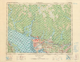
Wrigley's 1930 map of Vancouver and Lower Mainland
Where to go, what to do, how to see Vancouver

What the man who comes to Vancouver wants to know

Warehouse and store sites : very centrally located
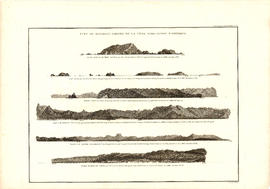
Vue de diverses parties de la côte nord-ouest d'Amérique
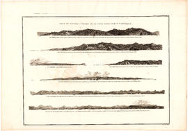
Vue de diverses parties de la côte nord-ouest d'Amérique

Visitors map of Vancouver ; world famous Stanley Park ; downtown Vancouver

Visitors map of Vancouver

Visitors map of Vancouver

Visitors map of Vancouver

Visit the souvenir shop
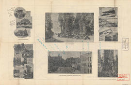
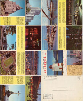
Views of Vancouver

Victoria, vicinity and Vancouver Island

Vest pocket map of Vancouver : map D

Vest pocket map of Vancouver : map cover

Vest pocket map of Vancouver : map C

Vest pocket map of Vancouver : map B

Vest pocket map of Vancouver : map A

Vancouver, New Westminster, Delta and Surrey : postal area

Vancouver, Canada

Vancouver, British Columbia, south-easterly portion, formerly South Vancouver : major street plan

Vancouver, British Columbia, Canada

Vancouver, British Columbia : south-westerly portion, formerly Point Grey : major street plan

Vancouver, British Columbia : northerly portion, former City of Vancouver : major street plan

Vancouver, British Columbia

Vancouver, British Columbia
Vancouver, British Columbia

Vancouver, British Columbia

Vancouver, British Columbia
![Vancouver, B.C., the Pacific coast terminus of the C.P.R. [Canadian Pacific Railway]](/uploads/r/null/8/3/f/83fcf65f0d66d64e6357d0d647e0ea6e2fa4aae4c3d1919f952d7725b4299cda/623e750c-fbab-43b7-a496-d20b384baeb6-LEG1321_142.jpg)
Vancouver, B.C., the Pacific coast terminus of the C.P.R. [Canadian Pacific Railway]
![Vancouver, B.C., the Pacific coast terminus of the C.P.R. [Canadian Pacific Railway]](/uploads/r/null/e/2/c/e2cdc004f3cf462100ed2ef053aa6087887b3f3200917cd5fba6292afb3b2d2d/bfcde3fa-32d7-4d08-86e5-ecf70c6f8388-LEG1340_142.jpg)
Vancouver, B.C., the Pacific coast terminus of the C.P.R. [Canadian Pacific Railway]

Vancouver, B.C., Pacific terminus of the C.P.R.

Vancouver, B.C., Pacific terminus of the C.P.R.

Vancouver, B.C. zoning diagram

Vancouver, B.C. street map

Vancouver, B.C. Plan showing location of water pipes, hydrants, etc. [Westminster Avenue to McLean Drive]
![Vancouver, B.C. Plan showing location of water pipes, hydrants, etc. [West End]](/uploads/r/null/0/5/05354f71931ba85b05864a2adeb3580a6365ddf962e5084f0bb51c68608364a0/3f57f512-bd27-404e-a332-e0881405c2ac-MAP72_142.jpg)
Vancouver, B.C. Plan showing location of water pipes, hydrants, etc. [West End]

Vancouver, B.C. Plan showing location of water pipes, hydrants, etc. [Victoria Drive to First Avenue to Prince Edward Street to 16th Avenue]
![Vancouver, B.C. Plan showing location of water pipes, hydrants, etc. [South Granville]](/uploads/r/null/e/a/eadb6d7351a77ac5788832abd83754cbe2966049728712aa7773bf6f2a74ff34/819e5ce5-621b-43ff-b1f5-f3bf4cac0562-MAP72_142.jpg)
Vancouver, B.C. Plan showing location of water pipes, hydrants, etc. [South Granville]
![Vancouver, B.C. Plan showing location of water pipes, hydrants, etc. [Kitsilano]](/uploads/r/null/0/e/0e33cc4d2f081f551fe6919d35ea37236a6e237a2f5927834d275556995fccfc/0f6ac1ff-8457-41f3-a386-26328c66a4b0-MAP72_142.jpg)
Vancouver, B.C. Plan showing location of water pipes, hydrants, etc. [Kitsilano]
![Vancouver, B.C. Plan showing location of water pipes, hydrants, etc. [Hastings Sunrise]](/uploads/r/null/b/c/bc8cb6a6f5ac5df0dd88a65e8a29ecceca242bde2c1b605533ad17eb835cc450/b2741291-73c5-4a98-9f41-db7fdc46fe83-MAP72_142.jpg)
Vancouver, B.C. Plan showing location of water pipes, hydrants, etc. [Hastings Sunrise]
![Vancouver, B.C. Plan showing location of water pipes, hydrants, etc. [Hastings Park area]](/uploads/r/null/0/c/0c5e2bf211ef2e6dfd7a025d620f00d0e64653f3c8080a7e2b3699fffe60e5a3/22c75a7d-7301-4578-8f71-378ca61a6b27-MAP72_142.jpg)
Vancouver, B.C. Plan showing location of water pipes, hydrants, etc. [Hastings Park area]
![Vancouver, B.C. Plan showing location of water pipes, hydrants, etc. [Grandview]](/uploads/r/null/8/8/88632d271347b57b818fde723ce9ea599c725a5190b4fb2bbb11e5f98e3809ae/3657fbb2-2cf9-4d03-b885-3836ab221252-MAP72_142.jpg)
Vancouver, B.C. Plan showing location of water pipes, hydrants, etc. [Grandview]
![Vancouver, B.C. Plan showing location of water pipes, hydrants, etc. [Fairview slopes]](/uploads/r/null/6/9/69e0d6904facfa2a814069c15122fba46fc4d8077bff76402e95484a4b13d4d8/313b8940-1e98-45d4-b077-abe0f6bee66a-MAP72_142.jpg)
Vancouver, B.C. Plan showing location of water pipes, hydrants, etc. [Fairview slopes]
![Vancouver, B.C. Plan showing location of water pipes, hydrants, etc. [Burrard Street to Gore Avenue]](/uploads/r/null/7/7/7797d041e72dece35da90eab6733a9db50a0b2115ad816578d3633a58bf31761/ebc0f54a-c23a-425c-816d-1dd268a2e4e7-MAP72_142.jpg)
Vancouver, B.C. Plan showing location of water pipes, hydrants, etc. [Burrard Street to Gore Avenue]

Vancouver, B.C. city map : street index to Vancouver map, detail map of Downtown Vancouver, and tourist attractions

Vancouver, B.C. 1890 : built-on area
![[Vancouver, B.C. : district lots]](/uploads/r/null/4/a/4a5c15633319c3754d3aa0cc525470bfebcf5a98ad8caeedf44b777194f300bd/2f055d65-47f7-4679-bb91-66b8f1843d2f-MAP531_142.jpg)
[Vancouver, B.C. : district lots]