
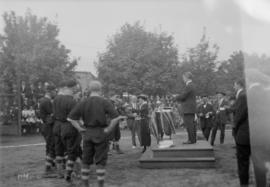
Baseball City League presenting trophies
- AM1535-: CVA 99-886
- Item
- 20 Aug. 1920
Part of Stuart Thomson fonds
Item is a photograph showing Ab Mortimer of the International Longshoremen's Association (I.L.A.) team receiving a medal for lead hitter.
1519 results with digital objects Show results with digital objects
Baseball City League presenting trophies
Part of Stuart Thomson fonds
Item is a photograph showing Ab Mortimer of the International Longshoremen's Association (I.L.A.) team receiving a medal for lead hitter.

Baseball City League presenting trophies
Part of Stuart Thomson fonds
Item is a photograph showing either Joe Brown or Stacey Hann of the International Longshoreman's Association (I.L.A.) team receiving a medal. Teammate Ab Mortimer is also visible just behind.
![I.L.A. [International Longshoreman's Association] Baseball Team - City League Champions - 1920](/uploads/r/null/e/7/e754cdd9294aa90fb1f723eb8c894dcaefd63a16a5ff63e06d3cf8231c97179c/98759aac-4ddf-48bd-8795-c0077e0bbc6e-A16747_142.jpg)
I.L.A. [International Longshoreman's Association] Baseball Team - City League Champions - 1920
Part of Stuart Thomson fonds
Item is a photograph showing a group portrait of the amateur city league team, the Dockers, posing with their trophies at Powell Street Grounds. Eddie Nahanee is standing far left and Ab Mortimer is seated in the front row, second from the right.
Baseball City League presenting trophies
Part of Stuart Thomson fonds
Item is a photograph showing the International Longshoreman's Association (I.L.A.) team receiving a trophy cup at the Powell Street Grounds.

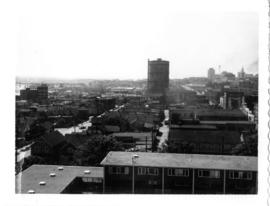
Looking south-east from roof of #1 warehouse over the city

A Chinese parade with women on white horses
Part of Karl Haspel fonds

A Chinese parade on East Pender Street
Part of Karl Haspel fonds
Sign for "Kwong Yee Lung Co." is visible.

A Chinese parade showing acrobats
Part of Karl Haspel fonds
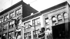
A Chinese parade showing acrobats
Part of Karl Haspel fonds

A Chinese parade, showing float for the Chinese Benevolent Association
Part of Karl Haspel fonds

A Chinese parade showing acrobats
Part of Karl Haspel fonds
![[Aerial view of Vancouver] sawmill and West Coast Hardwood Ltd, 7th Avenue and Clark Drive](/uploads/r/null/9/0/b/90bb9ab825876d633ac9282b128e51a609b2d9249375b17ac9a5a9466f055f24/44a65d73-fb54-4de9-beaa-497a8bbf79ab-CVA145-15_142.jpg)
[Aerial view of Vancouver] sawmill and West Coast Hardwood Ltd, 7th Avenue and Clark Drive
Part of City of Vancouver fonds
Item is a photograph looking north, showing the velodrome and Clark Drive between Broadway and First Avenue.
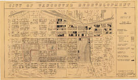
Part of City of Vancouver fonds
Item shows building types and proposed layout of buildings and streets in Strathcona as part of the 1957 Vancouver Redevelopment Study.
Part of City of Vancouver fonds
Item is a Planning Department map showing ownership of property included in the acquisition program. Base map is bounded by Main Street, Glen Drive, Alexander Street, and Atlantic Street, and shows streets, legal descriptions, schools, parks and Canadian Pacific and Canadian National railway lines.
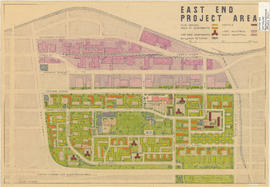
Projects no. 1 and 2 maps and plans
Part of City of Vancouver fonds
File consists primarily of maps pertaining to redevelopment project 1, areas A and D, but also contains two maps from project 2. Maps include identification plans of property to be acquired; boundaries of clearance areas; general and detailed redevelopment plans; and maps showing the layout of existing and proposed utilities.

View of 600 block East Georgia Street
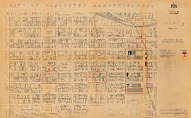
City of Vancouver redevelopment : project 1, area A-1 : City-owned land and buildings to be retained
Part of City of Vancouver fonds
Item is a map showing city-owned land, buildings in clearance areas to be retained, and boundaries of clearance areas. Base map shows streets, outlines of buildings, and topographic contour lines for the area from Main Street to Glen Drive and Alexander Street to Atlantic Street.

City of Vancouver redevelopment : project 1, area A-1.1 : existing and proposed utilities
Part of City of Vancouver fonds
Item is a map showing existing and proposed utilities for the area bounded by Campbell Avenue, Glen Drive, Cordova Street, and Union Street, and has been annotated to show which utilities are cost shareable under the Section 23 program.
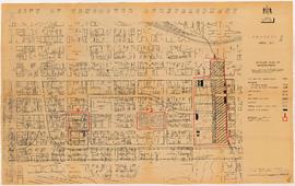
City of Vancouver redevelopment : project 1, area A-1 : detailed plan of redevelopment
Part of City of Vancouver fonds
Item is a map showing housing types, new streets and lanes, easements, and buildings to be retained as part of Project 1, and the boundaries of areas A1.1, A1.2, and A1.3. Base map shows streets, outlines of buildings, and topographic contour lines for the area from Main Street to Glen Drive and Alexander Street to Atlantic Street.

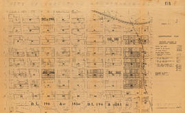
Part of City of Vancouver fonds
Item is a map showing boundaries of clearance areas in Strathcona and ownership of property included in the acquisition program. Base map is bounded by Main Street, Glen Drive, Alexander Street, and Atlantic Street, and shows streets, legal descriptions, schools, parks and Canadian Pacific and Canadian National railway lines.
City of Vancouver redevelopment : project 1 : plan showing redevelopment of area A-1.1 as proposed
Part of City of Vancouver fonds
Item is a map showing building types, streets and lanes, easements, condition of buildings, property ownership, and revised clearance area boundaries in the area bounded by Campbell Avenue, Raymur Avenue, Powell Street, and Union Street.

South west, south, and south east views from Hastings Viaduct
Part of City of Vancouver fonds
Item is a panoramic photograph showing south west, south, and south east views from the Hastings viaduct. On the left there is an arrow pointing to United Milling (feed and grain). Annotation on the back identifies the Manke Cabins on the right.

Part of City of Vancouver fonds
Item is a map showing boundaries of clearance areas in Strathcona and ownership of property included in the acquisition program. Further annotations show the status of property acquisition and demolition. Base map is bounded by Main Street, Glen Drive, Alexander Street, and Atlantic Street, and shows streets, legal descriptions, schools, parks and Canadian Pacific and Canadian National railway lines.
The story of Strathcona School, 1873-1961

City of Vancouver redevelopment : project 1, area A-1 : detailed plan of redevelopment
Part of City of Vancouver fonds
Item is a map showing housing types, new streets and lanes, easements, and buildings to be retained as part of Project 1, and the boundaries of areas A1.1, A1.2, and A1.3. Base map shows streets, outlines of buildings, and topographic contour lines for the area from Main Street to Glen Drive and Alexander Street to Atlantic Street.
Part of City of Vancouver fonds
Item is a map showing boundaries of clearance areas in Strathcona and ownership of property included in the acquisition program. Base map is bounded by Main Street, Glen Drive, Alexander Street, and Atlantic Street, and shows streets, legal descriptions, schools, parks and Canadian Pacific and Canadian National railway lines.

Part of City of Vancouver fonds
Item is a panoramic photograph showing the view across McLean Park to houses on the 400 block of East Georgia.
Part of City of Vancouver fonds
Item is a photograph showing the old B.C. Electric Gas Plant from roof of McLean Park High-rise, looking east. Annotation on back: "Old Georgia Viaduct to right of the gas plant."
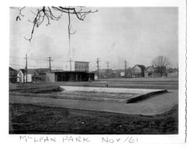
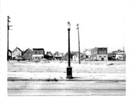
400 Block East Georgia across McLean Park
Part of City of Vancouver fonds
Item is a panoramic photograph showing the view across McLean Park to houses on the 400 block of East Georgia.
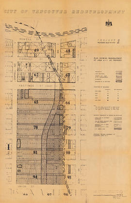
City of Vancouver redevelopment : project 2, area A-2 : plan of redevelopment
Part of City of Vancouver fonds
Item is a map showing boundaries of clearance areas, proposed land use and street system, new streets and lanes, easements, sites not to be acquired, and buildings to be retained in project 2. Some clearance boundaries are hand-coloured. Map covers the area bounded by Main Street, Clark Drive, Alexander Street, and Atlantic Street.
Old B.C. Electric Gas Plant from roof of McLean Park High-rise, looking east
Part of City of Vancouver fonds

New McLean park in foreground, 700 block Keefer in background
Part of City of Vancouver fonds

McLean Park with 700 Block Keefer in background
Part of City of Vancouver fonds
![Italian grandmother and her two little ones at McLean Replacement [Campbell Avenue at Union Street]](/uploads/r/null/9/6/960a78058291afef9d722585d51f784a0aab0c39436ea8cd751c9a544903f0a7/e55e257f-0156-408c-ae65-f3ab2805cff3-A44619_142.jpg)
Italian grandmother and her two little ones at McLean Replacement [Campbell Avenue at Union Street]
Part of City of Vancouver fonds
File consists of identification plans and redevelopment plans for project 2.
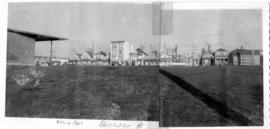
Looking north across new McLean Park at 700 block Keefer
Part of City of Vancouver fonds

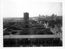
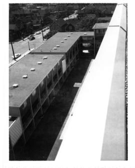
Intersection of Georgia and Dunlevy, looking north-west from roof of high-rise
Part of City of Vancouver fonds
View of Strathcona, McLean Park housing development in foreground
Part of City of Vancouver fonds
New McLean park in foreground, 700 block Keefer in background
Part of City of Vancouver fonds
Looking south-west from roof of McLean Park High-rise, intersection of Union and Dunlevy
Part of City of Vancouver fonds

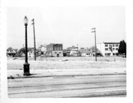
700 Block East Georgia, looking west
Part of City of Vancouver fonds
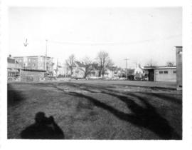
Start of construction on McLean Park from south-west corner of park
Part of City of Vancouver fonds
Item is a photograph showing the start of construction on McLean Park from south-west corner of park. Hand drawn arrow is identified by an annotation on the back as the Jackson Apartments on the north-east corner of Jackson and Georgia.
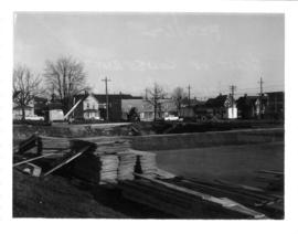
Start of construction on McLean Park from north-west corner of park
Part of City of Vancouver fonds

Project 2, area a-2 : condition of buildings
Part of City of Vancouver fonds
Item is a map showing condition of buildings (ranging from very good to very poor) and sites without buildings in use for storage or parking in the area from Railway Street in the north to Atlantic Street in the south and from Clark Drive in the east to Main Street in the west.

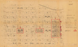
Project 2, area a-2 : proposed property acquisitions project 2
Part of City of Vancouver fonds
Item is a map showing boundaries of project in area a, property to be acquired, proposed street widening and city owned property included. Annotations show boundaries of project areas, property too be acquired, proposed street widening and properties already owned by the City. Map has been noted as Preliminary.

Project 2: identification plan
Part of City of Vancouver fonds
Item is a map showing city owned property, adjacent lots in same ownership, non-adjacent lots in same ownership, property to be acquired, streets and lanes to be acquired, the boundaries of project 2 clearance, the boundaries of project 1 clearance and the realignment of Raymur Avenue in the area from Railway Street in the north to Atlantic Street in the south and from Clark Drive in the east to Main Steet in the west.

Project 2, part of area "a" : aerial photograph
Part of City of Vancouver fonds
Item is a map in the form of an aerial photograph, which depicting the part of the city covered by the project: from Railway Street in the north to Prior Street in the south and from Clark Drive in the east to Main Street in the west.
Attached label indicates that the map was approved by Council Sept. 17, 1963.

Project 2, part of area "a" : aerial photograph
Part of City of Vancouver fonds
Item is a map showing the boundaries of clearance areas for project 1 (sub areas 1, 2 & 3) and project 2 (sub areas 5, 6 & 7). These areas have been outlined in yellow.

Project 2, part of area "a" : identification plan
Part of City of Vancouver fonds
Item is a map showing property status for properties in project areas 1 and 2. The map shows city owned property, adjacent lots in same ownership, non-adjacent lots in same ownership, and property to be acquired.

Project 2, part of area "a" : condition of buildings
Part of City of Vancouver fonds
Item is a map showing the condition of buildings (ranging from very good to very poor) within the boundaries of project 2, area "a". The map also shows the boundaries of project 2 clearance, the boundaries of project 1 clearance and the realignment of Raymur Avenue.