Item part is a photograph of sidewalk and storefronts on Robson Street with an unidentified clothing shop's front window display visible in the foreground and the Freybe Delicatessen (1085 Robson Street) signage further up the street. The Sheraton Landmark hotel is visible in the background.
Item is a postcard printed with an image of the Vancouver Kitsilano Boys' Band posed on the steps of the Vancouver courthouse with their instruments and their conductor, Arthur W. Delamont
Item is a postcard printed with an image of the Vancouver Kitsilano Boys' Band posed on the steps of the Vancouver courthouse with their instruments and their conductor, Arthur W. Delamont. This postcard includes personal correspondence. Sent to Mrs. Mary Robinson, Queens Park, London, from Susan.
Map is a plan of downtown Vancouver with areas shaded to indicate streets, squares, malls and arcades, in which the movement of vehicles is not permitted at all or is restricted. Although the entire downtown area is shown, shading pertains only to Jervis Street and Main Street and Burrard Inlet and Nelson Street. Note written in the bottom right corner of the map reads "B 1960 Jan., Traffic Plans, small folder."
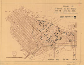
Map is a plan of downtown Vancouver showing parking structures and parking lots in the area between Jervis Street and Main Street and Burrard Inlet and Nelson Street. The source of the map is indicated as 'parking supply and demand projections, September 1959'. Note written in the bottom right corner of the map reads "B 1960 Jan., Traffic Plans, small folder."
Map is a plan of downtown Vancouver showing parking structures and parking lots in the area between Jervis Street and Main Street and Burrard Inlet and Nelson Street. The source of the map is indicated as an aerial photograph taken April 1959. Note written in the bottom right corner of the map reads "B 1960 Jan., Traffic Plans, small folder."
Map is a plan of downtown Vancouver showing parking structures and parking lots in the area between Jervis Street and Main Street and Burrard Inlet and Nelson Street. The source of the map is indicated as 'The Downtown Parking Report'. Note written in the bottom right corner of the map reads "B 1960 Jan., Traffic Plans, small folder."
Item consists of raw footage featuring B.C./Expo 86 aerials; shot in 35mm and transferred to one inch tape. Original negative no longer exists and only video footage survives. Some of this material was used in Yaletown Production's video postcard series.
Item part is a photograph of evangelists and a violin playing busker under the awning of the Hudson's Bay Company building (674 Granville Street) near the intersection of Granville Street and W. Georgia Street.
Item part is a photograph of evangelists and a violin playing busker under the awning of the Hudson's Bay Company building (674 Granville Street) near the intersection of Granville Street and W. Georgia Street.
Item part is a photograph of an evangelist on the sidewalk of W. Georgia Street between Granville Street and Seymour Street. The awning of the Hudson's Bay Company building (674 Granville Street) is visible above the sidewalk and The Strand theatre (600 W. Georgia Street) is visible across the street.
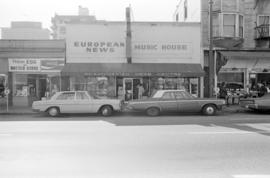
Item part is a photograph of storefronts on Robson Street focusing on the European News & Import House store (1044 Robson Street) and including a Fresh Egg and Butter Store to the left, and Standard Produce Co. (1052 Robson Street) to the right. "Scandinavian News Centre" is written on the awning.
Item part is a photograph of the sidewalk, awnings, entrance, and front window displays of the European News & Import House store (1044 Robson Street) with cars parked in front, taken from across Robson Street. "Scandinavian News Centre" is written on the awning.
Item part is a photograph of the entrance to the collection of shops at The Garage (12 Water Street). On the left is Graphic House printers, on the right is Chocolate Factory candy, and in the centre background is the Serenite Restaurant.
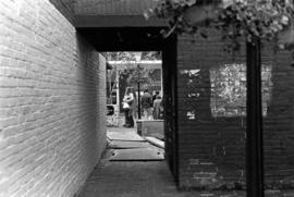
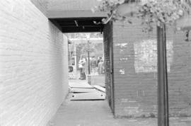
Item is a photograph of a view through an alley entrance to Gaolers Mews, just south of Guenter's Delicatessen (203 Carrall Street), Maple Tree Square, Gastown.
Item part is a photograph of a view through an alley entrance to Gaolers Mews, just south of Guenter's Delicatessen (203 Carrall Street), Maple Tree Square, Gastown.
Item part is a photograph of pedestrians on en enclosed Granville Street a sidewalk near the intersection of Granville Street and W. Georgia Street. The sidewalk is enclosed with a temporary construction enclosure on the Granville Street side and the under the awning and northwest side of the Hudson's Bay Company building (674 Granville Street).
Item part is a photograph of Pacific Centre plaza at the intersection of W. Georgia Street and Granville Street, looking west from the corner of the Hudson's Bay Company building (674 Granville Street) diagonally across the intersection. The Eaton's Building (701 Granville Street) is visible on the left of the plaza and the Toronto Dominion Bank tower (700 W. Georgia Street) is on the right.
Item part is a photograph of a street and sidewalk scene taken from the sidewalk outside the Eaton's Building (701 Granville Street) looking northeast up Granville Street. The visible storefronts include Scott's Cafe (722 Granville Street), Roselawn Florist (724 Granville Street), and Vancouver Block (736 Granville Street).
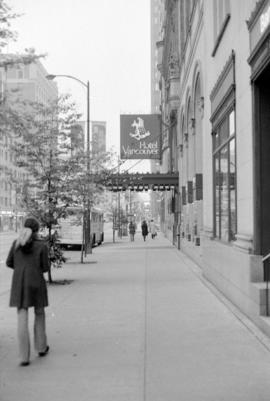
Item part is a photograph of the sidewalk along the southwestern, Robson Street, edge of the Eaton's Building (701 Granville Street) with the Sheraton Landmark hotel visible in the background.
Item part is a photograph of a dump truck working on a street with a construction worker close by. [Somewhere on Robson Street between Granville Street and Hornby Street]
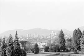
Item part is a photograph of the top of the downtown Vancouver skyline over the trees of a Fairview neighborhood. This photograph was taken from one of the lower floors of the Plaza 500 Hotel & Convention Centre.
Item part is a photograph of the top of the downtown Vancouver skyline over the trees of a Fairview neighborhood. This photograph was taken from one of the lower floors of the Plaza 500 Hotel & Convention Centre.
Item part is a photograph of the top of the downtown Vancouver skyline over the trees of a Fairview neighborhood. This photograph was taken from one of the lower floors of the Plaza 500 Hotel & Convention Centre.
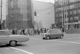
Item is a set of negatives of street photography scenes in downtown Vancouver. The scenes captured are from W. Georgia Street between Seymour Street and Howe Street, Robson Street between Bute Street and Granville Street, and a small part of Granville Street near Robson Street. The photograph subjects are street scenes, predominantly pedestrians on the sidewalk with area businesses in the background. This set contains the raw photographs from the roll the photographer shot in their original order. The associated contact sheet has selection marks for frame 34.
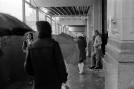
Item is a set of negatives of street photography scenes in downtown Vancouver. The scenes were captured in the areas around the Birks Building (700 Granville Street) and the Hudson's Bay Company building (674 Granville St) and immediate surroundings on Seymour Street, W. Georgia Street, and Granville Street. The photograph subjects are rainy day street scenes, predominantly pedestrians on the sidewalk with area businesses in the background. This set contains the raw photographs from the roll the photographer shot in their original order. The associated contact sheet has selection marks for frames 3, 4, and 11.
Item is a set of negatives of street photography scenes in downtown Vancouver. The scenes captured are along Robson Street between Bute Street and Granville Street, from Granville Street to W. Georgia Street, and from W. Georgia Street to Seymour Street. The photograph subjects are street scenes, predominantly pedestrians on the sidewalk with area businesses in the background. This set contains the raw photographs from the roll the photographer shot in their original order. The associated contact sheet has selection marks for frames 13 and 16.
Item is a set of negatives of street photography scenes in downtown Vancouver. The scenes were captured roughly along a route beginning at Granville Street and W. Georgia Street, proceeding southwest on Granville Street, northwest onto Robson Street, northeast onto Burrard Street, and finally southeast onto W. Georgia Street to the intersection of W. Georgia Street and Seymour Street. The photograph subjects are everyday street scenes, predominantly storefronts of local businesses, department stores, pedestrians on the sidewalk, and buses. This set contains the raw photographs from the roll the photographer shot in their original order. The associated contact sheet has selection marks for frames 7, 21, and 31.
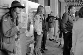
Item is a set of negatives of street photography scenes in downtown Vancouver. The scenes captured are predominantly from the area immediately surrounding the Granville Street and W. Georgia Street intersection. The photograph subjects are street scenes, predominantly people queuing for buses or people at crosswalks, waiting and crossing. This set contains the raw photographs from the roll the photographer shot in their original order. The associated contact sheet has selection marks for frames 7 and 18.
Item is a set of negatives of street photography scenes in downtown Vancouver. The scenes captured are along Granville Street from W. Georgia Street to Robson Street and then northwest on Robson Street until just after Thurlow Street. The photograph subjects are rainy street scenes, either early evening or very overcast, predominantly pedestrians on the sidewalk with area businesses in the background. This set contains the raw photographs from the roll the photographer shot in their original order. The associated contact sheet has selection marks for frames 3A, 8A, 11A, 16A, 21A, and 23A.
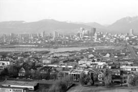
Item part is a photograph of downtown Vancouver, including a view down Cambie Street across the Cambie Street Bridge, and adjacent neighborhoods in Fairview and Mount Pleasant.
Item part is a photograph of downtown Vancouver, including a view down Cambie Street across the Cambie Street Bridge, and adjacent neighborhoods in Fairview and Mount Pleasant.
Item part is a photograph of downtown Vancouver, including a view down Cambie Street across the Cambie Street Bridge, and adjacent neighborhoods in Fairview and Mount Pleasant.
Item part is a photograph of downtown Vancouver, including a view down Cambie Street across the Cambie Street Bridge, and adjacent neighborhoods in Fairview and Mount Pleasant.
Item part is a photograph of downtown Vancouver, including a view down Cambie Street across the Cambie Street Bridge, and adjacent neighborhoods in Fairview and Mount Pleasant. The Granville Street Bridge and the Burrard Street Bridge are visible at the far left.
Item part is a photograph of downtown Vancouver, including a view down Cambie Street across the Cambie Street Bridge, and adjacent neighborhoods in Fairview and Mount Pleasant.

![Flagpole Courthouse [taken from Hotel Vancouver]](/uploads/r/null/7/c/7ce2a1eb66138815b14b5df8b563a4271e3c12ac411667a5dd73bbbac8136bbf/4c60e558-dfbe-4d0f-8bfc-22e732a810bf-A02980_142.jpg)
![First prize winners [Vancouver Kitsilano Boys' Band]](/uploads/r/null/1/9/e/19eb2dc6b9012ce3e6d8bfad697a6f9e88ac827377fdf155f90eadec95df57c0/7be3d32f-dfcc-4eab-aa76-3ea969da71b2-AM1052P-423_142.jpg)
![First prize winners [Vancouver Kitsilano Boys' Band]](/uploads/r/null/3/0/e/30e2e1a9af29b7ce7e27b1edfa64abfa205e1f9399f453a646360f95cb963935/13e3a073-10b1-4b70-b461-eb4767532792-AM1052P-422_142.jpg)


![[Exterior view of the] Rogers Building at 470 Granville [Street]](/uploads/r/null/4/6/46adbf6de86563ba2801897f647aeec25ac060dc7aaec2f768c50b1ef535ff0c/96b3499c-9b58-48ef-bd7b-1103447affaa-A58791_142.jpg)


![Eaton's [73 Water Street]](/uploads/r/null/e/f/efffbe7541e9c786725d223540782783ca09254430a2f2857e65bb3cd39091f3/7b145e73-e3e4-47ae-959b-bfc17c3181a9-CVA810-263_142.jpg)
![[Eastern view from the top of the old Hotel Vancouver]](/uploads/r/null/d/a/da0a489c3b8957a64fdf74da51289d290e555363d92edae9ae8fb99703784361/093f0de7-0b8e-4e58-be5c-bf31c5fec868-A21940_142.jpg)


![[Downtown Vancouver and Burrard Inlet, viewed from the Hotel Vancouver]](/uploads/r/null/2/c/2c6b2767f8dd9c1bd977f99a67e732f9bf5576f37c2e41778903e807557133bc/bd0b1ad5-6134-4972-b994-3fada39c3350-A04063_142.jpg)