Series consists of building case files concerning permits to demolish heritage designated buildings typically containing heritage evaluation forms including photographs, as well as various reports, correspondence, news clippings, etc. Arranged al...
Series contains a large accrual of photographs produced by and for the Planning Dept. which require further appraisal, series analysis, and description. Arranged chronologically.
Series consists of maps, plans, drawings, charts and photographs created, amended or used by the Planning Department in the course of drafting ideas, compiling information, preparing displays, or designing publication copy relating to planning act...
Series consists of material which made up the reference library created for and used by Planning Department staff in the course of their business. Records are primarily reports created by or on behalf of the Planning Department in relation to the ...
Series documents the core planning functions performed by the Planning Department, including land use and development planning, administering the Zoning and Development By-law and related by-laws, and providing advice on planning matters to other ...
Series consists of case files on land and lots considered for subdivision approval. Each case file is represented by one microfiche. Arranged in legal description order with the following area or project files at the beginning: B.C. Place, Cana...
Series consists of records documenting the City's planning functions as they applied to City-owned property. The records document activities such as: disposing of City-owned property by sale or exchange, subdivision of lots and blocks, and th...
Series consists of records documenting proposed and initiated amendments to the main text, appendices and schedules of Vancouver's Zoning and Development By-law (No. 3575) and its predecessor Zoning By-law (no. 2516 ). The series does not con...
Series consists mainly of 25 x 25 cm b&w photographs, each showing a perpendicular view of a small area of Vancouver (sometimes known as mosaics). Series also includes 11 photographs of the Cassiar Connector taken in 1991, 62 x 66 cm or smaller.
Series consists of LMRPB files kept by Planning Department directors G. Sutton Brown, G.F. Fountain, and W.E. Graham (and their deputies) relating to their service as consultants to the Board. Records include correspondence, minutes, financial st...
Item is a map that would have been created to accompany an application for re-zoning for Block 235 D.L. 538 and water lots 5834, 5601 and 5600. It appears that this application failed, as no amendment to By-law 3575 for these properties has been f...
Item is a copy of an Engineering Department map which has been annotated to show pre-1916 residential construction, existing major streets, public and semi-public buildings, single and two-family dwellings, multiple family dwellings, district comm...
Series consists of photographs taken by the Planning Department according to the requirements of departmental projects over the years. Twenty-one of Vancouver's local areas are represented, including: Central Business District [downtown], F...
Item is a map showing the locations of retail shopping centres in Vancouver according to local, district and regional function. Map also shows locations of service stations and commercially zoned areas.
Series consists of records documenting the development and implementation of programs to identify and protect structures possessing heritage value or features.The series consists of subject and correspondence files containing information on a wide...
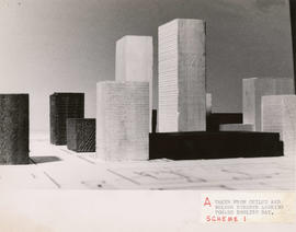
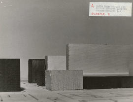
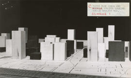
Item consists of a photograph depicting a model created by Planning Department staff to study view obstructions which result from various building configurations, based on different options to be included in zoning regulations for the West End.
Series consists of cronaflex stereoscapic aerial survey photographs used for data collection to support planning and engineering activities. The photographs were created by a variety of photographic firms, under contract for the Planning Departmen...
Item is a copy of a Planning Department map of downtown Vancouver. This copy has a mylar overlay which masks the area north of Georgia Street between Bidwell and Chilco Streets.
Series consists of films or copies of films collected by the Planning Department, and related to the City and regional planning of the 1960s: urban renewal, downtown planning, and harbour development. Arranged chronologically. The films were pre...
Item is a map in the form of an aerial survey photograph which shows the west side of Vancouver bounded in the north and south by 14th Ave. and S.W. Marine Drive, and in the east and west by Blenheim St. and Sasamat St.
Series consists of records documenting research conducted by Heritage Planners and private heritage contractors working on behalf of the Planning Department into the heritage features of various structures in the City of Vancouver. The structures ...
Series consists of computer printouts of primarily business license, development permit and building permit data, relating to the preparation of analyses of building characteristics and business, development, and land use activities. Printouts us...
Series consists of photographs of building facades of the "character areas" of Vancouver taken for reference purposes to aid heritage and development planning processes. (A few months earlier the department had prepared its Goals and Ob...
Series consists of photographs created by the Planning Department to document the renovation and construction of Blood Alley Square, Trounce Alley, and Maple Tree Square.
Series consists of images which systematically and comprehensively document the whole of Vancouver's central commercial area, along the waterfront from Cardero to Carrall, narrowing southward to False Creek (Thurlow to Richards at the souther...
Series consists of heritage evaluation forms on buildings deleted from the heritage register because the building has been demolished. The request for a deletion originates from the applicant for a development permit where that redevelopment enta...
Series consists of a photocopied set of heritage evaluation forms completed for older buildings as background information in the preparation of the revised 1986 heritage inventory. Work carried out by consultants Commonwealth Historic Resource Ma...
Series consists of three sets of photographic surveys which were carried out to assist the heritage designation and evaluation process resulting in the revised 1986 heritage inventory. The three sets are arranged in the following subseries: - S...
Series consists of records of the South Shaughnessy Single Family Zoning Review Program, and document design and landscaping of houses in Shaugnessy.The series consists of two subseries: Consultant's data forms with photographs (1990) and Pl...
Series consists of records documenting the nomination of projects for City of Vancouver Heritage Awards by property owners, developers, interested individuals and community groups.The series consists of records supporting nominations, including: n...
File consists of one dataset showing boundaries of Vancouver's 22 local areas, also known as local planning areas. Dataset is as it appeared on November 1, 2010.
Vancouver (B.C.). Information Technology Department