Showing 94 results
Archival description
City of Vancouver, British Columbia

City of Vancouver, British Columbia

Redevelopment plan for Jericho Department of National Defence lands

Map showing location of single women receiving assistance by mail

Map showing location of single men receiving assistance by mail

Sheet 41 : Ontario Street to Inverness Street and Twenty-eighth Avenue to Sixteenth Avenue

Sheet 49 : Arbutus Street to Oak Street and Thirty-third Avenue to Laurier Avenue

Sheet 57 : Nanaimo Street to Doman Street and Joyce Street and Forty-ninth Avenue to Forty-first Avenue

Sheet 59 : Quebec Street to Inverness Street and Forty-seventh Avenue to Thirty-seventh Avenue
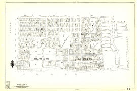
Sheet 77 : Kerr Street to Greenall Avenue and Southeast Marine Drive to Asquith Avenue

Sheet 79 : Gladstone Street to Kerr Street and North Arm of Fraser River to Bobolink Avenue

Sheet 37 : Rupert Street to Carleton Avenue and Wellington Avenue to Twenty-second Avenue and Elmwood Street

Sheet 39 : Kingsway and Nanaimo Street to Rupert Street and Ward Street to Twenty-second Avenue
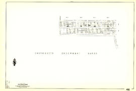
Sheet 46 : Blanca Street to Discovery Street and Sixteenth Avenue to Fourteenth Avenue
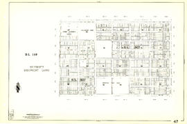
Sheet 47 : Camosun Street to Blenheim Street and Thirty-third Avenue to King Edward Avenue

Sheet 50 : Oak Street to Ontario Street and Thirty-seventh Avenue to Twenty-eighth Avenue

Sheet 51 : Ontario Street to Inverness Street and Thirty-seventh Avenue to Twenty-eighth Avenue

Sheet 53 : Inverness Street to Nanaimo Street and Forty-first Avenue to Thirty-second Avenue

Sheet 54 : Nanaimo Street to Joyce Street, Cecil Street and McHardy Street and Forty-first Avenue to Ward Street and Vanness Avenue

Sheet 55 : Cecil Street and McHardy Street to Patterson Avenue and Kingsway to Monmouth Avenue and Price Street
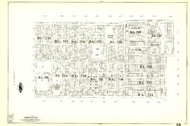
Sheet 58 : Inverness Street to Nanaimo Street and Forty-ninth Avenue to Forty-first Avenue

Sheet 67 : Musqueam Indian Reserve to Musqueam Park and North Arm, Fraser River to Southwest Marine Drive

Sheet 73 : Quebec Street to Inverness Street and Fifty-seventh Avenue to Forty-seventh Avenue

Sheet 76 : Kerr Street to Mondy Avenue and Asquith Avenue to Forty-ninth Avenue

Sheet 78 : Kerr Street to Ivy Avenue and North Arm of Fraser River to Southeast Marine Drive

Sheet 84 : Laurel Street to Main Street and North Arm of Fraser River to Southwest Marine Drive

Sheet 86 : Angus Drive to Laurel Street and Seventy-fifth Avenue to Sixty-seventh Avenue

Sheet 40 : Inverness Street to Nanaimo Street and Twenty-second Avenue to Thirteenth Avenue

Sheet 48 : Blenheim Street to Arbutus Street and Thirty-third Avenue to Twenty-third Avenue

Sheet 56 : Doman Street and Joyce Street to Boundary Road and Forty-ninth Avenue to Kingsway
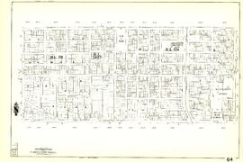
Sheet 64 : Balaclava Street to Cypress Street and Forty-ninth Avenue to Forty-first Avenue

Sheet 70 : Macdonald Street to Cypress Street and Fifty-seventh Avenue to Forty-ninth Avenue

Sheet 72 : Oak Street to Quebec Street and Fifty-eighth Avenue to Forty-sixth Avenue

Sheet 82 : Main Street to Tipping Road and Crompton Street and Twigg Island to Southeast Marine Drive

Sheet 83 : Fremlin Street to Main Street and Southwest Marine Drive to Fifty-seventh Avenue

Sheet 85 : Laburnum Street to Fremlin Street and Sixty-eighth Avenue to Fifty-seventh Avenue

Sheet 88 : Macdonald Street to Angus Drive and Edgington Avenue to Fifty-seventh Avenue

Sheet 63 : Carnarvon Street to Cypress Street and Forty-first Avenue to Thirty-third Avenue

Sheet 43 : East Boulevard to Oak Street and Laurier Avenue to Fourteenth Avenue

Sheet 52 : Inverness Street to Nanaimo Street and Thirty-second Avenue to Twenty-second Avenue

Sheet 66 : Musqueam Indian Reserve to Balaclava Street and Forty-ninth Avenue to Forty-first Avenue

Sheet 71 : Cypress Street to Oak Street and Fifty-seventh Avenue to Forty-ninth Avenue

Sheet 74 : Inverness Street to Nanaimo Street and Sixty-first Avenue to Forty-ninth Avenue

Sheet 75 : Nanaimo Street to Kerr Street and Bobolink Avenue to Forty-ninth Avenue
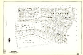
Sheet 80 : Tipping Road, Crompton Street and Inverness Street to Gladstone Street and Mitchell Road to Sixty-first Avenue

Sheet 81 : Main Street to Inverness Street and Southeast Marine Drive to Fifty-seventh Avenue

Index to 400 ft. scale section maps, City of Vancouver, British Columbia
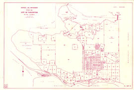
District lot boundaries with the City of Vancouver, British Columbia

Sheet 10 : Clark Drive to Nanaimo Street and Frances Street to Burrard Inlet

Sheet 12 : Nanaimo Street to Cassiar Street and Pender Street to McGill Street
Results 1 to 50 of 94