
Plan & profile of south side of First Ave., between Renfrew St. & Nootka St.
- COV-S365---: LEG1967.04
- Item
- Mar. 30, 1960
Part of City of Vancouver fonds
Vancouver (B.C.). Engineering Services
Plan & profile of south side of First Ave., between Renfrew St. & Nootka St.
Part of City of Vancouver fonds
Vancouver (B.C.). Engineering Services

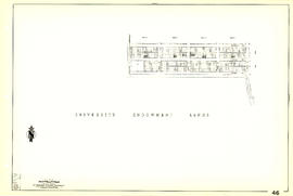
Plan of block occupied by University of British Columbia, Vancouver B.C.
Part of Major Matthews collection
Item is a site plan of the old University of British Columbia site bounded by Laurel Street, Tenth Avenue, Willow Street and 12th Avenue.
Vancouver (B.C.). Engineering Services
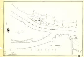
Sheet 90 : Carrington Street to Macdonald Street and Richmond to Celtic Avenue
Part of City of Vancouver Archives technical and cartographic drawing collection
Item is a section showing streets and blocks in the area from Carrington Street to Macdonald Street and Richmond to Celtic Avenue.
Vancouver (B.C.). Engineering Services

Sheet 89 : North Arm of Fraser River to Southwest Marine Drive and Barnard Street
Part of City of Vancouver Archives technical and cartographic drawing collection
Item is a section showing the area from North Arm of Fraser River to Southwest Marine Drive and Barnard Street. Includes streets, blocks, lots and legal descriptions.
Vancouver (B.C.). Engineering Services

Sheet 88 : Macdonald Street to Angus Drive and Edgington Avenue to Fifty-seventh Avenue
Part of City of Vancouver Archives technical and cartographic drawing collection
Item is a section showing the area from Macdonald Street to Angus Drive and Edgington Avenue to Fifty-seventh Avenue. Includes streets, blocks, lots and legal descriptions, and the locations of schools, parks and golf courses.
Vancouver (B.C.). Engineering Services

Sheet 87 : Barnard Street to Heather Street and Beckwith Road to Seventy-fifth Avenue
Part of City of Vancouver Archives technical and cartographic drawing collection
Item is a section showing the area from Barnard Street to Heather Street and the North Arm of the Fraser River to Seventy-fifth Avenue. Includes streets, blocks, lots and legal descriptions, and the locations of schools and parks. Also Includes streets and blocks in Richmond from Beckwith Road to River Drive.
Vancouver (B.C.). Engineering Services

Sheet 86 : Angus Drive to Laurel Street and Seventy-fifth Avenue to Sixty-seventh Avenue
Part of City of Vancouver Archives technical and cartographic drawing collection
Item is a section showing the area from Angus Drive to Laurel Street and Seventy-fifth Avenue to Sixty-seventh Avenue. Includes streets, blocks, lots and legal descriptions, and the locations of schools and parks.
Vancouver (B.C.). Engineering Services

Sheet 85 : Laburnum Street to Fremlin Street and Sixty-eighth Avenue to Fifty-seventh Avenue
Part of City of Vancouver Archives technical and cartographic drawing collection
Item is a section showing the area from Laburnum Street to Fremlin Street and Sixty-eighth Avenue to Fifty-seventh Avenue. Includes streets, blocks, lots and legal descriptions, and the locations of schools and parks.
Vancouver (B.C.). Engineering Services

Sheet 84 : Laurel Street to Main Street and North Arm of Fraser River to Southwest Marine Drive
Part of City of Vancouver Archives technical and cartographic drawing collection
Item is a section showing the area from Laurel Street to Main Street and North Arm of the Fraser River to Southwest Marine Drive. Includes streets, blocks, lots and legal descriptions, and the location of the Canadian Pacific Railway line and yard.
Vancouver (B.C.). Engineering Services

Sheet 83 : Fremlin Street to Main Street and Southwest Marine Drive to Fifty-seventh Avenue
Part of City of Vancouver Archives technical and cartographic drawing collection
Item is a section showing the area from Fremlin Street to Main Street and Southwest Marine Drive to Fifty-seventh Avenue. Includes streets, blocks, lots and legal descriptions, and the locations of schools, parks and hospitals.
Vancouver (B.C.). Engineering Services

Part of City of Vancouver Archives technical and cartographic drawing collection
Item is a section showing the area from Main Street to Tipping Road and Crompton Street and Twigg Island to Southeast Marine Drive. Includes streets, blocks, lots and legal descriptions, and the location of the Canadian Pacific Railway.
Vancouver (B.C.). Engineering Services

Sheet 81 : Main Street to Inverness Street and Southeast Marine Drive to Fifty-seventh Avenue
Part of City of Vancouver Archives technical and cartographic drawing collection
Item is a section showing the area from Main Street to Inverness Street and Southeast Marine Drive to Fifty-seventh Avenue. Includes streets, blocks, lots and legal descriptions, and the locations of schools and parks.
Vancouver (B.C.). Engineering Services
Part of City of Vancouver Archives technical and cartographic drawing collection
Item is a section showing the area from Tipping Road, Crompton Street and Inverness Street to Gladstone Street and Mitchell Road to Sixty-first Avenue. Includes streets, blocks, lots and legal descriptions.
Vancouver (B.C.). Engineering Services

Sheet 79 : Gladstone Street to Kerr Street and North Arm of Fraser River to Bobolink Avenue
Part of City of Vancouver Archives technical and cartographic drawing collection
Item is a section showing the area from Gladstone Street to Kerr Street and North Arm of Fraser River to Bobolink Avenue. Includes streets, blocks, lots and legal descriptions, and the locations of schools, golf courses and the Canadian Pacific Railway.
Vancouver (B.C.). Engineering Services

Sheet 78 : Kerr Street to Ivy Avenue and North Arm of Fraser River to Southeast Marine Drive
Part of City of Vancouver Archives technical and cartographic drawing collection
Item is a section showing the area from Kerr Street to Ivy Avenue and North Arm of Fraser River to Southeast Marine Drive. Includes streets, blocks, lots and legal descriptions, and the location of the Canadian Pacific Railway.
Vancouver (B.C.). Engineering Services
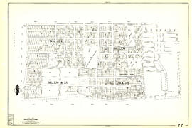
Sheet 77 : Kerr Street to Greenall Avenue and Southeast Marine Drive to Asquith Avenue
Part of City of Vancouver Archives technical and cartographic drawing collection
Item is a section showing the area from Kerr Street to Greenall Avenue and Southeast Marine Drive to Asquith Avenue. Includes streets, blocks, lots and legal descriptions, and the location of parks.
Vancouver (B.C.). Engineering Services

Sheet 76 : Kerr Street to Mondy Avenue and Asquith Avenue to Forty-ninth Avenue
Part of City of Vancouver Archives technical and cartographic drawing collection
Item is a section showing the area from Kerr Street to Mondy Avenue and Asquith Avenue to Forty-ninth Avenue. Includes streets, blocks, lots and legal descriptions, and the locations of schools, parks and cemeteries.
Vancouver (B.C.). Engineering Services

Sheet 75 : Nanaimo Street to Kerr Street and Bobolink Avenue to Forty-ninth Avenue
Part of City of Vancouver Archives technical and cartographic drawing collection
Item is a section showing the area from Nanaimo Street to Kerr Street and Bobolink Avenue to Forty-ninth Avenue. Includes streets, blocks, lots and legal descriptions, and the locations of schools, parks and golf courses.
Vancouver (B.C.). Engineering Services

Sheet 74 : Inverness Street to Nanaimo Street and Sixty-first Avenue to Forty-ninth Avenue
Part of City of Vancouver Archives technical and cartographic drawing collection
Item is a section showing the area from Inverness Street to Nanaimo Street and Sixty-first Avenue to Forty-ninth Avenue. Includes streets, blocks, lots and legal descriptions, and the locations of schools and parks.
Vancouver (B.C.). Engineering Services

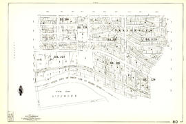
Sheet 73 : Quebec Street to Inverness Street and Fifty-seventh Avenue to Forty-seventh Avenue
Part of City of Vancouver Archives technical and cartographic drawing collection
Item is a section showing the area from Quebec Street to Inverness Street and Fifty-seventh Avenue to Forty-seventh Avenue. Includes streets, blocks, lots and legal descriptions, and the locations of schools and parks.
Vancouver (B.C.). Engineering Services

Sheet 72 : Oak Street to Quebec Street and Fifty-eighth Avenue to Forty-sixth Avenue
Part of City of Vancouver Archives technical and cartographic drawing collection
Item is a section showing the area from Oak Street to Quebec Street and Fifty-eighth Avenue to Forty-sixth Avenue. Includes streets, blocks, lots and legal descriptions, and the locations of schools and parks.
Vancouver (B.C.). Engineering Services

Sheet 71 : Cypress Street to Oak Street and Fifty-seventh Avenue to Forty-ninth Avenue
Part of City of Vancouver Archives technical and cartographic drawing collection
Item is a section showing the area from Cypress Street to Oak Street and Fifty-seventh Avenue to Forty-ninth Avenue. Includes streets, blocks, lots and legal descriptions.
Vancouver (B.C.). Engineering Services

Sheet 70 : Macdonald Street to Cypress Street and Fifty-seventh Avenue to Forty-ninth Avenue
Part of City of Vancouver Archives technical and cartographic drawing collection
Item is a section showing the area from Macdonald Street to Cypress Street and Fifty-seventh Avenue to Forty-ninth Avenue. Includes streets, blocks, lots and legal descriptions, and the locations of golf courses, parks and railways.
Vancouver (B.C.). Engineering Services

Part of City of Vancouver Archives technical and cartographic drawing collection
Item is a section showing the area from Musqueam Indian Reserve to Macdonald Street and North Arm of the Fraser River to Forty-ninth Avenue. Includes streets, blocks, lots and legal descriptions, and golf courses.
Vancouver (B.C.). Engineering Services

Part of City of Vancouver Archives technical and cartographic drawing collection
Item is a section showing the area from Musqueam Indian Reserve to Musqueam Park and North Arm, Fraser River to Southwest Marine Drive. Includes streets, blocks, lots and legal descriptions, and parks.
Vancouver (B.C.). Engineering Services

Sheet 66 : Musqueam Indian Reserve to Balaclava Street and Forty-ninth Avenue to Forty-first Avenue
Part of City of Vancouver Archives technical and cartographic drawing collection
Item is a section showing the area from Musqueam Indian Reserve to Balaclava Street and Forty-ninth Avenue to Forty-first Avenue. Includes streets, blocks, lots and legal descriptions, and the locations of schools, parks and golf courses.
Vancouver (B.C.). Engineering Services

Sheet 65 : Camosun Street to Carnarvon Street and Forty-first Avenue to Thirty-third Avenue
Part of City of Vancouver Archives technical and cartographic drawing collection
Item is a section showing the area from Camosun Street to Carnarvon Street and Forty-first Avenue to Thirty-third Avenue. Includes streets, blocks, lots and legal descriptions, and schools.
Vancouver (B.C.). Engineering Services
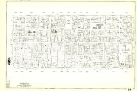
Sheet 64 : Balaclava Street to Cypress Street and Forty-ninth Avenue to Forty-first Avenue
Part of City of Vancouver Archives technical and cartographic drawing collection
Item is a section showing the area from Balaclava Street to Cypress Street and Forty-ninth Avenue to Forty-first Avenue. Includes streets, blocks, lots and legal descriptions, and the locations of parks and schools.
Vancouver (B.C.). Engineering Services

Sheet 63 : Carnarvon Street to Cypress Street and Forty-first Avenue to Thirty-third Avenue
Part of City of Vancouver Archives technical and cartographic drawing collection
Item is a section showing the area from Carnarvon Street to Cypress Street and Forty-first Avenue to Thirty-third Avenue. Includes streets, blocks, lots and legal descriptions, and the locations of parks and schools.
Vancouver (B.C.). Engineering Services

Sheet 62 : Cypress Street to Oak Street and Forty-ninth Avenue to Forty-first Avenue
Part of City of Vancouver Archives technical and cartographic drawing collection
Item is a section showing the area from Cypress Street to Oak Street and Forty-ninth Avenue to Forty-first Avenue. Includes streets, blocks, lots and legal descriptions, and the locations of parks and schools.
Vancouver (B.C.). Engineering Services

Sheet 61 : Cypress Street to Oak Street and Forty-first Avenue to Thirty-third Avenue
Part of City of Vancouver Archives technical and cartographic drawing collection
Item is a section showing the area from Cypress Street to Oak Street and Forty-first Avenue to Thirty-third Avenue. Includes streets, blocks, lots and legal descriptions.
Vancouver (B.C.). Engineering Services
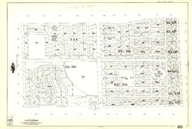
Sheet 60 : Oak Street to Quebec Street and Forty-sixth Avenue to Thirty-seventh Avenue
Part of City of Vancouver Archives technical and cartographic drawing collection
Item is a section showing the area from Oak Street to Quebec Street and Forty-sixth Avenue to Thirty-seventh Avenue. Includes streets, blocks, lots and legal descriptions, and the locations of parks and schools.
Vancouver (B.C.). Engineering Services

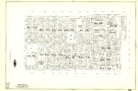
Sheet 59 : Quebec Street to Inverness Street and Forty-seventh Avenue to Thirty-seventh Avenue
Part of City of Vancouver Archives technical and cartographic drawing collection
Item is a section showing the area from Quebec Street to Inverness Street and Forty-seventh Avenue to Thirty-seventh Avenue. Includes streets, blocks, lots and legal descriptions, and the locations of parks, schools and Mountainview Cemetery.
Vancouver (B.C.). Engineering Services
Sheet 58 : Inverness Street to Nanaimo Street and Forty-ninth Avenue to Forty-first Avenue
Part of City of Vancouver Archives technical and cartographic drawing collection
Item is a section showing the area from Inverness Street to Nanaimo Street and Forty-ninth Avenue to Forty-first Avenue. Includes streets, blocks, lots and legal descriptions, and the locations of parks and schools.
Vancouver (B.C.). Engineering Services

Part of City of Vancouver Archives technical and cartographic drawing collection
Item is a section showing the area from Nanaimo Street to Doman Street and Joyce Street and Forty-ninth Avenue to Forty-first Avenue. Includes streets, blocks, lots and legal descriptions, and the locations of parks and schools.
Vancouver (B.C.). Engineering Services

Sheet 56 : Doman Street and Joyce Street to Boundary Road and Forty-ninth Avenue to Kingsway
Part of City of Vancouver Archives technical and cartographic drawing collection
Item is a section showing the area from Doman Street and Joyce Street to Boundary Road and Forty-ninth Avenue to Kingsway. Includes streets, blocks, lots and legal descriptions. Also included is Central Park and B.C. Electric Railway tracks in Burnaby.
Vancouver (B.C.). Engineering Services

Part of City of Vancouver Archives technical and cartographic drawing collection
Item is a section showing the area from Cecil Street and McHardy Street to Boundary Road and Kingsway to Monmouth Avenue and Price Street. Includes streets, blocks, lots and legal descriptions, and B.C. Electric Railway line. Also included are streets, blocks and B.C. Electric Railway line in the area from Boundary Road to Patterson Avenue in Burnaby.
Vancouver (B.C.). Engineering Services

Part of City of Vancouver Archives technical and cartographic drawing collection
Item is a section showing the area from Nanaimo Street to Joyce Street, Cecil Street and McHardy Street and Forty-first Avenue to Ward Street and Vanness Avenue. Includes streets, blocks, lots and legal descriptions, and the locations of parks and schools.
Vancouver (B.C.). Engineering Services

Sheet 53 : Inverness Street to Nanaimo Street and Forty-first Avenue to Thirty-second Avenue
Part of City of Vancouver Archives technical and cartographic drawing collection
Item is a section showing the area from Inverness Street to Nanaimo Street and Forty-first Avenue to Thirty-second Avenue. Includes streets, blocks, lots and legal descriptions, and the location of parks.
Vancouver (B.C.). Engineering Services

Sheet 52 : Inverness Street to Nanaimo Street and Thirty-second Avenue to Twenty-second Avenue
Part of City of Vancouver Archives technical and cartographic drawing collection
Item is a section showing the area from Inverness Street to Nanaimo Street and Thirty-second Avenue to Twenty-second Avenue. Includes streets, blocks, lots and legal descriptions, and the locations of parks and schools.
Vancouver (B.C.). Engineering Services

Sheet 51 : Ontario Street to Inverness Street and Thirty-seventh Avenue to Twenty-eighth Avenue
Part of City of Vancouver Archives technical and cartographic drawing collection
Item is a section showing the area from Ontario Street to Inverness Street and Thirty-seventh Avenue to Twenty-eighth Avenue. Includes streets, blocks, lots and legal descriptions, and the locations of parks, schools and Mountainview Cemetery.
Vancouver (B.C.). Engineering Services

Sheet 50 : Oak Street to Ontario Street and Thirty-seventh Avenue to Twenty-eighth Avenue
Part of City of Vancouver Archives technical and cartographic drawing collection
Item is a section showing the area from Oak Street to Ontario Street and Thirty-seventh Avenue to Twenty-eighth Avenue. Includes streets, blocks, lots and legal descriptions, and the locations of parks, schools, hospitals, reservoirs, stadiums and RCMP barracks.
Vancouver (B.C.). Engineering Services

Sheet 49 : Arbutus Street to Oak Street and Thirty-third Avenue to Laurier Avenue
Part of City of Vancouver Archives technical and cartographic drawing collection
Item is a section showing the area from Arbutus Street to Oak Street and Thirty-third Avenue to Laurier Avenue. Includes streets, blocks, lots and legal descriptions, and the locations of parks and schools.
Vancouver (B.C.). Engineering Services

Sheet 48 : Blenheim Street to Arbutus Street and Thirty-third Avenue to Twenty-third Avenue
Part of City of Vancouver Archives technical and cartographic drawing collection
Item is a section showing the area from Blenheim Street to Arbutus Street and Thirty-third Avenue to Twenty-third Avenue. Includes streets, blocks, lots and legal descriptions, and the locations of parks and schools.
Vancouver (B.C.). Engineering Services
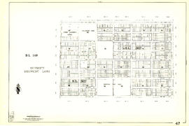
Sheet 47 : Camosun Street to Blenheim Street and Thirty-third Avenue to King Edward Avenue
Part of City of Vancouver Archives technical and cartographic drawing collection
Item is a section showing the area from Camosun Street to Blenheim Street and Thirty-third Avenue to King Edward Avenue. Includes streets, blocks, lots and legal descriptions, and the locations of parks and schools.
Vancouver (B.C.). Engineering Services
Sheet 46 : Blanca Street to Discovery Street and Sixteenth Avenue to Fourteenth Avenue
Part of City of Vancouver Archives technical and cartographic drawing collection
Item is a section showing the area from Blanca Street to Discovery Street and Sixteenth Avenue to Fourteenth Avenue. Includes streets, blocks, lots and legal descriptions.
Vancouver (B.C.). Engineering Services
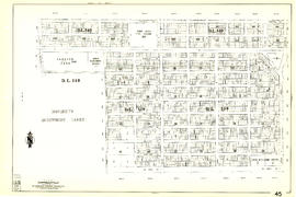
Sheet 45 : Discovery Street to Blenheim Street and King Edward Avenue to Fourteenth Avenue
Part of City of Vancouver Archives technical and cartographic drawing collection
Item is a section showing the area from Discovery Street to Blenheim Street and King Edward Avenue to Fourteenth Avenue. Includes streets, blocks, lots and legal descriptions, and the locations of parks and schools.
Vancouver (B.C.). Engineering Services

Sheet 44 : Blenheim Street to Arbutus Street and King Edward Avenue to Fourteenth Avenue
Part of City of Vancouver Archives technical and cartographic drawing collection
Item is a section showing the area from Blenheim Street to Arbutus Street and King Edward Avenue to Fourteenth Avenue. Includes streets, blocks, lots and legal descriptions, and the locations of parks, schools and railways.
Vancouver (B.C.). Engineering Services

Sheet 43 : East Boulevard to Oak Street and Laurier Avenue to Fourteenth Avenue
Part of City of Vancouver Archives technical and cartographic drawing collection
Item is a section showing the area from East Boulevard to Oak Street and Laurier Avenue to Fourteenth Avenue. Includes streets, blocks, lots and legal descriptions, and the locations of parks and schools.
Vancouver (B.C.). Engineering Services

Sheet 42 : Oak Street to Ontario Street and Twenty-eighth Avenue to Sixteenth Avenue
Part of City of Vancouver Archives technical and cartographic drawing collection
Item is a section showing the area from Oak Street to Ontario Street and wenty-eighth Avenue to Sixteenth Avenue. Includes streets, blocks, lots and legal descriptions, and the locations of parks and schools.
Vancouver (B.C.). Engineering Services