Showing 94 results
Archival description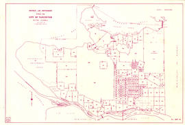
District lot boundaries with the City of Vancouver, British Columbia

Index to 400 ft. scale section maps, City of Vancouver, British Columbia

Map showing location of single men receiving assistance by mail

Map showing location of single women receiving assistance by mail

Sheet 31 : Oak Street to Main Street and Sixteenth Avenue to Fourth Avenue and False Creek

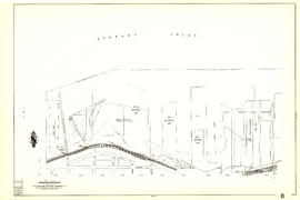
Plan showing vicinity of Fisher Case, Nov 9th, 1949

City of Vancouver, British Columbia

City of Vancouver, British Columbia

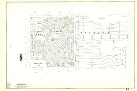
Redevelopment plan for Jericho Department of National Defence lands
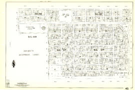
Sheet 45 : Discovery Street to Blenheim Street and King Edward Avenue to Fourteenth Avenue

Sheet 44 : Blenheim Street to Arbutus Street and King Edward Avenue to Fourteenth Avenue

Sheet 43 : East Boulevard to Oak Street and Laurier Avenue to Fourteenth Avenue

Sheet 42 : Oak Street to Ontario Street and Twenty-eighth Avenue to Sixteenth Avenue

Sheet 41 : Ontario Street to Inverness Street and Twenty-eighth Avenue to Sixteenth Avenue

Sheet 40 : Inverness Street to Nanaimo Street and Twenty-second Avenue to Thirteenth Avenue

Sheet 39 : Kingsway and Nanaimo Street to Rupert Street and Ward Street to Twenty-second Avenue

Sheet 38 : Nanaimo Street to Rupert Street and Twenty-second Avenue to Grandview Highway

Sheet 37 : Rupert Street to Carleton Avenue and Wellington Avenue to Twenty-second Avenue and Elmwood Street
Sheet 36 : Rupert Street to Carlton Avenue and Twenty-second Avenue to Grandview Highway

Sheet 35 : Rupert Street to Ardley Avenue and Grandview Highway to Fifth Avenue

Sheet 34 : Nanaimo Street to Rupert Street and Grandview Highway to Fifth Avenue

Sheet 30 : Maple Street to Oak Street and Fourteenth Avenue to Third Avenue and False Creek

Sheet 29 : Balaclava Street to Maple Street and Fourteenth Avenue to Third Avenue

Sheet 28 : Camosun Street to Balaclava Street and Fourteenth Avenue to Fourth Avenue
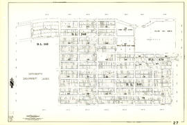
Sheet 27 : University Endowment Lands and Drummond Drive to Camosun Street and Fourteenth Avenue to Fourth Avenue

Sheet 26 : University Endowment Lands to Blanca Street and Fourth Avenue to Spanish Banks Beach

Sheet 25 : Blanca Street to Jericho Beach and Fourth Avenue to Locarno Beach
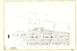
Sheet 24 : Jericho Beach to Balaclava Street and Fourth Avenue to Cameron Avenue

Sheet 23 : Balaclava Street to Maple Street and Third Avenue to English Bay

Sheet 22 : Maple Street to Drake Street and Fourth Avenue to Thurlow Street

Sheet 21 : Homer Street to Main Street and Fourth Avenue to Georgia Viaduct

Sheet 20 : Main Street to Clark Drive and Great Northern Way to Prior Street

Sheet 19 : Clark Drive to Nanaimo Street and Second Avenue to Frances Street

Sheet 18 : Nanaimo Street to Rupert Street and Fifth Avenue to Charles Street

Sheet 17 : Nanaimo Street to Rupert Street and Charles Street to Pender Street
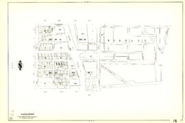
Sheet 16 : Rupert Street to Boundary Road and Fifth Avenue to Kitchener Street
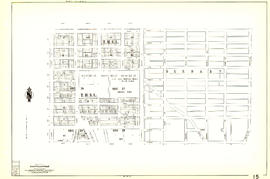
Sheet 15 : Rupert Street to Boundary Road and Kitchener Street to Pender Street

Sheet 14 : Cassiar Street to Boundary Road and Pender Street to Eton Street

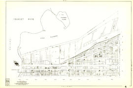
Sheet 13 : Rupert Street to Boundary Road and Eton Street to Burrard Inlet

Sheet 12 : Nanaimo Street to Cassiar Street and Pender Street to McGill Street

Sheet 11 : Wall Street to Rupert Street and McGill Street to Burrard Inlet

Sheet 10 : Clark Drive to Nanaimo Street and Frances Street to Burrard Inlet

Sheet 5 : Stanley Park to Nicola Street and English Bay Beach to Robson Street
Sheet 4 : Chilco Street to Burrard Street and Robson Street to Coal Harbour

Sheet 9 : Main Street to Clark Drive and Prior Street to Burrard Inlet
Sheet 8 : Main Street to Clark Drive and Alexander Street to Burrard Inlet

Sheet 7 : Burrard Street to Main Street and Georgia Viaduct to Burrard Inlet

Sheet 6 : Nicola Street to Beatty Street and English Bay Beach to Georgia Street

Sheet 33 : Clark Drive to Nanaimo Street and Thirteenth Avenue to Second Avenue

Sheet 32 : Main Street to Clark Drive and Sixteenth Avenue to Great Northern Way
Results 1 to 50 of 94