Engineering Department technical drawings, maps and plans
Engineering Department technical drawings, maps and plans
Water supply development records
Water supply development records
Local improvements miscellany
Local improvements miscellany
Engineering Department annual correspondence
Engineering Department annual correspondence
Engineering Department miscellaneous records
Engineering Department miscellaneous records
Water works register of appropriations for roadwork
Water works register of appropriations for roadwork
Vancouver bridge records
Vancouver bridge records
Engineering Department miscellaneous photographs
Engineering Department miscellaneous photographs
Engineering Department old policy files
Engineering Department old policy files
Water works distributing journals
Water works distributing journals
Engineering Department contract register
Engineering Department contract register
Bridge engineer J. R. Grant's subject files
Bridge engineer J. R. Grant's subject files
Rain gauge registers
Rain gauge registers
Main Street sea wall construction photographs
Main Street sea wall construction photographs
Georgia Viaduct and Granville Street Bridge photographs
Georgia Viaduct and Granville Street Bridge photographs

Plan of block occupied by University of British Columbia, Vancouver B.C.
Engineering Department photograph collection
Engineering Department photograph collection
1886-1936 "Golden Jubilee: Greater Vancouver
1886-1936 "Golden Jubilee: Greater Vancouver
Engineering Department traffic accident index cards
Engineering Department traffic accident index cards

Plan showing vicinity of Fisher Case, Nov 9th, 1949
Granville Street Bridge construction photographs by Lew Parry Film Productions
Granville Street Bridge construction photographs by Lew Parry Film Productions
Transportation Planning Engineer Expo 86 files
Transportation Planning Engineer Expo 86 files

Plan & profile of south side of First Ave., between Renfrew St. & Nootka St.

Sheet 61 : Cypress Street to Oak Street and Forty-first Avenue to Thirty-third Avenue

Sheet 62 : Cypress Street to Oak Street and Forty-ninth Avenue to Forty-first Avenue

Sheet 10 : Clark Drive to Nanaimo Street and Frances Street to Burrard Inlet

Sheet 12 : Nanaimo Street to Cassiar Street and Pender Street to McGill Street

Sheet 14 : Cassiar Street to Boundary Road and Pender Street to Eton Street

Sheet 20 : Main Street to Clark Drive and Great Northern Way to Prior Street

Sheet 25 : Blanca Street to Jericho Beach and Fourth Avenue to Locarno Beach

Sheet 26 : University Endowment Lands to Blanca Street and Fourth Avenue to Spanish Banks Beach

Sheet 29 : Balaclava Street to Maple Street and Fourteenth Avenue to Third Avenue

Sheet 31 : Oak Street to Main Street and Sixteenth Avenue to Fourth Avenue and False Creek

Sheet 35 : Rupert Street to Ardley Avenue and Grandview Highway to Fifth Avenue

Sheet 38 : Nanaimo Street to Rupert Street and Twenty-second Avenue to Grandview Highway

Sheet 41 : Ontario Street to Inverness Street and Twenty-eighth Avenue to Sixteenth Avenue

Sheet 42 : Oak Street to Ontario Street and Twenty-eighth Avenue to Sixteenth Avenue

Sheet 49 : Arbutus Street to Oak Street and Thirty-third Avenue to Laurier Avenue

Sheet 57 : Nanaimo Street to Doman Street and Joyce Street and Forty-ninth Avenue to Forty-first Avenue

Sheet 59 : Quebec Street to Inverness Street and Forty-seventh Avenue to Thirty-seventh Avenue
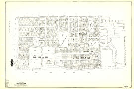
Sheet 77 : Kerr Street to Greenall Avenue and Southeast Marine Drive to Asquith Avenue

Sheet 79 : Gladstone Street to Kerr Street and North Arm of Fraser River to Bobolink Avenue

Sheet 89 : North Arm of Fraser River to Southwest Marine Drive and Barnard Street
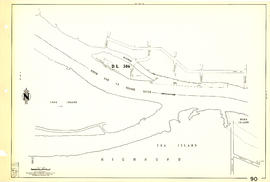
Sheet 90 : Carrington Street to Macdonald Street and Richmond to Celtic Avenue

Sheet 33 : Clark Drive to Nanaimo Street and Thirteenth Avenue to Second Avenue

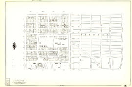
Sheet 5 : Stanley Park to Nicola Street and English Bay Beach to Robson Street

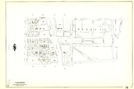
Sheet 11 : Wall Street to Rupert Street and McGill Street to Burrard Inlet

Sheet 13 : Rupert Street to Boundary Road and Eton Street to Burrard Inlet
Sheet 15 : Rupert Street to Boundary Road and Kitchener Street to Pender Street
Sheet 16 : Rupert Street to Boundary Road and Fifth Avenue to Kitchener Street