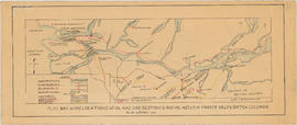
Plan showing locations of oil and gas seepages and oil wells in Fraser Valley, British Columbia
- AM1594-: MAP 760a
- Item
- [between 1912 and 1929]
Part of City of Vancouver Archives technical and cartographic drawing collection
Item is a map which shows rivers and streams, oil and gas seepages, oil wells drilled, towns and villages and railway lines from Pitt Lake in the north to the United States border in the south and from Chilliwack in the east to the Strait of Georgia in the west.
Haggen, E.A.