Showing 11 results
Archival description10 results with digital objects Show results with digital objects

Vancouver, British Columbia

Plan showing lands occupied in Stanley Park near Brockton Point. City of Vancouver B.C.

Plan showing polling divisions, City of Vancouver, B.C.

Sketch showing traffic plan for night functions in Stanley Park during Golden Jubilee period
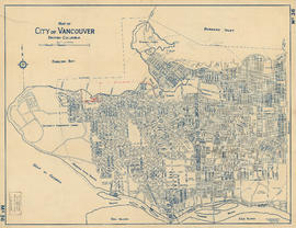
Map of City of Vancouver, British Columbia

Location of ferry pedestrian subway, Vancouver, B.C.

Plan of part of D.L. 540

Plan of portions of False Creek (Kitsilano) Indian Reserve, Vancouver, B.C., required for Burrard Street Bridge right-of-way

Schedule "A" : polling districts, City of Vancouver
![Sectional map [Kaslo Street to Yale Street to Cotton Drive to East 1st Avenue]](/uploads/r/null/5/b/5b3ce173622ff68f920706abdf2b71af76caf9469cb2cbd3346b37f55694015e/4e7b285b-63cb-45b1-8e0c-6002788dbae6-MAP427_142.jpg)
Sectional map [Kaslo Street to Yale Street to Cotton Drive to East 1st Avenue]
Plan of Kitsilano Indian Reserve, No. 6 (contours)
Plan of Kitsilano Indian Reserve, No. 6 (contours)