Showing 44 results
Archival description
The official street name map of the City of Vancouver

Schedule "A" : polling districts, City of Vancouver

Plan of occupations at Forty-second Avenue and Yew Street
![False Creek development : san [sanitary] sewers tentative layout](/uploads/r/null/c/a/ca111eaa497f59a66ecdad4c91bfb2238f21efb21b91a1172f460ef16667055f/4da08847-7457-4d4c-8938-e4c6c1dc50c3-MAP692_142.jpg)
False Creek development : san [sanitary] sewers tentative layout

Viaduct from Burrard Bridgehead to Arbutus St. at 6th Ave
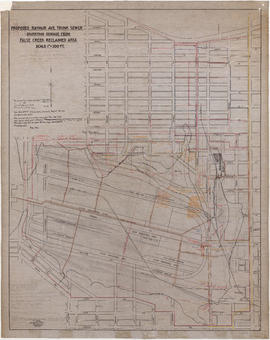
Proposed Raymur Ave. trunk sewer diverting sewage from False Creek reclaimed area

Proposed Raymur Ave. trunk sewer diverting sewage from False Creek reclaimed area

Proposed Raymur Ave. trunk sewer diverting sewage from False Creek reclaimed area
![Plan of converted 4-piece square base standard [street light]](/uploads/r/null/a/6/2/a620fe2056a7ce78337e51da4b09cb570db33a6089213c0e6f07948cc8135f4c/279b1696-21a7-4cf7-9129-75bc5b98fced-LEG1967_142.jpg)
Plan of converted 4-piece square base standard [street light]

Mercury incandescant standards for the park roadway

Plan and profile of 4th Avenue from Lakewood Dr. to Templeton Dr.
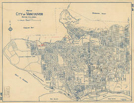
Map of City of Vancouver, British Columbia

Plan showing polling divisions, City of Vancouver, B.C.

Sketch showing traffic plan for night functions in Stanley Park during Golden Jubilee period
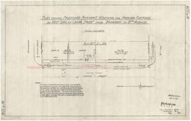
Plan showing proposed pavement widening for parking purposes
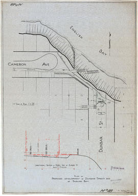
Plan of proposed development of Dunbar Street end at English Bay

Vancouver, British Columbia

Plan of portions of False Creek (Kitsilano) Indian Reserve, Vancouver, B.C., required for Burrard Street Bridge right-of-way

Plan of City float 1st July parade 1926
![Sectional map [Kaslo Street to Yale Street to Cotton Drive to East 1st Avenue]](/uploads/r/null/5/b/5b3ce173622ff68f920706abdf2b71af76caf9469cb2cbd3346b37f55694015e/4e7b285b-63cb-45b1-8e0c-6002788dbae6-MAP427_142.jpg)
Sectional map [Kaslo Street to Yale Street to Cotton Drive to East 1st Avenue]

Plan showing lands occupied in Stanley Park near Brockton Point. City of Vancouver B.C.

Reinforced concrete details, Hamilton Street convenience

Plan of public convenience, Hamilton Street, Vancouver B.C.

Drainage and electrical wiring plan, for public convenience, Hamilton Street, Vancouver B.C.

Plan of proposed public convenience, Georgia & Granville Sts., Vancouver, B.C.

Floor plan and elevation of toilets

Development of railway properties at 1st Avenue and Main Street

Proposed amended layout for connections from C.P.R. to properties between Woodland Drive and Salisbury Drive

Proposed sanitary convenience at S. end of Granville Bridge
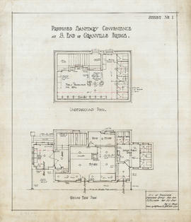
Proposed sanitary convenience at S. end of Granville Bridge.

Proposed sanitary convenience at S. end of Granville Bridge

Proposed sanitary convenience at S. end of Granville Bridge

4th Ave & Granville St. convenience

Proposed convenience at Kingsway & Main St.

Details of toilets

Proposed store and sanitary convenience at S. end of Granville Bridge

Proposed convenience at south end of Granville Bridge
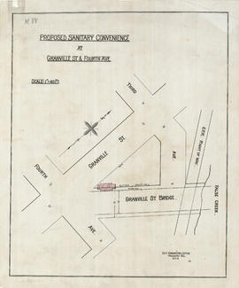
Proposed sanitary convenience at Granville Street & Fourth Avenue

Proposed sanitary convenience Fourth Ave & Granville St

Location of ferry pedestrian subway, Vancouver, B.C.

Plan of Paterson's property, block 364 D.L. 562, City of Vancouver, B.C.
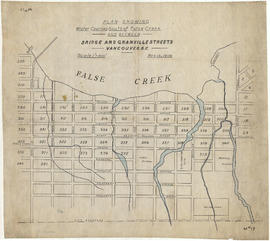
Plan showing water courses south of False Creek and between Bridge and Granville Street

Plan of part of D.L. 540
Contour plan of Stanley Park