
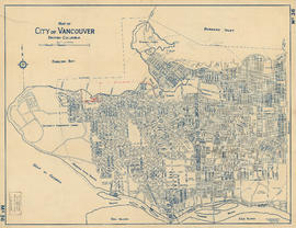
The official street name map of the City of Vancouver
- COV-S36---: MAP 336
- Item
- 1963
Part of City of Vancouver fonds
Item is a map created to accompany a street naming by-law.
Vancouver (B.C.). Engineer's Office
22 results with digital objects Show results with digital objects
The official street name map of the City of Vancouver
Part of City of Vancouver fonds
Item is a map created to accompany a street naming by-law.
Vancouver (B.C.). Engineer's Office

Part of City of Vancouver Archives technical and cartographic drawing collection
Map shows proposed route for entry to the Burrard Street Bridge from Cornwall and Cedar Streets. Survey overseen by George Frederick Fountain, Land Surveyor of the City of Vancouver, March 26, 1930. Correctness of survey sworn before H. J. Painter, a notary public for the Province of British Columbia, April 8, 1930.
Vancouver (B.C.). Engineer's Office
Map of City of Vancouver, British Columbia
Part of City of Vancouver Archives technical and cartographic drawing collection
Item is a map annotated to show the Naval Reserve at Jericho and its distance, in chains, to Granville Island. Base map shows streets, parks, golf courses, and distances from City Hall.
Vancouver (B.C.). Engineer's Office

Drainage and electrical wiring plan, for public convenience, Hamilton Street, Vancouver B.C.
Part of City of Vancouver fonds
Item is an architectural drawing showing plans for public washrooms on Hamilton Street, between Pender Street and Hastings Street in downtown Vancouver, B.C. The drawing includes a floor plan, a longitudinal section, a plan of the sidewalk top, and a location plan. Drain, vent pipes, and electric wiring are shown.
Vancouver (B.C.). Engineer's Office

Plan of public convenience, Hamilton Street, Vancouver B.C.
Part of City of Vancouver fonds
Item is an architectural drawing showing plans for public washrooms on Hamilton Street, between Pender Street and Hastings Street in downtown Vancouver, B.C. The drawing includes a floor plan, a longitudinal section, a plan of the sidewalk top, and a location plan, which include notes about construction and building materials.
Vancouver (B.C.). Engineer's Office

Reinforced concrete details, Hamilton Street convenience
Part of City of Vancouver fonds
Item is an architectural drawing showing details regarding the reinforced concrete for public washrooms on Hamilton Street, downtown Vancouver, B.C.
Vancouver (B.C.). Engineer's Office

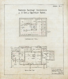
Proposed convenience at south end of Granville Bridge
Part of City of Vancouver fonds
Item is an architectural drawing showing three views of the proposed convenience: elevation to Granville St. Bridge, underground plan, and plan on bridge elevation.
Vancouver (B.C.). Engineer's Office

4th Ave & Granville St. convenience
Part of City of Vancouver fonds
Item is an architectural drawing showing two views of the proposed convenience: a cross section and elevation to Granville St.
Vancouver (B.C.). Engineer's Office

Proposed sanitary convenience Fourth Ave & Granville St
Part of City of Vancouver fonds
Item is an architectural drawing showing views of the proposed convenience: plan of ground floor, elevation to Granville Bridge, plan of basement, and cross section.
Vancouver (B.C.). Engineer's Office

Proposed sanitary convenience at S. end of Granville Bridge
Part of City of Vancouver fonds
Item consists of an architectural drawings depicting the design of a public toilet to be located at the south end of the Granville Street Bridge. Drawing depicts cross section and longitudinal section of the building.
Vancouver (B.C.). Engineer's Office

Proposed sanitary convenience at S. end of Granville Bridge
Part of City of Vancouver fonds
Item consists of an architectural drawing depicting the design of a public toilet located at the south end of the Granville Street Bridge. The drawing depicts a side (end) elevation and location plan.
Vancouver (B.C.). Engineer's Office

Proposed sanitary convenience at S. end of Granville Bridge
Part of City of Vancouver fonds
Item consists of an architectural drawing depicting design of a public toilet to be erected at the south end of Granville Bridge. The sheet depicts the front and rear elevations.
Vancouver (B.C.). Engineer's Office
Proposed sanitary convenience at S. end of Granville Bridge.
Part of City of Vancouver fonds
Item consists of an architectural drawing depicting floor plans of the proposed building.
Vancouver (B.C.). Engineer's Office
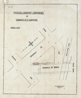
Proposed sanitary convenience at Granville Street & Fourth Avenue
Part of City of Vancouver fonds
Item is an architectural drawing depicting a proposed public toilet near Granville St. and Fourth Ave. The drawing depicts a site plan.
Vancouver (B.C.). Engineer's Office

Proposed store and sanitary convenience at S. end of Granville Bridge
Part of City of Vancouver fonds
Item is an architectural drawing depicting the design of a proposed public toilet facility and store. The drawing depicts the Granville Street elevation.
Vancouver (B.C.). Engineer's Office

Plan of proposed public convenience, Georgia & Granville Sts., Vancouver, B.C.
Part of City of Vancouver fonds
Item is an architectural drawing of a public toilet and includes a floor plan, longitudinal section, and location plan.
Vancouver (B.C.). Engineer's Office

Proposed convenience at Kingsway & Main St.
Part of City of Vancouver fonds
Item is an architectural drawing of an underground public toilet facility. Drawing includes pans and cross-sections.
Vancouver (B.C.). Engineer's Office

Plan showing polling divisions, City of Vancouver, B.C.
Part of City of Vancouver Archives technical and cartographic drawing collection
Item is a map shows polling divisions and poll station locations within each division, created as a Schedule to by-law no. 2434, which defined polling division boundaries.
Vancouver (B.C.). Engineer's Office

Schedule "A" : polling districts, City of Vancouver
Part of City of Vancouver Archives technical and cartographic drawing collection
Item is a sheet with four maps created to accompany by-law 3631, defining revisions to polling district boundaries. The by-law revises by-law 3256.
Vancouver (B.C.). Engineer's Office

Part of City of Vancouver Archives technical and cartographic drawing collection
Item is a map depicting the "original plan" for District Lot 540, including the area bounded by Trafalgar Street to English bay to Campbell Street to 16th Avenue. Block numbers and the location of public parks are noted.
Vancouver (B.C.). Engineer's Office

Part of City of Vancouver Archives technical and cartographic drawing collection
Item is a copy of a map of Vancouver which has been hand annotated. The annotations appear to relate to proposed revisions to the street network, including major streets to be widened and new major street connections.
Vancouver (B.C.). Engineer's Office

Location of ferry pedestrian subway, Vancouver, B.C.
Part of City of Vancouver Archives technical and cartographic drawing collection
Item is an architectural drawing depicting a subway (underground) pedestrian walkway to run underneath the Canadian Pacific Railway tracks, linking Alexander Street to the North Vancouver Ferry Co. dock. Ramp grades are indicated. The drawing shows the location of the North Vancouver Ferry Company; Evans, Coleman and Evans Limited; and the Grand Trunk Pacific Railway Company.
Vancouver (B.C.). Engineer's Office