- AM358-: MAP 681
- File
- [before July 6, 1909]
Part of H.A. Price collection
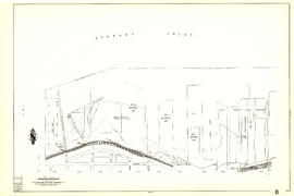
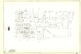
Item is a sectional map showing the Eburne [Marpole] tyo New Westminster branch line of the Vancouver and Lulu Island Railway. The map also shows District Lot lot numbers and names associated with properties adjacent to the line.
Canadian Pacific Railway Company. Engineering Office


![Prince Rupert : Atlin Fisheries etc. [Barrett train station]](/uploads/r/null/5/f/a/5fa8396d10c9032f74b64fba99a825acc7a0a69a3add1c0c02b710e19e1b770c/328adf1f-66db-4311-9a8a-f14fb1396ae9-CVA586-14906_142.jpg)


![[Aerial view of Burrard Inlet, Hastings-Sunrise, Burnaby and the District of North Vancouver]](/uploads/r/null/d/f/df7e11c97173ce0473c454f0a01569b641972f6efdc12bf192edbc42119542d6/6d72f89b-9b55-48c4-bef6-04eb2137f1d3-A66600_142.jpg)
![[Aerial view of Burrard Inlet, Vancouver waterfront and North Vancouver waterfront]](/uploads/r/null/7/e/7ebb42bad115eb635562fde51fb418b1e63ecf9048f15193681f167f6966c96a/874ecdbf-b7e9-4561-b45f-1003efcc073f-A66601_142.jpg)