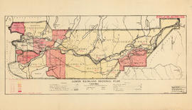
Lower Mainland Regional Plan : population distribution
- AM683-S5---: LEG1349.02
- Item
- Sept. 1, 1945
Part of Community Planning Association of Canada, British Columbia Division fonds
6 results with digital objects Show results with digital objects
Lower Mainland Regional Plan : population distribution
Part of Community Planning Association of Canada, British Columbia Division fonds
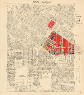
Actual occupancy : area bounded by Joyce Street, Boundary Road, Wellington Avenue and Kingsway
Part of City of Vancouver fonds

City of Vancouver : households and population by enumeration areas : 1961 census
Part of City of Vancouver fonds
Item is a map annotated to show census tract numbers and boundaries, enumeration area boundaries, and households and pooulation within enumeration areas. Other numbers are hand-written on some of the areas, but the meaning of these numbers is unknown. Base map shows streets, parks, and golf courses.

Map showing location of single men receiving assistance by mail
Part of City of Vancouver Archives technical and cartographic drawing collection
Item is a map showing the City of Vancouver covered with annotations to represent the numbers of men in particular areas receiving assistance by mail. Map is a copy of the original and it is not possible to determine the original colour coding.
Vancouver (B.C.). Engineering Services

Map showing location of single women receiving assistance by mail
Part of City of Vancouver Archives technical and cartographic drawing collection
Item is a map showing the City of Vancouver covered with annotations to represent the numbers of women in particular areas receiving assistance by mail. Map is a copy of the original and it is not possible to determine the original colour coding.
Vancouver (B.C.). Engineering Services

City and District of North Vancouver
Part of City of Vancouver Archives technical and cartographic drawing collection
Item is a map showing the city and district of North Vancouver. It shows paved roads, gravel roads, unopened roads and a graphical depiction of the population as of 1947. A small inset map shows the position of the city of North Vancouver and the district of North Vancouver in relation to Vancouver, Burrard Inlet and West Vancouver. Annotations appear to be in J.S. Matthews' hand, noting a portion of North Vancouver as "King's Lynn".